A very interesting essay from a resident of NYC, who feels that they are paying the price for upstate sprawl:
-Bill Collins
A very interesting essay from a resident of NYC, who feels that they are paying the price for upstate sprawl:
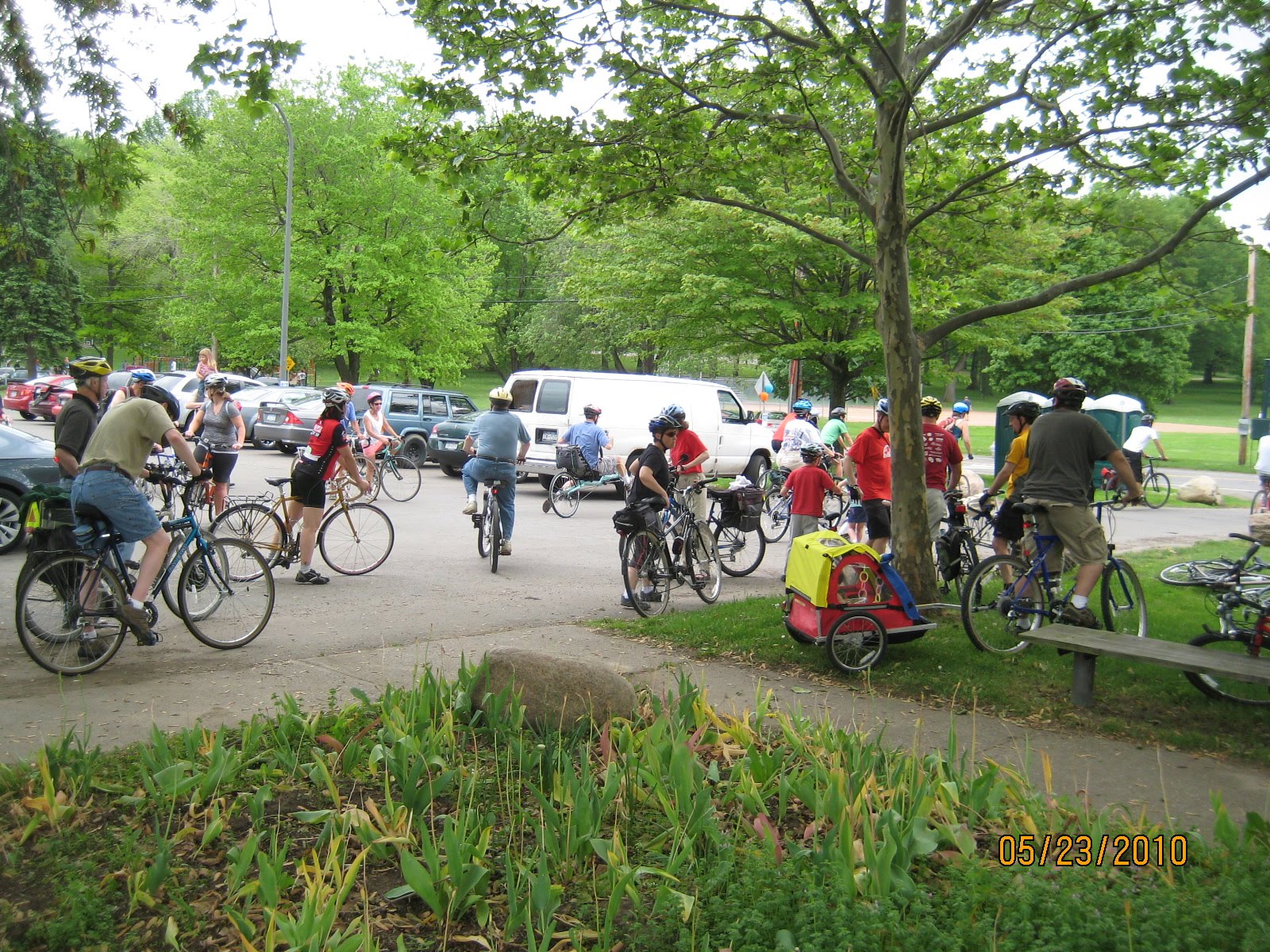
On Sunday, May 23 at 1 PM in Cobbs Hill Park, over forty bicyclists began a bicycle boulevard demonstration ride through the Upper Monroe neighborhood in Rochester, New York. They were not racers, or members of a single bicycling club, or recruits for a charity ride. They were just ordinary folks finding out what a bicycle boulevard would look and feel like in our area.
Maybe it is a harbinger of things to come. Portland, Oregon’s next generation bicycle boulevards is already achieving what we are attempting here: “A low traffic volume and low traffic speed street where bicycles, pedestrians and neighbors are given priority.” Already, this concept is being introduced as one of the choices for the Bicycle Master Plan being developed by the City of Rochester and the county of Monroe.
Preparation for this demonstration ride began almost a year ago by choosing a neighborhood properly situated near the heart of the city, en route to popular generators. A generator is a destination that attracts traffic, like a supermarket, a city center, a theatre district, or, in Rochester’s case, its wonderful network of trails (including the New York State Canal Trail) which come to a hub at Genesee Park.
For this specific demonstration ride, a route from the Upper Monroe neighborhood was mapped out and temporarily signed, pointing out each turn of the ride. When fully developed, this bicycle boulevard would not only have permanent signage, it might have many other features like auto speed reduction, auto traffic reduction, and various changes to make crossing busy streets easier and safer. (http://www.bta4bikes.org/) Ultimately, Upper Monroe bicycle boulevards would be linked to a series of other boulevard routes throughout all our neighborhoods providing safe and enjoyable routes that make our neighborhoods more neighborly. Not to mention fewer fossil-burning vehicles, fewer ozone alert days, and a lighter impact on climate change.
What might tip the community from one that views bicycles, walking, and public transportation as peripheral ways of getting around to a city that is designed specifically around these transportation options? Maybe we could take our lead from Portland, Oregon, pack up all our influential community leaders, and send them to Boulder, Colorado or The Netherlands and let them see how they do it. Don’t laugh, it’s been done—and it worked!
 Bike 4 Breakfast (a Bike Week event) took place on Sunday, May 23rd from 8:00am – 11:00am. The ride started at Eastern Mountain Sports in Pittsford Plaza and followed the Canal Path to the Genesee River Path in route to the South Wedge Diner (located in Rochester’s South Wedge neighborhood). The people, weather and ride were all great! The total number of riders that participated was 14. Great event – look forward to offering it again sometime this summer.
Thanks to Chintana for helping out.
Bike 4 Breakfast (a Bike Week event) took place on Sunday, May 23rd from 8:00am – 11:00am. The ride started at Eastern Mountain Sports in Pittsford Plaza and followed the Canal Path to the Genesee River Path in route to the South Wedge Diner (located in Rochester’s South Wedge neighborhood). The people, weather and ride were all great! The total number of riders that participated was 14. Great event – look forward to offering it again sometime this summer.
Thanks to Chintana for helping out.
For motorists, potholes are an annoyance, but they can be extremely dangerous for cyclists! If you encounter potholes in the City of Rochester, you can use this on-line form to report them to the City for repair:
For motorists, potholes are an annoyance, but they can be extremely dangerous for cyclists! If you encounter potholes in the City of Rochester, you can use this on-line form to report them to the City for repair:

Rochester Cycling Alliance / Bike Week Commuter Race just finished – cyclist won after a close race. Times will be updated later and possibly a video too! Thanks to everyone who helped out with the race. Great way to start out Bike Week. Don’t miss the Light-up the River Ride tonight at 9:00PM. Visit: www.rochestercyclingalliance.org for details.
Rochester Cycling Alliance / Bike Week Commuter Race just finished – cyclist won after a close race. Times will be updated later and possibly a video too! Thanks to everyone who helped out with the race. Great way to start out Bike Week. Don’t miss the Light-up the River Ride tonight at 9:00PM. Visit: www.rochestercyclingalliance.org for details.
Rochester’s Bike Week starts tomorrow! Tomorrow is also National Bike to Work Day – BIKE TO WORK! Come support the Bike Week Commuter Race at 7:00am (Bicyclists vs. car vs. bus). Race will begin at Starbucks (Corner of Winton and Monroe) at 7:00am and terminates in front of the museum on Monroe Ave (just before Manhattan Sq Pk).
Rochester’s Bike Week starts tomorrow! Tomorrow is also National Bike to Work Day – BIKE TO WORK! Come support the Bike Week Commuter Race at 7:00am (Bicyclists vs. car vs. bus). Race will begin at Starbucks (Corner of Winton and Monroe) at 7:00am and terminates in front of the museum on Monroe Ave (just before Manhattan Sq Pk).
*Cross Posted by the Moderate Urban Champion
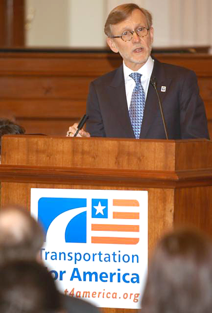 Members of Reconnect Rochester had a unique opportunity Monday afternoon. We were invited to sit in and participate in a roundtable discussion featuring representation of the Genesee Transportation Council, the Empire State Passengers Association, the Rochester Rail Transit Committee, and the keynote speaker of that evening’s lecture, John Robert Smith.
Not all of the biggest statements came from Smith himself, but his insight into federal agencies and funding acquisition from said agencies was very valuable to our coalition. Also heartening was the recognition by all parties of potential energy realities. This acceptance set the imperative tone regarding the necessity for improved transit in the region.
Smith’s greatest criticism, one that was repeated during the public lecture, was a lack of obvious attraction marketing, and the associated transportation options, to downtown hotel guests and travelers who arrive by train. The implication is that we aren’t successfully steering travelers with money to spend to restaurants and other cultural amenities. A set of newer signage as part of an enhanced wayfinder system was installed recently, but it is proving to be geared toward motorized tourist travel.

Anyone interested in a limited edition RCA T-shirt please email us
with your name, T-shirt size, phone number, and email. T-shirt cost
will be $20 per shirt. This cost is based on buying 12 T-shirts to start. The more people who buy them the cheaper they will be. We need orders by 10AM tomorrow (5/11) in order to get the shirts by this Friday. Please pass this message along and let all RCA’ers know about the shirts.
Shirts will be Red 50/50 cotton shirts with a white RCA Chain ring /Cityscape logo on the front and white “ROCHESTER CYCLING ALLIANCE” lettering on the back across the shoulders. To place an order for your shirt click here.


ATTENTION all RCA members with a Facebook page! If you have been looking for a way to help and support the RCA and Bike Week, but have been too busy to make it to meetings, etc. you can help-out by letting your friends know about the event through Facebook or email.
If you have a Facebook page please cut and paste the following message into your status:
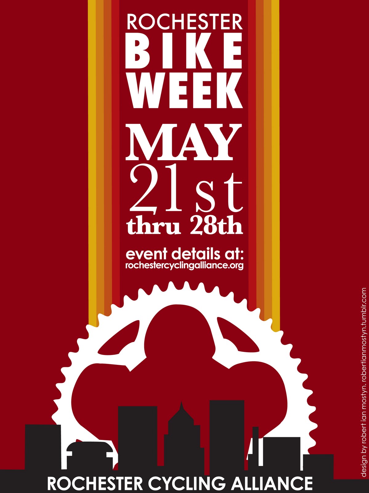
Rochester Bike Week is May 21st thru 28th. For a list of events visit: http://www.rochestercyclingalliance.org/
If you do not have facebook, but have an email account.. then simply send the above message to your friends via email.
Your help with messaging and getting the word out is crucial to the success of this event! What good is this event if no one knows about it! Also, frequent posts to your Facebook page over the next two weeks leading up to Bike Week will increase our messaging success!
SPREAD THE WORD! Thanks for your support…
Bike Week Committee

