In 2023, 40,990 people died from car crashes in the U.S and more than 2.7 million people went to emergency rooms for injuries. Monroe County alone sees an average of 47 deaths and 5,000 injuries each year. To honor these lives, Reconnect Rochester hosted a local event for the World Day of Remembrance on Sunday, November 16th, 2025 where we called on leaders across Monroe County to set safe speeds on local streets.
Josie McClary is a safe streets advocate, a Reconnect Rochester Board Member, and someone with a personal connection to road violence. She wrote this eulogy to commemorate the event.
Today we come together to honor the lives lost and the families forever changed by road crashes. For many of us, this day is deeply personal.
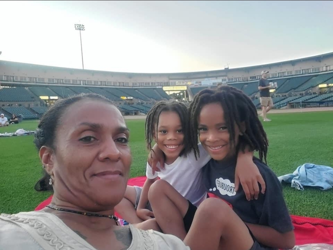
For me, it’s about my beloved, Ryan Grantham Jr. His life was full of joy and promise- and losing him changed my life and my grandson’s life forever.
That loss became my reason to advocate. It’s my WHY!- I believe our streets should connect us, not endanger us.
Every name we say today represents a story, a future, and a community left to carry their memory. We owe it to them – and to one another- to turn our grief into purpose.
We can do this by designing safer streets, slowing down, and listening to those who have lived with this pain.
Safety should never be a privilege – it should be a promise.
So as we reflect, let’s also commit to act – to speak up, to slow down, and to keep pushing until every person in Rochester can walk, ride, or drive home safely.
To the survivors – your strength matters!
To the families – your love and advocacy matters!
And to those we have lost – your memory guides us forward!
May our reflections lead us to change.
May our voices lead to action
And may our city and county continue to rise – together – in honor of those we lost!
On December 15th, 2018, Jean Dietch, age 95 at the time, was meeting good friends for dinner at Mario’s on a typical Sunday afternoon. Her younger son started to make a left turn off Empire into the restaurant. He didn’t see a driver coming down the hill from the east, t-boning the car and killing Jean immediately. Neither of the drivers were harmed.
After a News 8 Investigation found over 800 crashes on Empire Blvd in a five year period, Jean’s other son who lives in the Water’s Edge apartments, Howard Dietch, reached out to News 8 to share his story of turning his mother’s tragedy into action. Howard has spent the last six years advocating for New York State DOT to do something to make Empire Blvd safer, enlisting support from local officials and the County Legislator from Penfield. As of 2024, no changes have been implemented to make Empire Blvd safer, and Howard is hoping that advocates calling for multimodal safety improvements can step in and boost his message.
In 2023, Empire Boulevard was the run-away winner of Reconnect Rochester’s annual “Mind the Gap” campaign. We reached out to Howard who was happy to have community support for his safety efforts. The nomination text read:
We’re happy to provide an inspirational design rendering of the 2.4 mile stretch of Empire Boulevard to advocates for their advocacy. Click here to access the PDF. As we’ll explain below, there are low-cost changes that can be made that will not only make the space more welcoming to active transportation users, but also help mitigate the risk of more lives being lost on the road.
“Safety is always the priority for the New York State Department of Transportation, and the agency is in the early stages of design for a project to enhance safety along Empire Boulevard in Penfield, Monroe County, which is scheduled to begin in late 2025. DOT looks forward to engaging with our local partners and stakeholders to discuss concerns and areas for potential enhancements prior to the implementation of this project.”
Empire Blvd and the area it serves have a lot of unique features. As NY State Route 404, it spans the Towns of Irondequoit, Penfield and Webster and it hugs the southern end of Irondequoit Bay. Its beautiful setting has attracted new apartment buildings, restaurants and breweries as well as investments to enhance access to Irondequoit Bay via LaSalle’s Landing Park.
On the other hand, Empire Blvd is not at all unique in its speed and unfriendliness to people outside of fast-moving vehicles. It is typical of state routes where commercial and residential development has progressively been added over many years. What used to be a road whose singular purpose was to connect towns, is now a residential hub, with over 600 new housing units added over the last 10 years.
The latest, Bayview Landing, will add 60 units next to the K2 Brothers Brewing Company, just west of where Jean Dietch was killed. And yet the road design remains configured primarily to move cars and trucks through as quickly and efficiently as possible (it is the designated truck route for the area).
For people walking or biking, getting around Irondequoit Bay is a pain. The Irondequoit Bay Outlet Bridge operates mostly outside of bike season (we’d like to see that run all year around too). While cars have the option of traversing Irondequoit Bay over 104, bikes are limited to Empire or Browncroft Blvd. Browncroft is not an ideal option for cyclists coming from Webster as it would require a longer detour to the south. Even traveling down Browncroft in a car, one would experience higher speeds and similar hills as Empire. While both roads are envisioned for future Monroe County Active Transportation Network consideration, we believe Empire is the better option for investing in bike infrastructure.
Proposed Multimodal Improvements
We hope our vision inspires you to take action and mobilize support for a safer, multimodal corridor on Empire Blvd.
The first step in our advocacy effort was to hire a Licensed Qualified Engineer (thanks to funding generously provided by long-time cycling advocate Dr. Scott MacRae). We brought on Mode Choice Engineering, a multimodal transportation focused company in the Buffalo-Niagara region, who has experience retrofitting New York State routes for improved multimodal options.
The goal was to create a design rendering to show improvements that could be made along the 2.4 mile stretch from Winton Rd to Bay Rd that would help make Empire safer and more welcoming to people who want to travel to and through it on foot or on bike.
Together we analyzed current conditions, road design and speed, and vehicular traffic patterns. With support from Genesee Transportation Council, we also conducted independent speed data collection. Results showed that in the 40 MPH speed limit zone, the 85% percentile speed was between 52-56 MPH meaning that most people were going more than 10 MPH over the speed limit. A vehicle traveling eastbound was clocked at a maximum speed of 90 mph. We also looked at crashes from 2017-2023 and found that Empire had a higher rate of crashes during that period than similar roads in NY State.
The most recent 5 year period saw 770 crashes involving vehicles, 2 involving cyclists and 5 involving pedestrians. 72% of these crashes took place during the day so darkness wasn’t a factor. We estimate the bike and pedestrian number is low because the area is so inhospitable to people outside the car.
With this analysis in hand, we turned to what we can do within the existing “right-of-way”, meaning we wouldn’t have to change the width of the roadway or acquire land that is currently town or private property. Our big picture goal was to improve safety with a short-term/quick build solution, using low-cost materials.
We could accomplish this in a cost minimized way by:
Narrowing the travel lanes to 10 feet
Lowering the speed limit to 35 MPH
Converting the 8 feet shoulders into protected bike lanes with low-cost flexible bollards
This proposed design solution meets FHWA proven safety countermeasures and was designed by Mode Choice Engineering to be able to be done with in-house engineering from NYSDOT.
Another major improvement to the area would be to install a High Intensity Activated CrossWalK (HAWK) Crossing near LaSalles Landing Park, which would provide a traffic calming effect and safe crossing to and from key destinations.
This multimodal retrofit would provide significant benefits to residents and folks planning to access Irondequoit Bay. For cyclists, it would provide a continuous bike lane eastbound and westbound as well as protection from cars. For pedestrians, it would connect existing sidewalks to shared pedestrian space throughout the corridor and the ability to cross safely midway through the corridor.
We see this design as a stepping stone toward the future where hard curbs with fully continuous sidewalks and some sort of hardened bike lane protection can be added as part of a larger reconstruction project. Our goal in this round was to find cost-optimized ways to add the amenities outside the scope of the often decades-long reconstruction cycle.
Let’s keep up the momentum for positive changes to Empire Blvd!
If you’re inspired by this vision, we’re encouraging you to reach out to share your enthusiasm with state and local officials. And perhaps the most important thing you can do is share this blog with residents, businesses, neighbors and friends who are also concerned about Empire Blvd and ask them to take action with you.
Take Action:
Write an email or call the office.
Targets:
NYSDOT – let NYSDOT know you support improvements to Empire Blvd and you plan to reach out to Town and state officials to also share your support. Email: Region 4 Director Chris Reeve – Christopher.Reeve@dot.ny.gov or 585-272-3310
Assembly Member Sarah Clark represents the western portion of the roadway: clarks@nyassembly.gov or 585-467-0410
Assembly Member Jennifer Lunsford represents the eastern portion of the roadway: lunsfordj@nyassembly.gov or 585-223-9130
State Senate
Senator Samra Brouk represents the area: brouk@nysenate.gov or 585-223-1800
Senator Jeremy Cooney is the Chair of the Senate Transportation Committee: cooney@nysenate.gov or 585-225-3650
What to ask for:
I, resident of [Town of X] and your constituent, support Reconnect Rochester’s proposal to make Empire Blvd/NYS RT-404 a safer, more welcoming place for residents and people walking, biking and taking transit throughout the Winton Rd. to Bay Rd. corridor. I believe that Empire Blvd is an important gap in our cycling network, and the current conditions are preventing residents from all over the county from accessing the beautiful and historic Irondequoit Bay and frequenting the small businesses along the road. We have lost too many people to traffic violence on Empire Blvd and we need to change the way it’s built. I would urge you to support NYSDOT adding protected bike lanes, connecting the sidewalk network, slowing speeds and narrowing the travel lanes on Empire. Thank you.
Note: if you or your family members have been impacted by motor vehicle crashes, the organization New York Families for Safe Streets exists to support you. They can provide one-on-one or group support to individuals and families. Their social worker, Bobby Preti, is available if you’d like to talk to someone and learn more about how they can support you.
On Sunday, November 17, Reconnect Rochester hosted a community conversation in honor of “World Day of Remembrance for Road Traffic Victims in the US” to remember victims of traffic violence, support victims and their families, and discuss ways to improve road safety. Reconnect opened its doors to anyone who has been affected by traffic violence, directly or through a friend or family member, to listen and connect.
Attendees who felt comfortable shared their stories about loved ones lost on Monroe County roads. 19th Ward community member Farasa Brown recounted the community’s efforts to put in a crosswalk where her 6 year old son Ryan Grantham Jr. was struck and killed on Thurston Rd. in June 2023. Rochester City Council Member Bridget Monroe shared her son’s story of being hit by a driver who fled the scene.
(photo courtesy of the D&C)
According to our Monroe County Crash Map, each year, an average of 13 people are killed on Monroe County streets. Over the last 10 years more than 5,000 vehicle crashes occurred involving people walking or biking with 2,279 of those resulting in an injury or a fatality. In 2024 so far at least 10 pedestrians and 3 cyclists have died. Additionally we’ve seen some very serious crashes in the last few weeks and are monitoring their conditions.
The World Day of Remembrance is an international effort to remember, support, and act to prevent car crashes, injuries, and fatalities. Every year, millions more road victims are added to the current toll of over 50 million killed and hundreds of millions injured since the first road death. It is an actual pandemic, affecting primarily our vulnerable and our young. In addition to the trauma of injury and bereavement, it also has a devastating economic impact. Therefore, during the Decade of Action 2021-2030 the World Day has an important role of helping to achieve the 50% road casualty reduction target.
The global objectives of World Day of Remembrance 2024 are to provide a platform for road traffic victims and their families to:
Remember all people killed and seriously injured on the roads
Acknowledge the crucial work of the emergency services
Draw attention to the generally trivial legal response to culpable road deaths and injuries to push for an appropriately serious response
Advocate for better support for victims and their families
Promote evidence-based actions to stop further road traffic deaths and injuries
If you or anyone you love was impacted by a crash, the organization New York Families for Safe Streets exists to support you. They can provide one-on-one or group support to individuals and families. You can directly contact their social worker:
The event ended with a moment of silence for the victims:
On this World Day of Remembrance for Road Traffic Victims, we gather to remember the victims, support them and their loved ones, and act to prevent future tragedies on our roads. One life is too many. One injury can have lifelong consequences. We stand here to take a moment of silence for all of the crash victims who have been injured or lost their lives this year and in past years in Monroe County. Please join me in observing a moment of silence. Thank you.
If you would like to join our planning committee for the 2025 World Day of Remembrance event, please contact us at info@reconnectrochester.org
On October 8th, we hosted The Sprawl Effect, the latest edition of Rochester Street Films. We examined the costs and consequences of our current auto-centric land use and how we can grow our communities smarter to deliver access, vitality & upward mobility.
In the 1930’s the Federal Housing Administration provided loans to make mortgages more affordable yet the loans came with guidelines to standardize neighborhood design which directly contributed to sprawl and auto-centric infrastructure:
No sidewalks (hostile to pedestrians)
Minimum lot sizes (homes are more expensive to build and farther apart)
Separated land use due to exclusionary zoning (homes far from amenities and difficult to reach without a car)
When services are built far from homes this contributes to sprawl. It also costs more to subsidize auto-centric neighborhoods due to requirements such as more asphalt to support the parking requirements and more frequent road repairs due to degradation from heavy use. When we build transit oriented developments with a mix of high density residencies (instead of exclusively single family homes), along with commercial, office, and entertainment spaces in the same neighborhood; they financially outperform auto-centric suburbia every single time.
The diagram below from Urban 3 shows that cities are much more profitable and actually subsidize suburbs with their tax dollars. The revenue bars of the dense downtown area vs the expenses associated with sprawl is clear in the visual provided. While this graph is from Lafayette, Louisiana, Urban 3 found this phenomenon is true with every city they studied all over the country.
Presentation on Local Data & Stats
Cody Donahue, Director of Policy and Advocacy at Reconnect Rochester
Even if you have access to a car and all of the expenses that come with it, losing access to basic amenities in your neighborhood deprives it of its usefulness and its character. Our sprawling land use patterns have a substantial human cost in limiting the ability of too many of us to access what we need. This stands in the way of upward economic mobility.
Thanks to the resource Zoning Atlas, we see that single family homes can be built virtually anywhere in Rochester. Yet building higher density homes such as apartments, ADUs, or even single family homes on small lots is more restricted.
Irondequoit and Penfield data is currently unavailable.
We believe connecting Monroe County with robust transportation options and utilizing less restrictive land use will increase the vibrancy of town centers, reduce harmful air pollution, and allow seniors to age in place without relying on driving. While understanding that we need to build on what we have, before building anything new we recommend considering the following:
Using land that is located in town, village and city centers productively by building denser, mixed use buildings along transit corridors & filling in disused parking lots
Choosing development patterns that make the car and car storage optional, not the center of the design
Using new transit developments such as bus rapid transit or incentives to stimulate economic growth in areas well served by transit options or walkability
Special Remarks
Simeon Banister, President & CEO of Rochester Area Community Foundation
Land use decisions are often attributed to organizations instead of people but Homer Hoyt is an actual person who made decisions that brought us many of the problems that we have discussed today. Hoyt was the Chief Land Economist for the Federal Housing Administration who approached his work through the lens of his preconceived biases about people of color and immigrants rather than letting data itself inform his research. He is the architect of redlining which led to zones of deprivation in our community and all across the United States. Hoyt made a choice based on fear, and we can do the same or make a choice for vibrant neighborhoods that embraces smart growth in transit policy.
Moderator: Abigail McHugh-Grifa, Executive Director at Climate Solutions Accelerator
Panelists: Aqua Porter, Executive Director of RMAPI Kevin Kelley, Office of City Planning Manager Miguel Velázquez, CEO of RTS
Aqua Porter emphasized that building power, autonomy, dignity, and belonging is key to upward mobility and economic opportunity. Exclusionary zoning and car-dependent infrastructure are costly and restrict residents’ autonomy. By addressing land use and embracing dense, mixed-use neighborhoods, we can offer people more choices in where they live and engage with their communities. This shift can help reduce social isolation, fostering more connected and vibrant neighborhoods compared to the isolating, sprawling suburbs created by single-family zoning.
Kevin Kelley discussed the Rochester 2034 plan and Zoning Alignment Project, which aim to promote density along transit corridors and address land use issues. However, he cautioned that Rochester’s history with a struggling market could present a barrier to building high density projects. He also highlighted the need for more inclusive zoning in suburbs and rural areas, along with increased state and federal funding for public transit. Raising awareness about zoning problems and solutions is key to making progress.
Miguel Velázquez discussed how frequent service is crucial for robust public transit, but RTS has faced decades of underfunding, limiting its effectiveness. He noted that land use plays a role, as many people want to get by without needing a car but are scattered across Greater Rochester. Miguel also emphasized the importance of involving RTS when large companies plan new facilities, as many opt for highway-adjacent locations with big parking lots instead of transit-accessible downtown sites. To address this, the NYS Assembly and Senate are considering bills to fund transit services when companies receive tax incentives for building in the region: S8563/A9225.
Get Involved
We hope that this discussion resonates with you and that you will consider watching the program in its entirety on our YouTube channel. While you’re over there, make sure to subscribe!
Want to help more directly? Sign up for our weekly Mobility Action Alerts to stay in the loop with opportunities of how to advocate for safer streets, bicycle infrastructure, and transportation options.
Also please consider donating to support our advocacy work building a community connected by a robust transportation network that makes it easy for everyone—regardless of physical or economic ability—to get around.
Got an idea for a blog post about mobility? Contact Chaz to get started.