Well the peak biking season is upon us! That means it’s time for our annual Mind the Gap campaign! The Rochester area has seen an investment in bike infrastructure over the last dozen years, but often these investments are piecemeal and disconnected, thus of limited use to the average person on a bike.

Unite the scattered bike lanes.
This voting campaign is all about Reconnect Rochester’s push to connect investments. So we’re once again asking you, our audience: What obvious gaps in our bike network, if filled, would have the largest connectivity value for the greatest number of (current and would-be) riders?
The winning vote-getter in 2022 was Elmwood Avenue, which recently had bike lanes installed – the first for Monroe County DOT! Last year’s winner was Empire Boulevard around the head of Irondequoit Bay. We’re having ongoing conversations with NYSDOT about that stretch of road which needs vast improvement. The gap that receives the most votes this year will be declared the winner! Reconnect Rochester will give this segment special attention in our advocacy efforts. We’ll approach the municipality and the operator of the road (be it City, County or State) with our community support evidence in hand to help make the case that this is a crucial gap to fill.
Without further ado, we present to you the nominees for the 2024 Mind the Gap award:
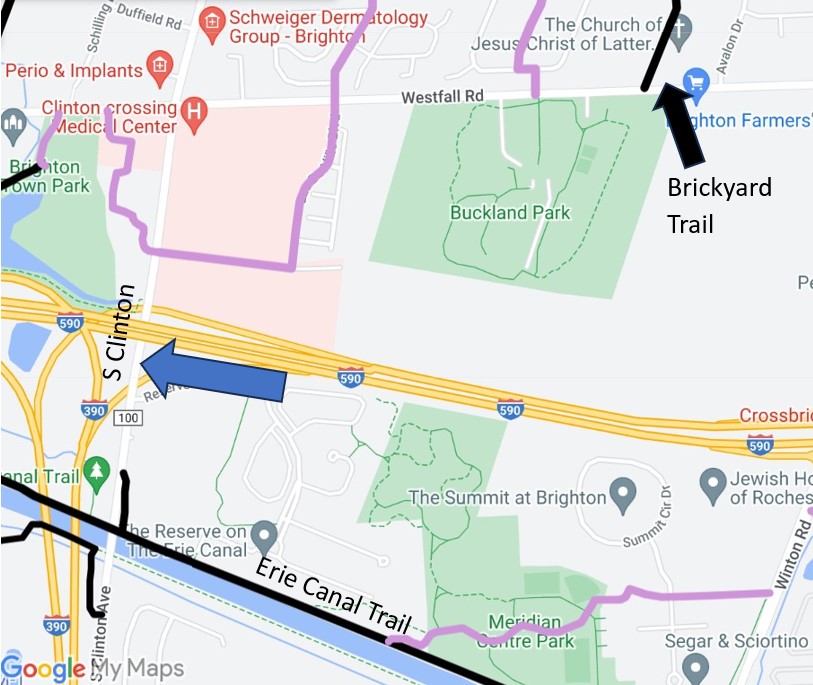
1. SOUTH CLINTON AVENUE OVER THE ERIE CANAL
Okay voters: we hear you! Brighton residents want to be able to bike from the Brickyard Trail and Buckland Park to Meridian Centre Park and the Erie Canal, but 590 stands in the way. Some dream of a bike/ped bridge over 590 (wouldn’t that be cool!), but this voting campaign is about short stretches and low-hanging fruit. Biking along Winton under 590 is way too uncomfortable for most bike riders. South Clinton, however, is more doable. How about protected bike lanes from Senator Keating Blvd to the parking lot beside the Canal? That’s only 4/10 of a mile.
Jurisdiction: Monroe County DOT
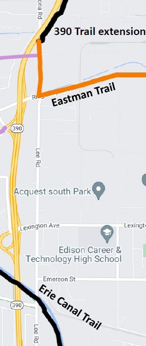
2. LEE ROAD CONNECTING ERIE CANAL TRAIL TO 390 TRAIL
Rochester’s west side is bereft of comfortable biking connections. It’s crucial that the 390 Trail and Erie Canal Trail be connected. A great start was made in 2022 with the new 390 Trail extension and Eastman Trail. Unfortunately, a NYSDOT project to construct a trail along Lee Rd from Ridgeway Ave to Trolley Blvd fell through. In the not too distant future, hopefully County DOT can give Lee Road a road diet and protect cyclists from that intimidating semi truck traffic. This stretch is 1.4 miles.
Jurisdiction: Monroe County DOT
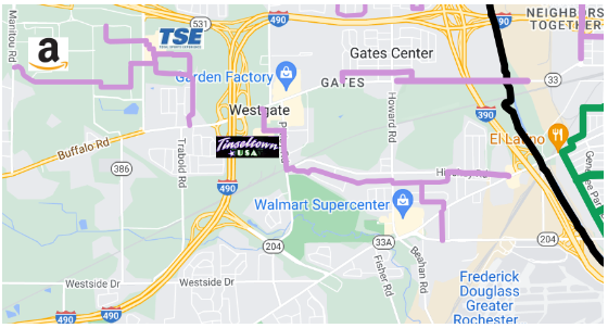
3. BUFFALO ROAD BETWEEN HOWARD & TRABOLD
Biking westbound out of the City isn’t easy. The average rider won’t be comfortable biking on Brooks or Chili Ave with their current configurations. The good news however is that once you bike past the Canal & 390, there are some residential streets that get you further west in a low-stress manner. Buffalo Road at least has bike lanes & wide shoulders until you approach Howard. The biggest wall then becomes 490. There’s no other way around it: Buffalo Road needs to be made bike-friendly going under 490. How about protected bike lanes along the half-mile stretch from Wegman Road to Davy Drive? Easy residential cycling then gets you to TSE, the Gates Library and the Amazon Fulfillment Center.
Jurisdiction: NYSDOT
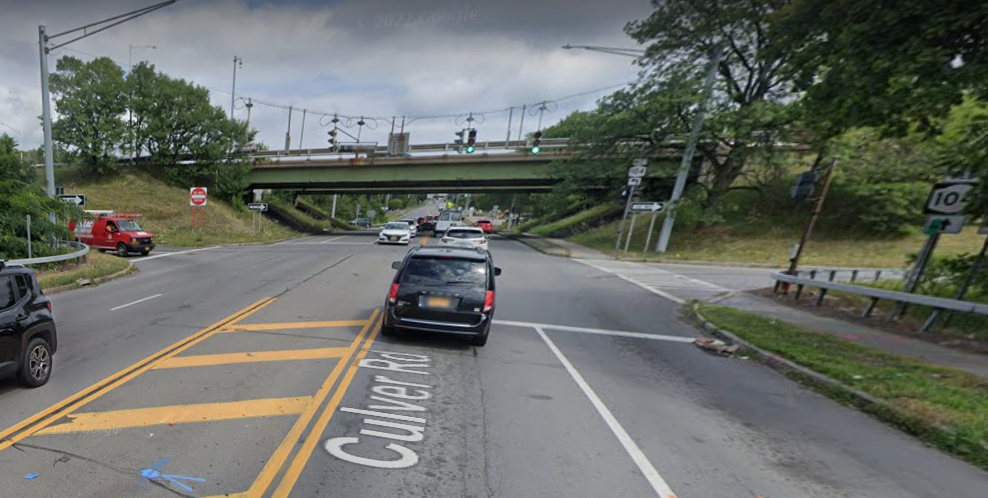
4. CROSSING 104 INTO IRONDEQUOIT
The easiest way to cross Route 104 by bike is via the El Camino Trail. But another low-stress route is needed to the east between Rochester and Irondequoit. Goodman and Culver are not friendly for cyclists. We see two options: Monroe County DOT makes the 104 underpass on Culver more bike-friendly, or the Town of Irondequoit explores this great trail idea put forth by Jack Rinaldo a couple years ago. Such a trail would only need to be half a mile long (!) and it would be transformative.
Jurisdiction: Monroe Co. DOT / Town of Irondequoit
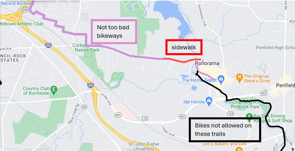
5. TRAIL ALTERNATIVE TO 441
As area cyclists know, biking on 441 is not comfortable at all. Riding a bike from the City to Penfield and southward to East Rochester is quite the challenge. Penfield Road east of 490 isn’t awful. At least there are shoulders to ride in. When those shoulders disappear after Poplar Drive, there’s a sidewalk/market parking lot/sidewalk again on the north side that will get you very close to Panorama Plaza. Behind Panorama Plaza, there is a trail network that gets you all the way to Perinton’s Spring Lake Park. But alas, adults aren’t allowed to ride their bikes on Penfield Trails. Remedying this gap would require the town to update its code. Pedestrians and cyclists can coexist on those trails right?
Jurisdiction: Town of Penfield
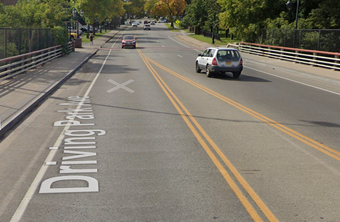
6. DRIVING PARK AVENUE BRIDGE
The City is starting a study to find the best way to fill the gap in the Genesee Riverway Trail north of downtown. As it is now, St. Paul Street bike lanes take riders north to Brewer Street, where the trail resumes over Middle Falls. (The Avenue A bike boulevard gets you here from the east as well). Those who don’t want to descend into the gorge only to climb back up to Driving Park Ave can avoid the hills & stay on flat terrain by taking Carthage Drive and biking on the Driving Park Avenue Bridge for a tiny bit. There are bike lanes on the bridge but motorist speeds are very fast and it’s quite an intimidating experience. How about protected bike lanes on this bridge, or a two-way protected cycletrack on the south side that takes you to the crosswalk and newly installed RFFB?
Jurisdiction: City of Rochester
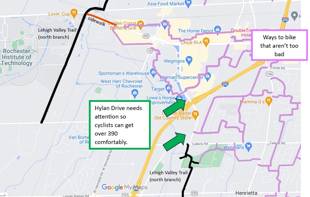
7. HYLAN DRIVE TO MARKETPLACE DRIVE
Parts of Henrietta (residential streets) are somewhat bikeable but 390 severs Henrietta in two. The north branch of the Lehigh Valley Trail is also severed in two. Perhaps someday Bailey Road, West Henrietta Road and Calkins will be made bike-friendly in order to really complete the trail’s north branch. But an easier lift would be giving Hylan Drive a road diet and really taking care to protect cyclists going over 390. Once a northbound cyclist gets to Marketplace Drive, they can veer off west or east for lower-stress biking. Where the trail ends at Calkins to Marketplace Drive is only 7/10 of a mile.
Jurisdiction: Monroe County DOT
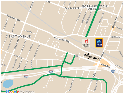
8. EAST AVENUE WEGMANS
Biking to the East Avenue Wegmans and locking up your bike next to the front doors is often way more convenient than driving there and searching for a parking space. But Wegmans could certainly be more approachable by bike in each direction. From the southwest, cyclists can ride along the comfortable Norris Drive or Harvard Street bike boulevards to Colby. There are new bike lanes on East Ave but unfortunately they don’t get you all the way to Wegmans. Surely something can be done too to connect the Harvard/Colby bike boulevard to the bike boulevard across from Artisan Works on Marion Street. That bike boulevard parallels Winton and goes up to Tryon Park. Many voters complain of how uncomfortable Winton is going over 490. This whole can of worms area needs attention.
Jurisdiction: NYS DOT (East Avenue) and City of Rochester (Winton and Blossom)
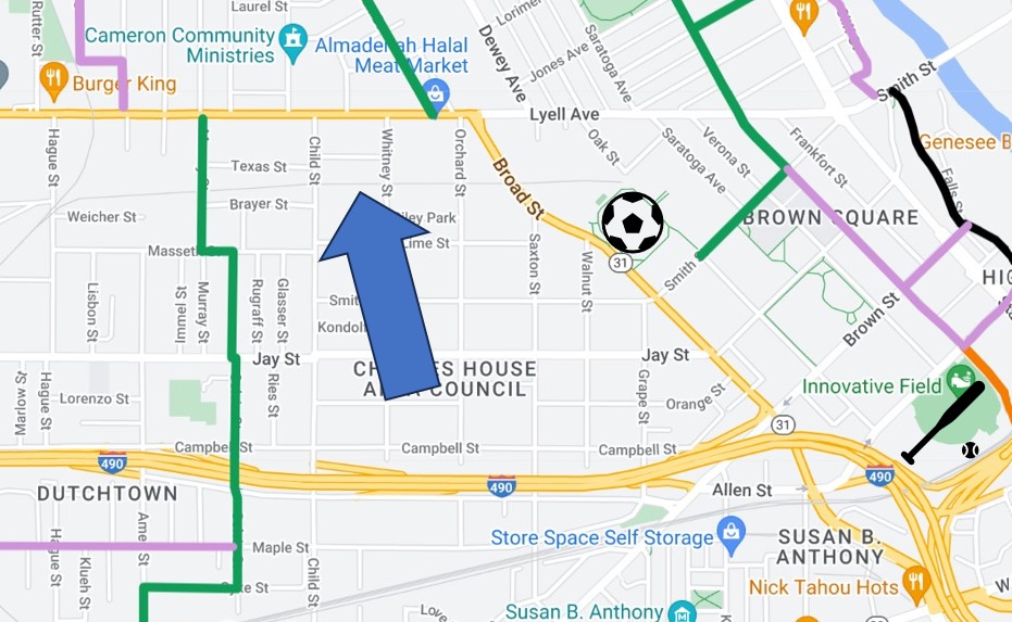
9. THE JOSANA TRAIL
A critical connection the City intends to make someday is between the Colvin Street bike boulevard and the soccer stadium, where the Plymouth bike boulevard continues north all the way to Kodak Park. This is especially important as this area sees a lot of cyclist-motorist collisions. The intended connection is via the abandoned railroad tracks and would be called the JOSANA Trail. Things always get complicated when acquiring CSX right-of-way is involved, but if this gap wins the contest, perhaps it’ll give the City a sense of urgency in acquiring right of way and finding the funding to implement the planning work that’s already done. This segment of the trail is only a half mile.
Jurisdiction: City of Rochester
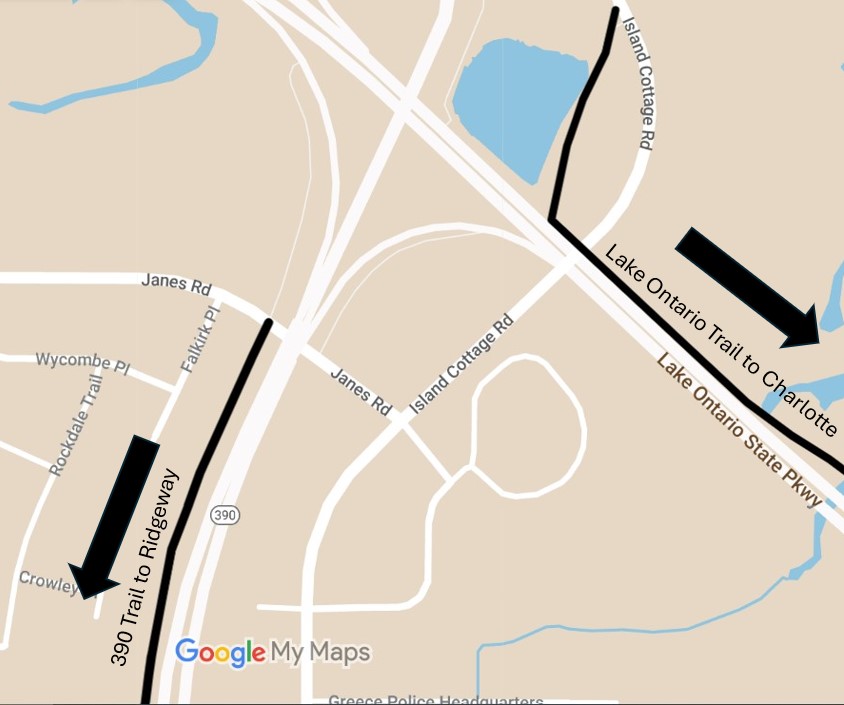
10. BETTER CONNECTION BETWEEN THE 390 AND LAKE ONTARIO TRAILS
Thanks to the new Eastman Trail and 390 Trail extension, Greece residents can bike along the 390 Trail almost to Mt Read Blvd, though the 390 Trail is in need of some serious maintenance. The 390 Trail goes all the way north to Janes Road, where some traffic negotiating is required. One has to take a left turn onto Island Cottage Road to where the Lake Ontario Trail starts. This little bit of shoulder riding is only half a mile between the two trails. The shoulders are quite wide but some all ages and abilities bike accommodations would be fantastic along that half-mile stretch.
Jurisdiction: Monroe County DOT
6. DRIVING PARK AVENUE BRIDGE Gets my vote.
The river and the soon-to-be state park are key draws to the area. From Bausch north to the lake there is no “at grade” crossing of the gorge that’s easy on bikers. The Seneca zoo bridge is problematic in slippery weather and not conducive to night or low light commutes. The middle falls is closed after hours and in the winter.
Driving park is a key connector both for commuting and for recreational biking that we can all hope will be centered around the river after the new park is established at high falls