Filling in the northern section of Rochester’s Inner Loop presents a rare opportunity to re-knit the fabric of a neighborhood that was unjustly damaged by the era of highway construction. And if we do it right, a newly designed landscape will bring new economic opportunity, better connectivity and accessibility, and improved quality of life for the people who live there.
As the planning process for Inner Loop North heats up, now is the time for all of us to be most active, engaged and vocal about what we want to see. We encourage you to attend one of the public meetings coming up on Dec 2, 6 & 7 (details here) to ask questions and give input on the latest designs.
For our part, Reconnect Rochester has been serving on the project Community Advisory Council for several years, weighing in at every opportunity to urge planners to create a connected community with streets and spaces designed for people (not just cars). A few months ago, we submitted written input to City officials and the project design team outlining our thoughts.
One thing we encouraged was for the City of Rochester to be open to creative ideas that come from the community. One big idea that’s been put forth is the High Falls Greenway, a concept developed by Jon Schull and Ben Rubin that has been endorsed by Greentopia, Hinge Neighbors & R Community Bikes. Their concept contains some stellar thinking and seriously creative ideas.
Here are Jon and Ben to tell you all about it…
Jon Schull 
Ben Rubin
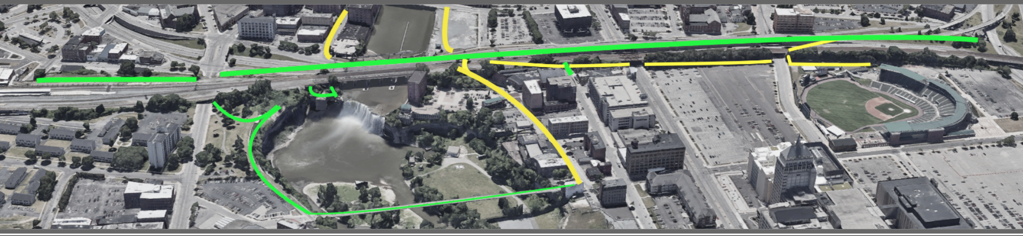
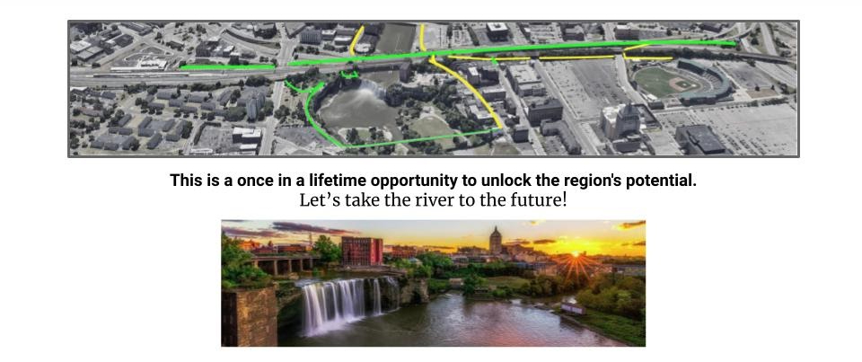
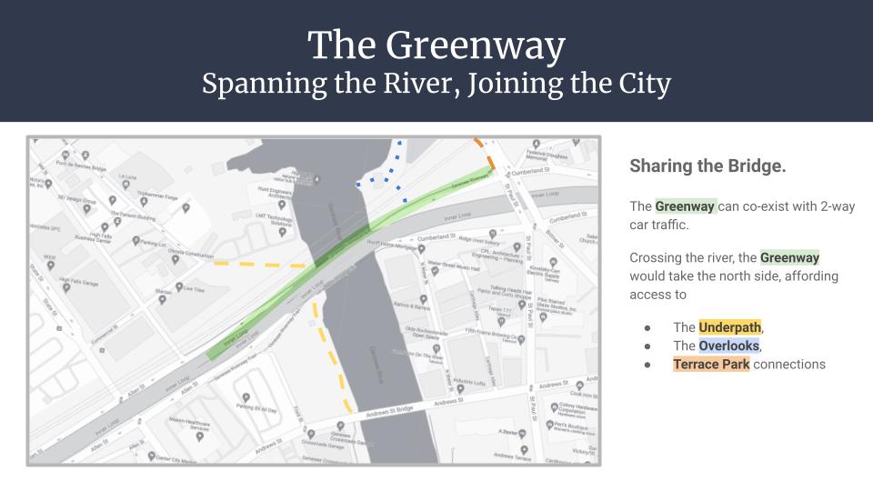
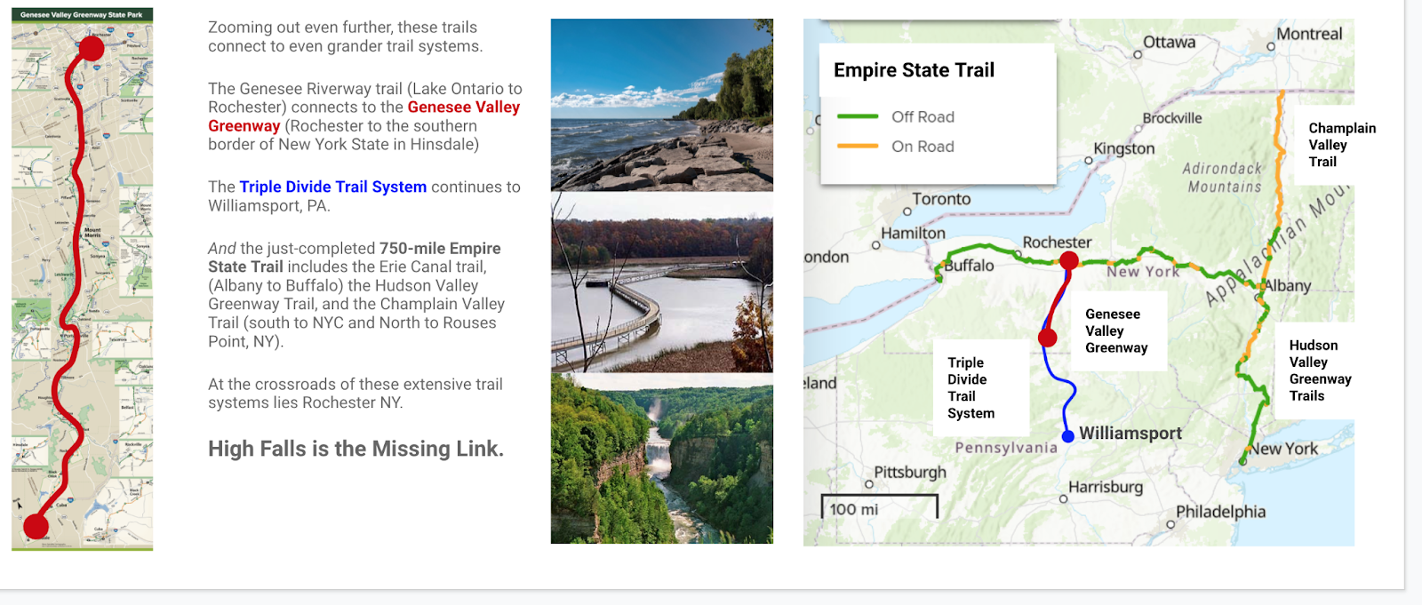
We need green, direct, car-free connections east-west across the river and north-south across the Inner Loop North. These connections can intersect and converge in a Greenway that overlooks the falls and provides functional and recreational active transport corridors that connect the downtown Riverway with High Falls, Frontier Field, and the Louise Slaughter Amtrak Station.
The Crossroads
Rochester faces a once-in-a-generation opportunity to redefine our city. Two massive urban development initiatives are underway; the ROC the Riverway projects traveling from south to north, and the east-west Inner Loop North project. Both converge at High Falls, where today an “overbuilt and underused” highway forms a pedestrian impasse obscuring one of the nation’s greatest urban waterfalls. As city planners and architects work to weave the Genesee Riverfront into “a direct trail connection to High Falls along the river,” we propose a greenway that would repurpose several lanes of the Inner Loop to fulfill the city’s aspirations. The High Falls Greenway could be the heart of an active transportation and recreational network spanning the state, advancing social equity, economic opportunities, and ecological wellness for generations.
“The successful transformation of the Inner Loop North will create new active and passive green spaces that promote multi-modal connectivity and accessibility, while also fostering opportunities for economic and community development.” – Inner Loop North Transformation Study, 2020
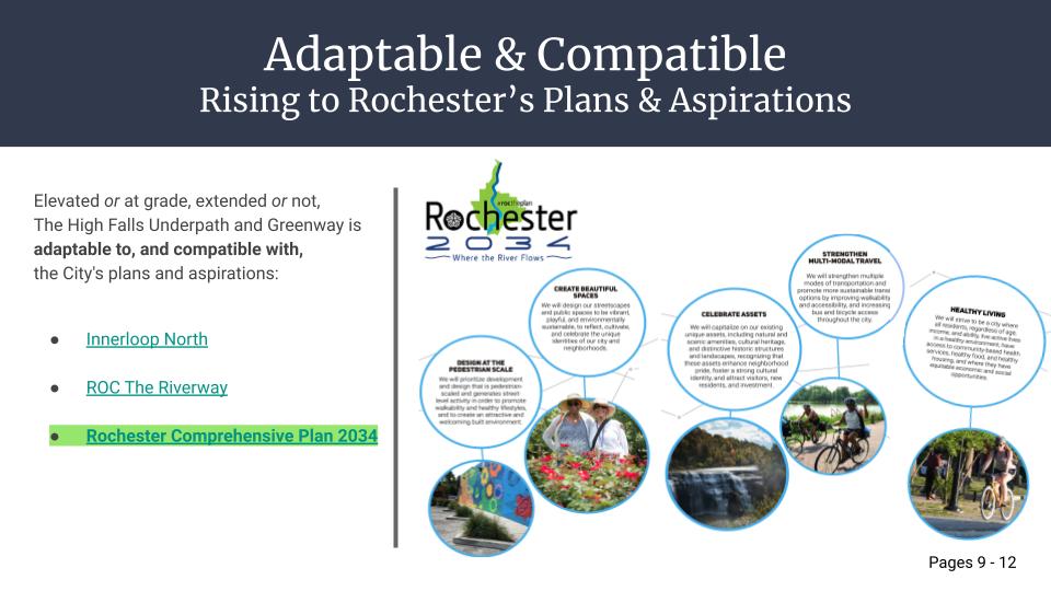
The city officials leading these efforts are forward-thinking advocates of active transportation, sympathetic to the principle that there should be car-free north-south and east-west corridors for pedestrians, bicyclists, tourists, wheelchairs users, and others who depend upon accessibility. A new administration, armed with funding and an ambitious 500 page Comprehensive Plan that maps Rochester’s aspirations for the next 15 years, can now turn big ideas into realities. But this can only happen with support from an informed and engaged public (that’s you!).
Rochester Raceway: A Retrospective

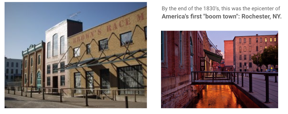
The City of Rochester, founded between a series of Seneca villages, began with a short canal called Brown’s Race. Built in 1815, the “raceway” channeled the Genesee to power flour mills at High Falls and became the epicenter of “America’s first Boom town.” Rochester’s population grew exponentially for a century, turning historical Haudenosaunee trails into roads for pedestrians and carriages, and adapted in the 1880s for bicycles. By 1900, Monroe County boasted the most extensive network of bicycle “sidepaths” anywhere in the nation with the same population it has today. Industrial giants, innovators and social activists like George Eastman, Glen Curtiss, and Susan B. Anthony all used these paths for their daily commute, along with 40,000 others.
But with the explosive adoption of automobiles, a new kind of race began, with roads prioritized for cars. Pedestrians were derided as “jaywalkers,” and bicycling (still the most energy-efficient form of locomotion in the known universe) became a second class form of transportation.
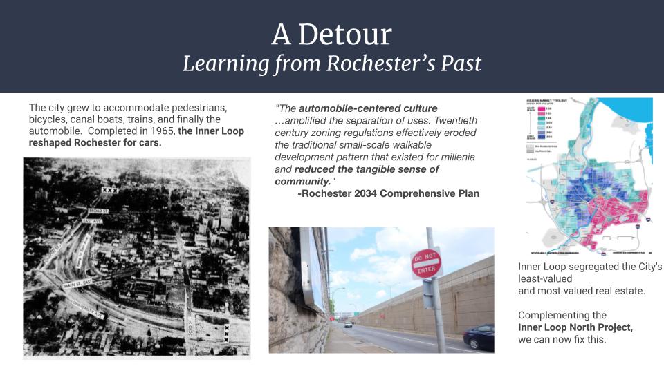
In the 1950s construction began on the Inner Loop, designed to facilitate high speed automobile and truck traffic at the expense of other forms of transportation. For a decade entire districts were progressively leveled to the detriment of newly-settled black families during the final years of the “Great Migration“. Rochester’s new automotive “moat” was largely impassable for pedestrians. Residences and walk-in businesses just yards beyond the Inner Loop margins were suddenly walled off from their neighbors. Intentionally or not, city neighborhoods were divided into two separate and unequal districts. As illustrated by the map below, the Inner Loop continues to segregate the city’s least-valued and most-valued real estate.
By the time the Inner Loop was completed, Rochester was a national model for shopping malls and suburban picture-perfect Americana while at the center of race riots in one of the country’s greatest concentrations of poverty. At the height of the nostalgic Instamatic years, our industry was paving over contaminated brownfields and our politics were downplaying racial discrimination.
Nevertheless, through social, economic, and environmental challenges, Rochester became home to adaptive and resistant communities: activists and immigrants, schools and hospitals, world-renowned musicians and deaf culture. Today, Rochester is defined by the storms it has weathered and by the diversity that has gathered along the riverbanks. Our long-constricted downtown is reintegrating into the larger Genesee River Valley, returning to the natural forces that powered the city growth.
High Falls Greenway
ROC the Riverway includes more than a dozen ongoing projects to improve access to the downtown riverway above and below High Falls. Inner Loop North, the next phase in our downtown highway remediation project, intersects the riverway and aims to restore the original street grid. Together, the projects are budgeted for ¾ of a billion dollars. They are interconnected and integral to the reintegration of Rochester; a critical junction in a critical moment.
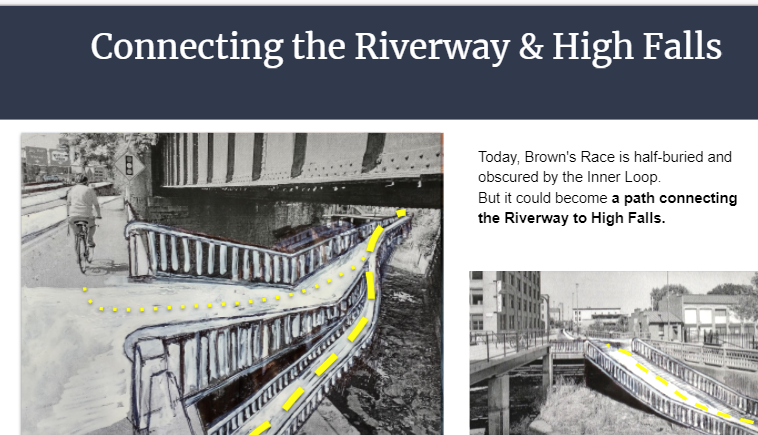
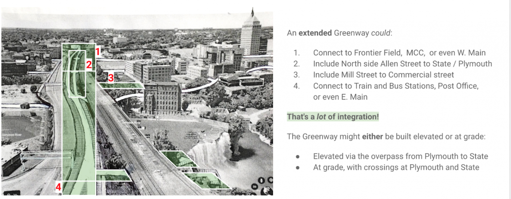
The city’s engineers have been examining Brown’s race as a potential portal to High Falls. They assured us that some kind of pedestrian through-path could be possible with the planned changes to bridge elevation. Also possible is a dedicated car-free greenway, which clearly aligns with the mission of the city. Our initial presentation offered active transportation considerations compatible with all of the city’s published plans. We are not architects or engineers, but as engaged citizens we did consider 490 connections, scenic overlooks, street integration, and a variety of extensions between West Main and East Main. Urban greenways have benefits beyond providing an alternative to automotive traffic – they can be socially transformative.
Establishing a fluid intersection between the river and the road would build community. Historically disconnected neighborhoods along the river would have front row seats to what would be our greatest tourist attraction, a revived High Falls district. Families from out of town could take the train to our new station and rent bikes to catch a game at Frontier Field, a contest at ROC City Skatepark, or a graduation at U of R or RIT. Residents could ride the greenway for regular commutes to school, jobs across town, or for shopping at the public market. Convention Center visitors, Constellation employees, and local students could stroll up the center of the city, sampling sights, sounds and fresh air from the falls. And for neighborhoods like the Hinge district, open access to equitable resources like bike and scooter stations would go a long way to reintegrating our city and engaging marginalized youth.
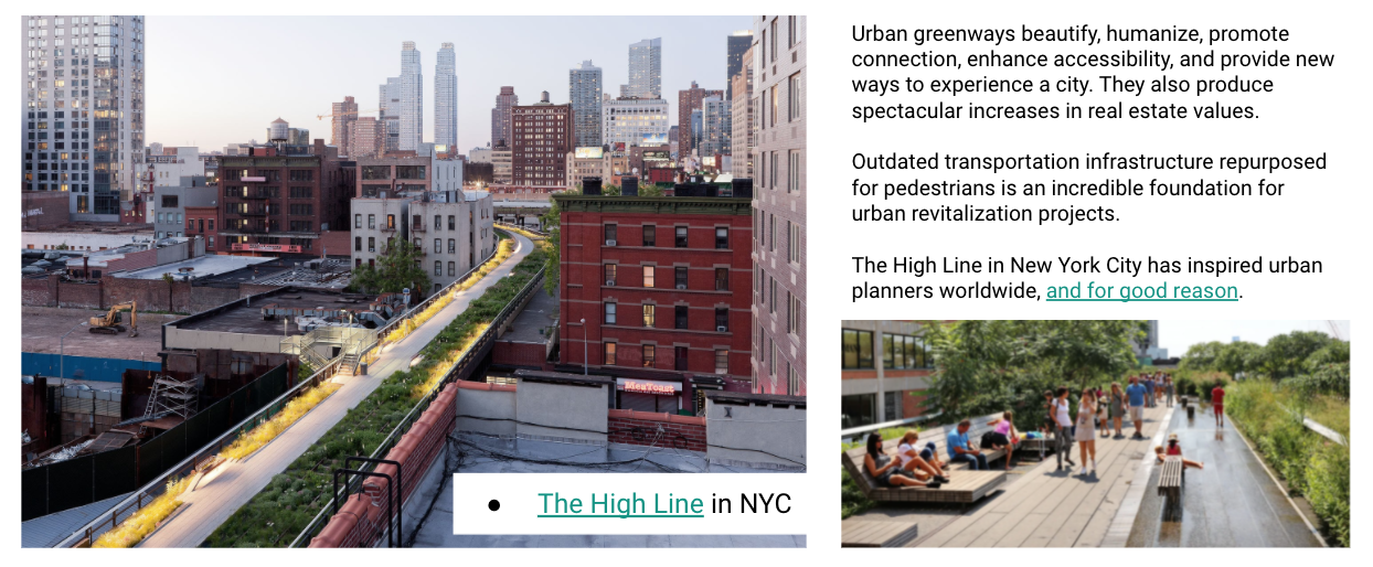
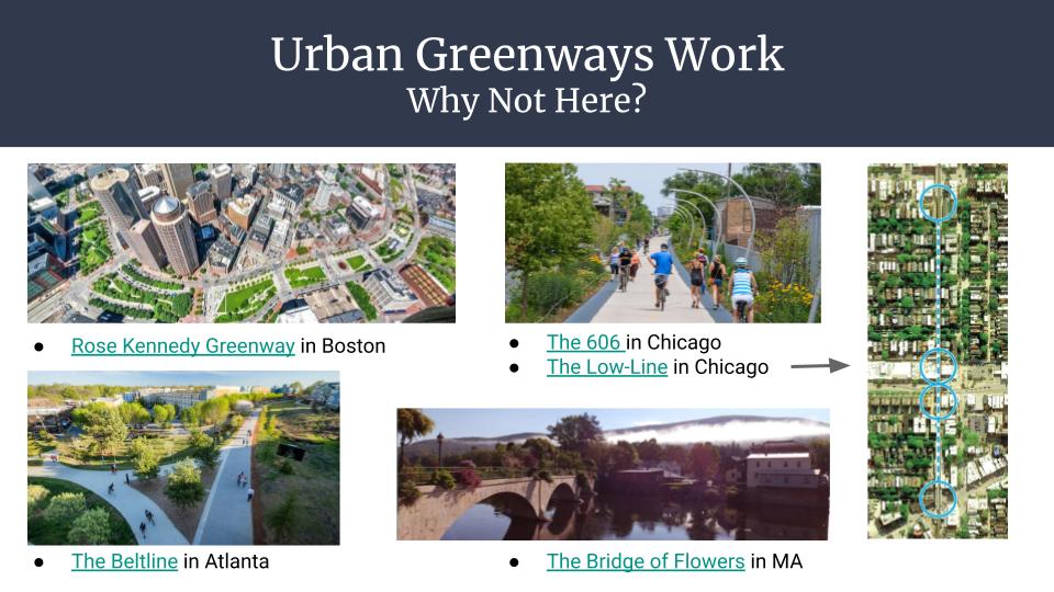
An integrated Riverway and Greenway converging at High Falls would provide spectacular returns on investment. During our meetings with city advocates, we learned that sections of the newly reclaimed Inner Loop territory are currently earmarked for high density, high value housing. But that is not the only way to increase value. New York City’s investment in the High Line, which turned the stagnant meatpacking and Chelsea districts into attractive residential, business, and entertainment zones, has recouped 900% in tax revenues alone while maintaining dedicated greenspace for active transit. From Chicago to Atlanta, it is widely documented that greenways pay.
And then there are the benefits to ecology and health. A city optimized for human powered transportation becomes cleaner, more efficient, and more livable for humans and our ecological co-inhabitants. Rochester’s river, waterfalls, gorges, and park paths blend with our existing network of tree-lined streets, bike boulevards, and statewide trails. With so many existing natural resources defining the city, we all benefit more by planning with the natural systems we rely upon.
The city is collecting feedback from residents to correct some of the past mis-steps and to create lasting opportunities and livelihoods for future generations. City Hall won’t be carrying all of the responsibility alone. Families and schools, businesses and organizations, entire neighborhoods can stand together and remain vigilant to ensure that the city’s laudable vision and well-defined aspirations are preserved.
Rochester’s past, present, and future converge at High Falls. A greenway that fully integrates the east and west sides of the river would transform the way the world sees Rochester and the way we see ourselves.
If you support a downtown greenway, spread the word. Get your neighborhood association to join those that have already endorsed the proposal. Post on social media. Join our facebook group. Talk to your representatives. And stay tuned.
View the complete High Falls Greenway Proposal