If you’ve ever navigated the world without a car (whether that be for necessity or recreation), you’ve probably had a, “Why can’t I get over there from here?” moment. Guest blogger, Jack Rinaldo, had so many of these “moments” that he actually wrote up a proposal for a new mixed-use trail in Irondequoit, which would connect the eastern edges of Norton Street and Ridge Road. Curious? Read on for the nitty-gritty details in his own words.
Guest Blog by Jack Rinaldo
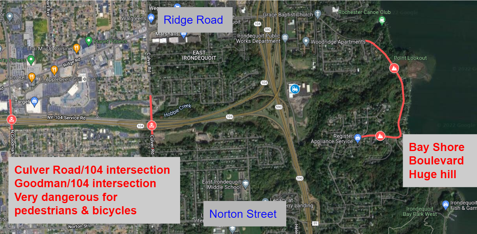
If you want to walk or bike to or from Southeast Irondequoit, you need to cross 104. There are only three locations to do so, highlighted in red in the picture below. Goodman Street and Culver Road have intersections with on/off ramps for 104. Both of these locations are dangerous for pedestrians and cyclists, no matter if they are on the road or the sidewalk. The other option is Bay Shore Boulevard. This street is calm, but it has huge hills at either end of it, making it unusable for most people.
These barriers cut off the southeast side from the rest of Irondequoit. Would you let your kids use any of the three current routes? I am an experienced and confident cyclist and I will not ride on those sections of Goodman or Culver.
The proposed new trail would run from Norton Street north to Ridge Road. As seen in the picture below, the trail would start just east of the Norton Street/590 onramp. The trail could run very close to the 590 onramp, similar to the Brooks Avenue/390/Erie Canal Trail setup as shown below. It would then run north, connecting with the road that the new Irondequoit town Department of Public Works (DPW) is on. This half mile section would potentially be the only new construction needed.
Once connected to the DPW road, trail users could use that road to reach Ridge Road. Additional sections of trail to the side of the road could be added as well if they are determined to be needed.
This trail would be similar to other local trails near highways such as the Route 390 Trail in Greece, and the Route 104 Trail in Webster.
This new trail would easily connect to the Sea Breeze Drive trail as seen in the picture below. Once at Ridge Road, trail users go 1000 feet west to Kane Drive. Kane Drive is a nice calm street. Once at Kane Drive, they would proceed north until they met the Sea Breeze Drive trail at the Titus Avenue roundabout.
The new trail would also easily connect to the City of Rochester’s Bicycle Boulevards. Heading south, traveling 700 feet west on Norton Street brings you to Helendale Road. Helendale Road is another calm street. Once in the Laurelton neighborhood, use Spencer Road and Whittington Road to directly access the Bicycle Boulevard system on Farmington Road.
To connect the new trail to the other systems above, all that would be needed would be signage directing users along the route.
The newly expanded trail system would also connect all six of the schools in the East Irondequoit School district. Students and families could use the trail to access school facilities for class and extracurricular events.
- Irondequoit High School is 400 feet from the Kane Drive/Ridge Road intersection, and a path to the school’s athletic facilities is on Kane Drive.
- East Irondequoit Middle school is 1200 feet west of the Norton Road/Helendale Road intersection, then 500 feet up Densmore Road.
- Laurelton-Pardee Intermediate School is 1700 feet from the Norton Road/Helendale Road intersection.
- Helendale Road Primary School is directly on Helendale Road.
- Durand-Eastman Intermediate School is almost directly on the Sea Breeze Drive trail.
- Ivan Green Primary School is 1 mile away by safe neighborhood roads from Kane Drive.
The newly expanded system would connect many parks such as Irondequoit Bay Park West, Tryon Park, Durand-Eastman Park, the Lakeside Trail, SeaBreeze Amusement Park, Irondequoit Bay State Marine Park, and the beach at the Irondequoit Bay outlet.
Here is a link illustrating the new trail and it’s connectivity to the town: https://www.google.com/maps/d/edit?mid=1CTSRzSTvziHLSrxeJaSAt5wvJEjHc9Sd&usp=sharing (best viewed with Google Maps’ cycling layer turned on)
Irondequoit can look at the successes other towns have with trails, such as the new Brickyard Trail in Brighton, as well as the continued use of miles of trail that already exist in the region. Creating the new trail would be a great opportunity for the town to take unutilized land and better connect residents and neighborhoods, while promoting healthy and environmentally friendly transportation. The half mile of construction needed to achieve all of this would be very worth it.


