No Comments

Bike Access to Nature

By Jesse Peers, Cycling Manager at Reconnect Rochester

I say this on my history bike tours a lot: If I could temporarily time travel back to one decade, it’d be the 1890s. In this decade, the up ‘til then economy-minded City of Rochester started a massive investment in the public realm: it developed its world-class park system and with the electrification and extension of the trolleys, residents could hop on a streetcar and visit our parks and beaches at their leisure. The 1890s is also renowned as the greatest bike boom in history and automobiles hadn’t yet dominated our streets.

Bike History Books
Rochester’s bike history is featured quite prominently in these four recent books

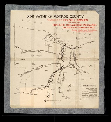
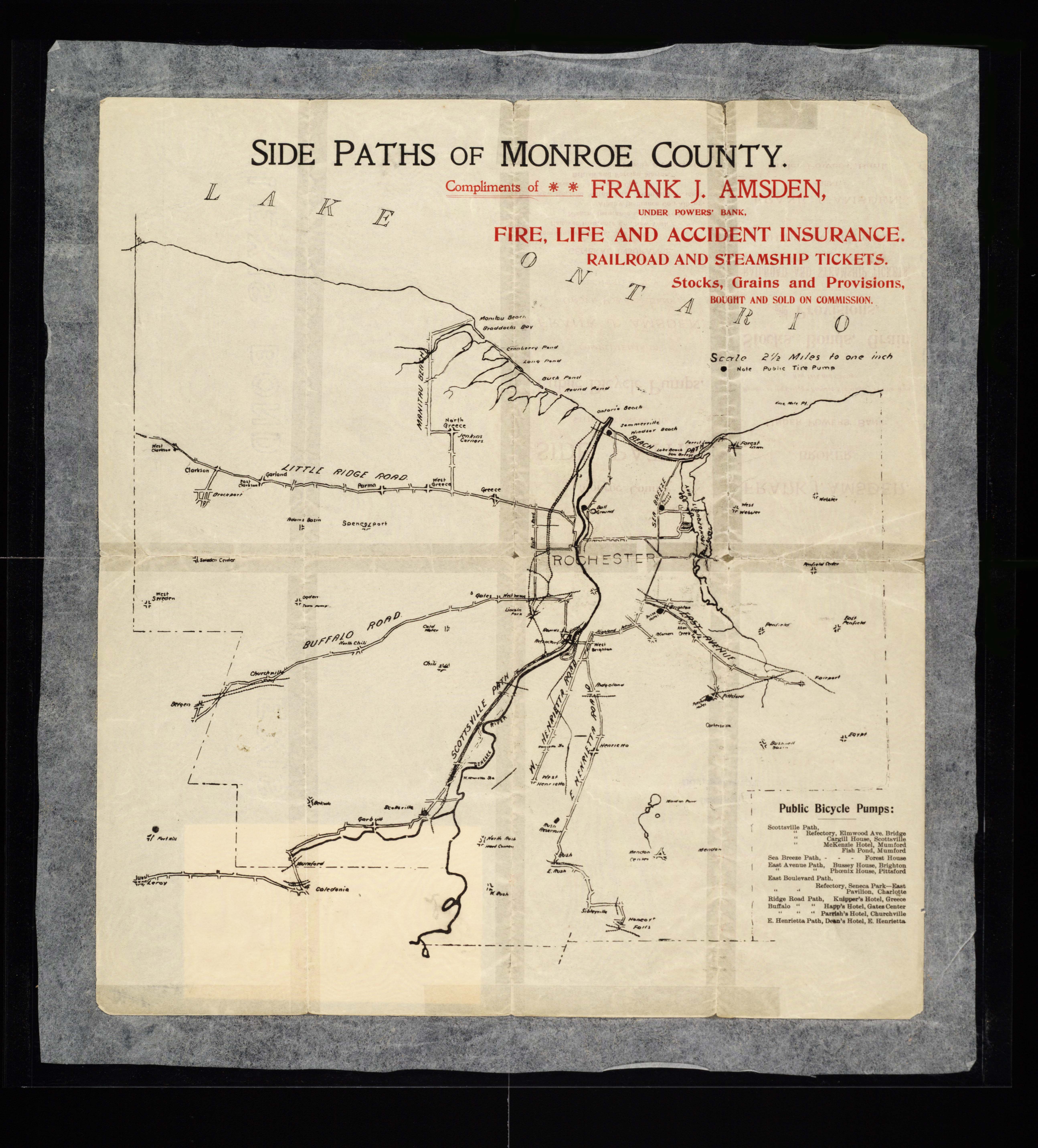
One of the bicycle’s greatest selling points at the time was the ability to access these newly developed parks and to escape the city into nature whenever you wanted. The world was at your fingertips – just a short pedal away! In the early twentieth century, Rochester cyclists would make that access to nature and the surrounding countryside even easier by pioneering a system of sidepaths through Monroe County. For a while, cyclists came to Rochester from afar to see top-notch bike infrastructure!

In Rochester’s early days, the city center was surrounded on all sides by “verdant nurseries and blooming orchards.” Visitors to the Flower City were awed by the “seemingly endless acres of blooming rose bushes, tulip beds & fruit trees, encircling the city.” Before those areas were taken over for housing, Rochester’s early Parks Commissioners proposed a park boulevard 300 feet in width encircling the city with a number of small parks scattered along its route. Instead, priority was given to two large parks straddling the river: “South Park” (Genesee Valley Park) and “North Park” (Seneca Park).

That original idea, though, kept resurfacing as subsequent mayors toyed with the idea of connecting the growing park system. Like many, we are mesmerized by this 1911 vision for Rochester. Because Rochester’s large parks were “comparatively remote,” planners felt their usefulness could be “much enhanced by narrow, extending arms reaching out into the surrounding territory and forming park-like approaches to them.” These connective parkways  would “multiply in effect the extent of park area conveniently available to the community.”

Map of Rochester

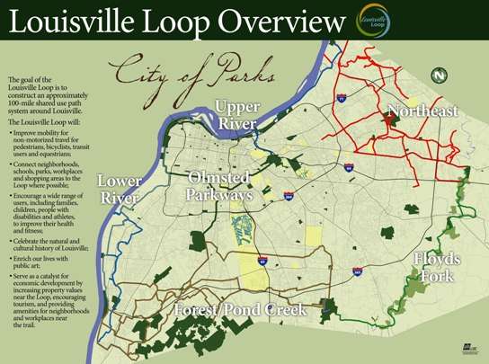
Sadly, the costs were too prohibitive and the project was dropped. (Two small beginnings though were made towards its realization: Seneca Parkway in Maplewood and Genesee Park Boulevard in the 19th Ward). For an example of a peer city that got much closer to achieving a similar vision, check out Louisville, Kentucky.

Louisville Loop Overview
Though they are still working towards its full realization, Louisville, Kentucky’s Olmsted Parks are connected with Parkways. Learn more about the Louisville Loop.

With another bike boom happening, the recent adoption of Rochester’s Children’s Outdoor Bill of Rights, the expansion of the City’s Bike Boulevard network, and the simultaneous creation of Active Transportation Plans for the city and county, we thought it a good time to revisit this concept of bike access to nature and our parks. Using the 1911 vision as our guide, let’s examine our modern bike network as connective tissue to our stellar parks.

Rochester's Children's Outdoor Bill of Rights

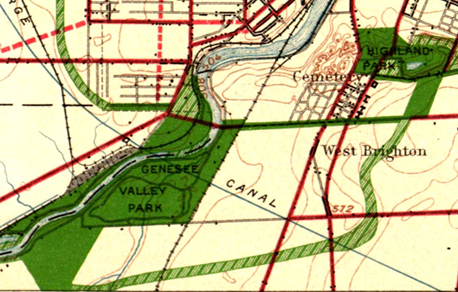
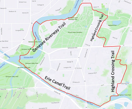
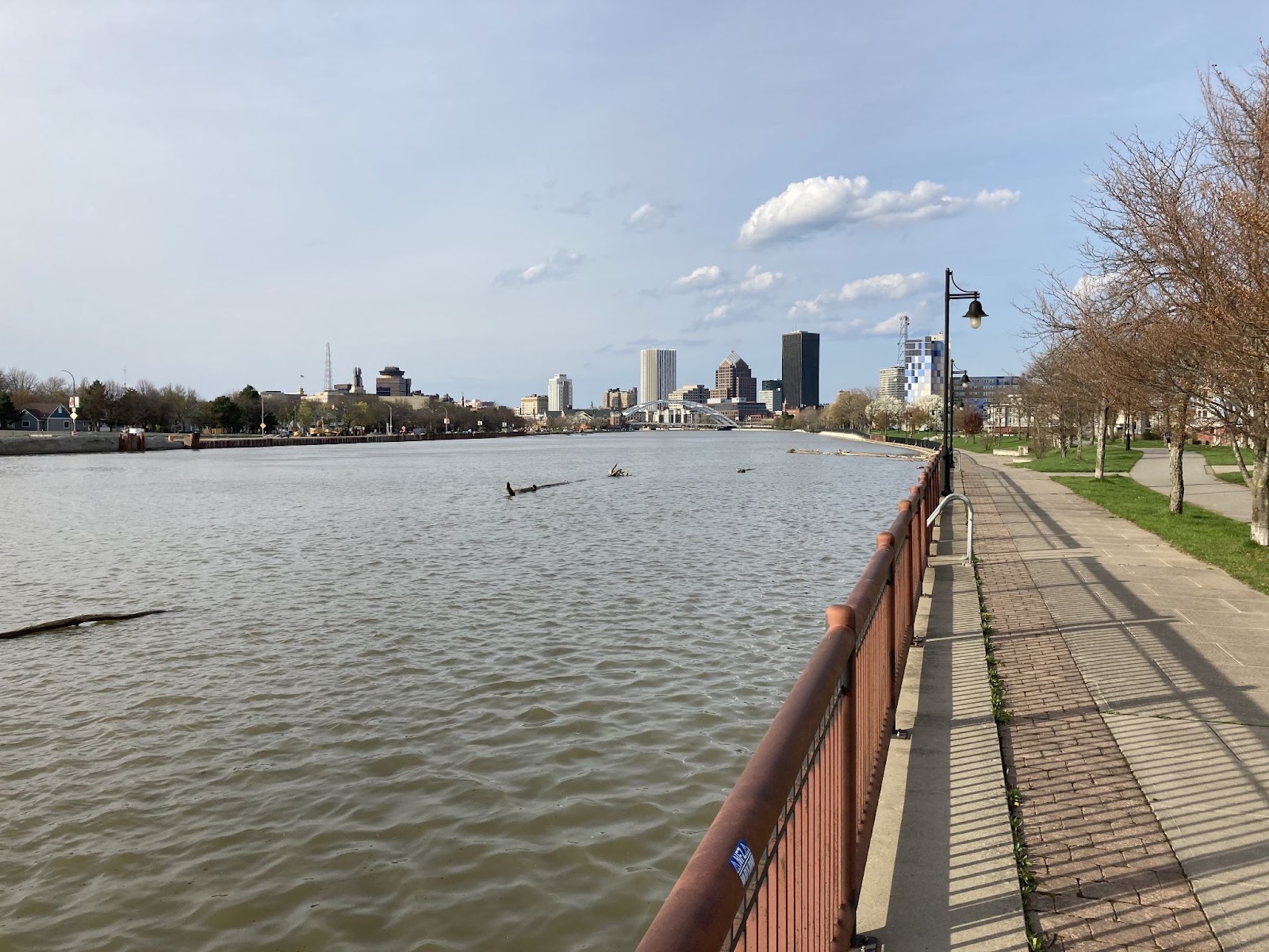
The Highland Crossing Trail, which many residents don’t know about since it hasn’t been incorporated into Google Maps’ bike layer yet, was a unique collaboration between Brighton and Rochester. With the Erie Canal Trail, it connects Genesee Valley Park to Highland Park. These trails together with the Genesee Riverway Trail make a wonderful seven-mile recreational loop we recommend you try sometime.

Bike Route Map
Bike Route Map

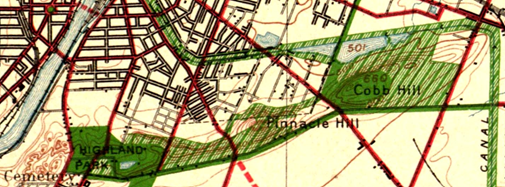
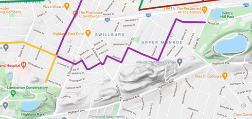
Recurrent calls in the early twentieth century to secure the Pinnacle Hills as parkland connecting Highland Park and Cobbs Hill Park were unsuccessful but today’s Bike Boulevard through Swillburg and Upper Monroe does a good job of connecting them.

Bike Route Map
Bike Route Map

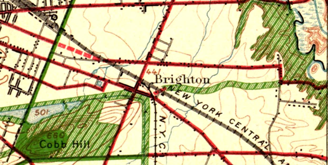
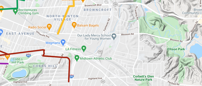
Connecting Cobbs Hill to Irondequoit Bay and what is now Ellison Park is harder. The 1911 planners called for an extension of Richs Dugway Road but today’s railroad tracks present a significant barrier, as does the area around Wegmans and the “Can of Worms” interchange. For now, Browncroft Blvd, Blossom Rd and Highland Ave can be used. Living in the Culver and Merchants triangle, my kids and I are a 10 minute bike ride away from Ellison Park – a ride we cherish, especially in the Fall. We turn off of Browncroft onto Shaftsbury and Corwin Roads for a low-stress approach to the Park.

Bike Route Map
Bike Route Map

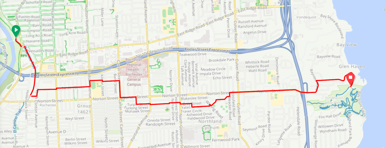
Though a parkway or trail extending east to west “along the low land just south of the Ridge Road” and today’s 104 isn’t possible, the El Camino Trail and the new Bike Boulevard through 14621 can connect Seneca Park to Irondequoit Bay.

Bike Route Maps

To connect the Genesee River and Seneca Park to Durand Eastman Park, the 1911 plan called for a connection westward “up one of the little valleys” to the northerly end of Seneca Park. Check out this creative route by Pam Rogers.

Bike Route Maps

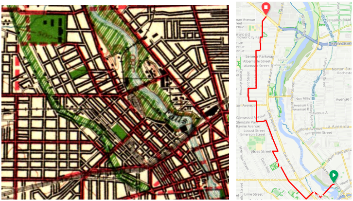
To connect downtown with Edgerton Park and further north, we all know Lake Avenue must be avoided at all costs by bike. But the new Bike Boulevard along Plymouth parallels Lake Avenue and gets you all the way up to Kodak Park in a low-stress manner through the gorgeous Maplewood neighborhood.

What are your favorite low-stress ways to visit nature by bike? Let us know! If you agree with the Children’s Outdoor Bill of Rights declaration that every Rochester child should be able to “safely explore their community green spaces” and nearby parks, we’d ask you to advocate for continuous, high-comfort bike infrastructure for all ages and abilities for the City and County’s Active Transportation Plans this year.

5 Comments

A Naturalist’s Ode to Urban Density

Guest blog by Doug Kelley, Associate Professor at University of Rochester

I grew up doing a lot of hiking and backpacking in the woods of Alabama. Being outside connected me to a world that seemed more fundamental, more enduring, less corrupted by the mistakes of humankind. I felt empowered by the ethos of backpacking especially, that my own two feet could take me through the world from one beautiful place to another, and when I was gone, I would leave no trace, so others might enjoy the same beauty. I could forget daily stresses in favor of long conversations with friends, basking in sunshine and endorphins. I was (and am) a naturalist. I chose a college in the Appalachian mountains, and spent summers back in the Alabama woods, a counselor at Camp McDowell, quick to volunteer to lead kids on hikes.

Over time, my passion for being outdoors led to an idea that seemed surprising at first: for a naturalist like me, who wants to spend as much time outdoors as possible, the best place to live is not in the woods but in a densely-packed city center. Urban density allows me to live close to my workplace and commute by bike or public transportation, so I’m outdoors for an hour every day, routinely, without committing extra time. Urban density means there’s a small market a block from my house, a pharmacy two blocks beyond, a library within five blocks, a hardware store and supermarkets easily accessible by bike, and a huge number of restaurants, cafes, bars, and coffee shops nearby. In a city center, sidewalks and bike lanes and bus routes offer dense connections. When traveling to all these places and more, I can be outdoors, enjoying the same sunshine and exercise as on those Alabama trails, years ago.

Headed home from work on the River Trail, I enjoy fantastic views of downtown Rochester daily. (Credit: Doug Kelley)

Without urban density, neither I nor my neighbors — who I see often on sidewalks and porches — could benefit from so many amenities. If lots were bigger and residences weren’t arranged with as much density, our destinations would be pushed further away, often too far for walking or biking. In fact, many destinations would cease to exist. Markets and restaurants and shops are businesses that rely on having enough feet cross their threshold daily. Urban density puts customers close. Or, from the customers’ point of view, urban density puts businesses close.

A naturalist’s first instinct might be to live far outside the city center, near trails and hills and streams. Wistfully I can imagine myself stepping out of a house abutting Mendon Ponds Park, a favorite place to ski and hike and cycle, ready to start an outing without even getting in a car. But to gain that privilege, I would have to trade away countless hours of outdoor time enabled by my city life. Living by those trails, I’d be cooped up in a car every time I commuted, every time I needed groceries, every time I wanted a restaurant meal. RTS buses don’t go that far out. Altogether, that life would allow me far less time in the outdoors I love. Much better to drive to the trails and live in the city.

A favorite hiking destination at Camp McDowell was St. Christopher’s Pool, at the head of a canyon and beneath a waterfall near the edge of the property. But in those years, St. Chris’s was badly defaced, its rocks and water turned a sickly shade of orange by runoff from the coal mine upstream. The Rev. Mark Johnston, executive director of Camp, waged a legal battle that ultimately brought the mine’s owners to remediate the stream, largely restoring St. Christopher’s. Mark also reminded campers and staff often that though the mine owners were culpable for property damage, all people are responsible for being good stewards of shared resources, and we ourselves contributed to the damage when we used the electricity produced by that coal. It was a tough lesson, and an important one.

That lesson, too, leads naturalists to value urban density — because it seriously reduces our own contributions to the human damage of natural places. New York City has the highest population density of any large area in the United States, with 27,000 residents per square mile. New York City also has a vastly smaller per-capita carbon footprint than typical American places: in 2015, an average resident produced emissions equivalent to 6.1 metric tons of carbon dioxide, less than a third of the national average of 19. Likewise, an average New York City resident uses far less energy and produces far less waste than an average American. It’s no coincidence that urban density reduces carbon footprints, energy use, and waste. Density enables car-free transportation, which burns little or no fossil fuel. Density also makes residences more efficient, because apartments are insulated by their neighbors, and because smaller residences almost always require less heating and cooling. And as anybody who’s cleaned out their garage knows, having more space inevitably leads to accumulation of more stuff — not all useful!

Reflecting more deeply, the lesson of stewardship and the naturalist’s leave-no-trace ethos are fundamentally about equity, and urban density promotes equity, too. Beyond leaving natural places untrammelled and less-damaged by climate change, density makes healthy and pleasant lifestyles available to all, even those who never spend time in the woods, either for lack of interest or for lack of opportunity. Regardless of social and economic status, almost everybody can walk and bike, which opens a myriad of possibilities in a well-designed city center. Public transportation is more broadly affordable than personal automobile ownership. And density matters even more for people with disabilities, for whom nearby amenities are no mere matter of convenience.

Rochester, NY (Credit: Joe Wolf on flickr)

Obviously, Rochester is not as dense as New York City, but at 6100 residents per square mile, its density exceeds many American cities, including Austin, TX (3200), Cleveland, OH (5100), and even the famously bike-friendly Portland, OR (4800). Most of Rochester proper and some suburbs boast sidewalks and gridded streets, making walking and biking easier and more enjoyable. Gems like the Canal Path and River Trail connect pedestrians and cyclists to more amenities over greater distances. Regional bike infrastructure is being steadily improved and expanded. Many neighborhoods in our region are great places for the urban naturalist lifestyle.

Some of Rochester’s density was automatic, because the city predates personal automobiles. But now, building and maintaining people-friendly city centers requires conscious choices, good policies, and ongoing input from citizen-naturalists. Reconnect Rochester has made major efforts to encourage urban density and make outdoor city life more pleasant and equitable. The work continues, and you can help. For starters, Rochester’s zoning laws have put limits on density, but are now being reviewed for revision, so leave a comment supporting urban density. Urge leaders to implement and expand bike master plans. Nearly every local municipality has one, thanks largely to the Rochester Cycling Alliance (for example, see the City of Rochester plan). Or get involved with Complete Streets Makeover for hands-on projects making outdoor urban spaces more practical and beautiful. Get plugged in to Reconnect Rochester’s work so you can learn about opportunities to volunteer for hands-on projects, attend public meetings, sign petitions, and be part of the effort.

The tulip trees on Oxford Street are among the many everyday delights of my bike commute, made possible by urban density. (Credit: Doug Kelley)

In the end, my bike commute may not have the same grandeur as summiting one of the Adirondack High Peaks, but doing it every day makes it more important to my life, health, and peace of mind. On the River Trail in the morning, I see groundhogs and rabbits frequently, and also deer, turkeys, hawks, and occasionally a fox or heron. In the afternoon, I enjoy a grand river vista of the Freddie-Sue Bridge with downtown buildings towering beyond. For one precious week every spring, I revel in an explosion of color when the Oxford Street tulip trees bloom. And knowing that urban density not only helps me enjoy the outdoors, but also helps me leave no trace and allows many others the same benefits — that makes these natural experiences sweeter still. 

No Comments

Pave and Plow: The Next Standard For American Trails

Written by Arian Horbovetz and originally published on The Urban Phoenix blog

I’m pleasantly surprised with the amount of trail creation that is occurring across the United States. Urban paths, trails from former railroad beds, and neighborhood connectors… people are hungrier than ever to explore a new pedestrian or cycling experience. And for those like me, the ever-growing network of trails that can potentially remove us from the dangers of automobile encounters is so incredibly vital.

But as always, I’m going to challenge our townships, counties and cities to think bigger. I’m not spitting in the face of real progress, I’m asking everyone, especially in our denser communities, to consider two standards with regard to trail creation, use and maintenance going forward.

Pave Your Trails

I am so proud of my home city of Rochester and the surrounding towns for making trail creation a priority. There are so many new trails that have popped up in our area, and it’s truly a testament to a handful of amazing people with great vision for healthy recreational use and sustainable transportation. But most of these new trails are unpaved “cinder paths.” While cheaper to construct, they are far less convenient for thin-tire bikes such as road bikes and fix-geared bikes. Furthermore, the new rage of electric micro-mobility (e-scooters, e-skateboards, etc.) has the potential to change the way we move about our communities. But most of these vehicles have small, hard, unforgiving wheels that perform poorly on unpaved surfaces.

For many who are reading this, the response to the sentence above may very well be “GOOD!” The pushback against electric micro-mobility is substantial. But my take is that anything that gets Americans out of their cars is positive. If you want to retain young people in your community, allow for the recreational and practical proliferation of electric micro-mobility. Build for a community that welcomes as many forms of transportation as possible. Only then will a mobility-progressive future be possible.

Plow Your Trails

This is a message specifically directed at northern states that receive significant snowfall. Creating trails that are unusable for 4-5 months during a year is, frankly, a denial of the potential for trails to be year-round public resources for transportation and community health.

Paved trails can be plowed easily, providing local residents a year-round outlet for exercise and safe mobility. In the Greater Rochester New York area, the Empire State Trail (Erie Canalway Trail) is partially paved, but goes unplowed during the harsh winters that can see upwards of 100 inches of snow. The brand new Highland Crossing Trail, which I happily take every day to get to work, is unpaved and unplowed, forcing me onto the busy streets on my bike during the winter months. Again, I appreciate my local governments for being proactive in creating a community resource. I do, however, blame a century of one-dimensional transportation prioritization in the United States that has created the belief that the only way to practically access jobs and resources in our community is via the automobile, the most exclusive, unsustainable and individualistic form of transportation available.

If we truly acknowledged the importance of inclusive mobility, we would readily pave and plow all of our trails, new and old. But as of now, we as a culture would rather see trail creation as a seasonal recreational nicety instead of a legitimate year-round alternative transportation solution. This must change with regard to the future of mobility in our country.