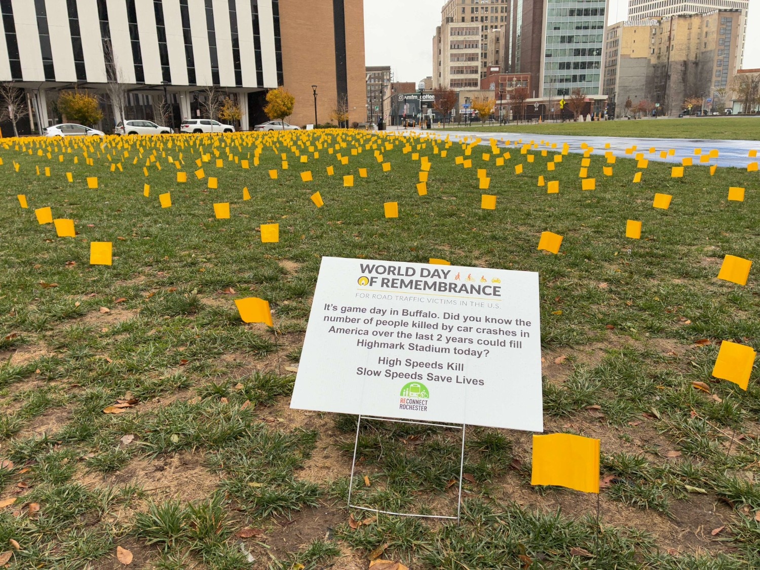
Thank you to all who joined us for the World Day of Remembrance for Road Traffic Victims on Sunday, November 16th. Together we remembered those we have lost, support victims and their families, and discuss ways to act to improve road safety. We also launched an updated Monroe County Crash Map to identify trends regarding bike and pedestrian crashes on our local streets.
The World Day of Remembrance is an international effort to remember, support and act to prevent car crashes, injuries and fatalities. Every year, millions more road victims are added to the current toll of over 50 million killed and hundreds of millions injured since the first road death. As roadway deaths remain at crisis levels, with 40,990 lives lost in U.S. traffic crashes in 2023 and more than 2.7 million people sent to emergency rooms, WDoR offers a powerful chance to raise public awareness and demand real solutions. The U.S. continues to have the highest rate of traffic deaths among 27 high-income countries, underscoring the urgent need for systemic change and a reminder that safer streets are possible.
Our Advocacy Ask for 2025:
Safe Speeds Save Lives and lowering speed limits can, alone without any other intervention, reduce crashes and improve survivability. Therefore we are advocating for the City of Rochester and towns and villages in Monroe County to adopt 25 MPH area speed limits on roads under their control before the end of 2026.
THANK YOU to all who joined us on August 22nd, at 5:30PM at Parcel 5 outside Senator Jeremy Cooney’s office. We were proud to send a strong message to New York State Department of Transportation that we need safer infrastructure on state controlled roads such as W. Henrietta Rd, Monroe Ave, Lake Ave, and Empire Boulevard.
The Monroe County Active Transportation Plan and the City of Rochester Active Transportation Plan were completed in a coordinated fashion with commitments to building safe walking, biking, and transit facilities that cater to people of all ages and all abilities. Yet in order to extend our infrastructure into Monroe County suburbs and beyond, we will need to address the many roads under NYSDOT jurisdiction that are included.
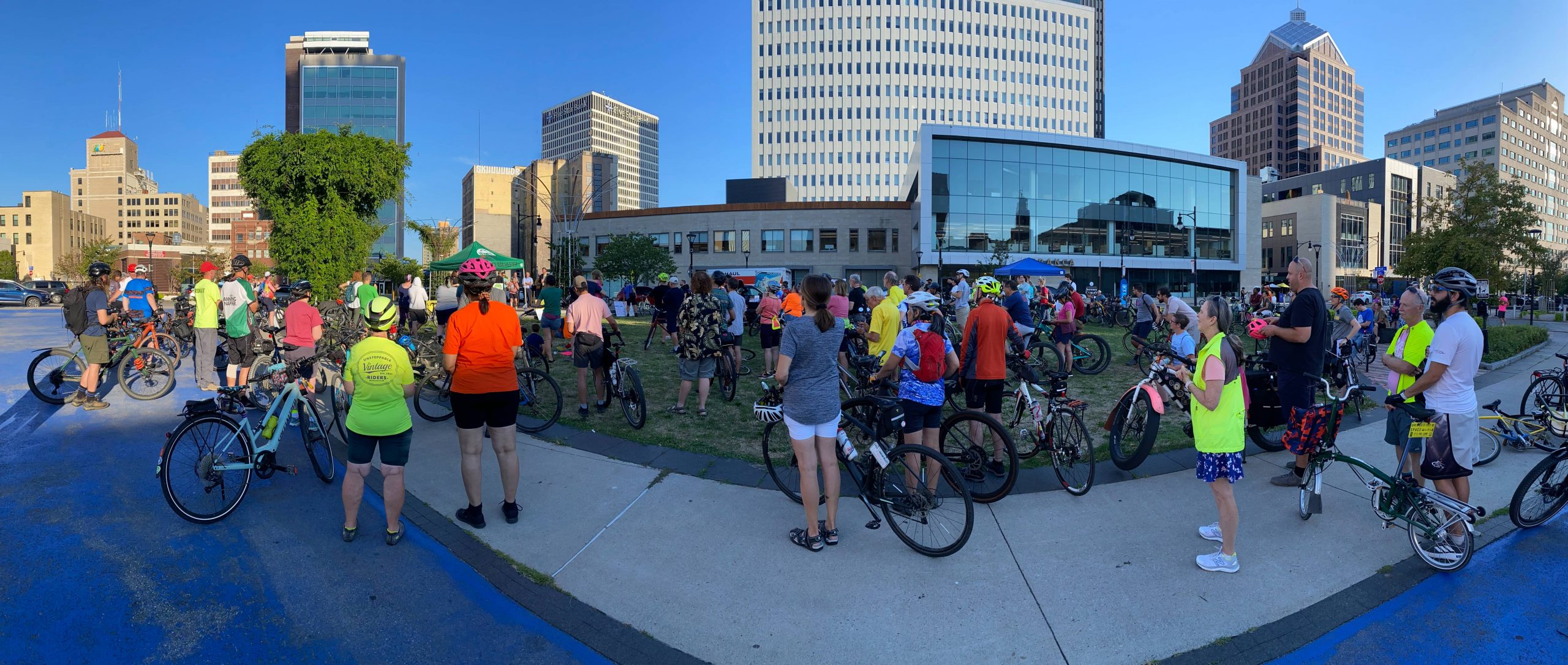
We are grateful for the 150 cyclists who attended 2024’s bike ride and rally at City Hall aimed at drawingmoreattention to the issue of the scattered and disconnected nature of bike investments so far and the need to change tacks, concentrating on attaining seamless and protected central axes of the envisioned Bike Spine Network in the near term.
This year, we have invited NYSDOT to tell us first-hand, “what is New York State doing to protect cyclists on state roads?” Despite the many Bike Resources we offer to encourage our community to ride, we can’t make up for the almost complete lack of dedicated, on-road bicycle infrastructure outside of the City of Rochester. According to the Federal Highway Administration, for about 60% of people who might otherwise ride their bike, these conditions discourage them from even trying to bike to work, to school or to the grocery store. This is especially true for women, children and the elderly.
WHAT DO WE WANT NEW YORK STATE TO DO?
Adopt a “complete streets” design policy for state roads and build infrastructure during regular maintenance projects. Implement dedicated bike facilities, sidewalks, enhanced pedestrian crossings, traffic calming or road diets (where appropriate) to create safer places for ALL users of the road.
Build safe cycling infrastructure on Empire Boulevard (Penfield) and Monroe Avenue and West Henrietta Road (Brighton) during upcoming road projects!
Build a safer, multimodal Lake Avenue as part of ROC Vision Zero!
Create a fully connected network of bicycle and pedestrian infrastructure in Monroe County working with towns, villages, the City of Rochester, Monroe County and residents. Improve connectivity across municipal boundaries, between neighborhoods, commercial centers, and transit hubs.
Allocate more funding to active transportation enhancements on all road projects.
*Please note that you can opt out of the Zeffy fee at the payment summary by marking other for the extra fee and listing a $0 contribution. Let us know if anything is confusing and we’ll get right back to you!
The Ride
“I loved street riding in a way that felt safe. It was so fun to experience our gorgeous city from that vantage.”
“Riding a type of ride I never do. It was very eye-opening to see all the cycling infrastructure in the city. I had no clue.”
Meet us at Rohrbach Brewing Company’s Beer Hallon Railroad Street, where this year’s ROC ‘n Roll will begin and end. The ride is rain or shine and the after party will be inside.
The 8-mile ride is a family-friendly, casual route that features the traffic-free Riverway Trail. Check-in starts at 10:00 AM. Kickstands up at 10:30 AM.
The 30-mile ride is a mix of bike paths, bike lanes, and bike boulevards — and will probably take you places you’ve never seen in Rochester on a bike! Check-in starts at 8:30 AM. Kickstands up at 9:00 AM.
Registration
$50 – Pre-registration
$60 – Day of registration (on 5/31)
Kids under 18 only $25
Includes after party admission (1 plate of food + your first drink/beer).
Snacks and water provided for riders pre- and post-ride, plus long route rest stop(s).
There are many incredible bike rides for a multitude of worthy and important causes every year, but the ROC ‘n Roll is the only benefit ride that directly supports bike advocacy and safe cycling infrastructure along with all the work we do to champion mobility in Monroe County.
If you can’t join the ride, feel free to donate to support the cause or attend the after party for riders and non-riders alike! Here are just some efforts your dollars would go to support :
NEW THIS YEAR! We’re excited to introduce a Teams option that will allow you to recruit and ride with your colleagues, friends and family! As a team lead, you can also encourage those who can’t join the ride, to support our cause with a donation in lieu of coming.
Once you register as an individual, you’ll have an option to create a team or join a team. Let us know if anything is confusing and we’ll get right back to you!
After Party!
Join us at ROC ‘n Roll event headquarters afterwards to eat, drink, and hang out! Enjoy live music from The Sideburns, and check out our raffle. Admission to the after party is included in rider registration. Non-riders can grab a ticket for just the after party via the registration button below. All are welcome!
Can’t make this event, but still want to support the cause?
We’ll gratefully accept a donation to let us know you’ll be with us in spirit! Visit our donation page to support our work.
Seeking Sponsors & Raffle Donations
Are you a business or organization interested in supporting our event? By partnering with Reconnect Rochester, you’ll join the movement for mobility equity, accessible recreation, sustainability, and safe streets. View sponsorship opportunities ranging from $500 – $10,000.
We also welcome in-kind donations for our RAFFLE. Bonus points if it’s Rochester or bike-themed! Contact kristin@ReconnectRochester.org if you’d like to make an item donation.
Guest blog by Nate August (Data Scientist & Graduate, University of Rochester) and Doug Kelley (Associate Professor of Mechanical Engineering, University of Rochester)
The year 2022 could be a watershed for active transportation in the Rochester region. The City of Rochester is writing a new Active Transportation Plan to update and extend its existing Bicycle Master Plan (completed in 2011). Meanwhile, Monroe County is writing its first-ever Countywide Active Transportation Plan. Both documents will lay out a vision and set priorities to guide transportation policy for years or decades. Their recommendations will literally be made concrete in communities’ sidewalks, bike paths, bus stops, and roads. Smart planning can improve equity and sustainability in everybody’s transportation – and can be empowered by data-driven insights.
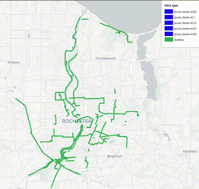
This spring, our team of graduate students and faculty at the University of Rochester’s Goergen Institute for Data Science, in partnership with the City of Rochester, set out to make data-driven recommendations for one key enabler of active transportation, the City’s bike infrastructure. We drew on a recent scientific study of bike networks in 62 other cities around the world, coauthored by researchers at the University of Rochester and the IT University of Copenhagen. We selected 86 points of interest around the City and calculated many thousands of routes among them, each along existing bikeways and streets, then located the street segments that currently lack bike infrastructure but frequently are part of the calculated routes. Those are places where new infrastructure would carry the most bike traffic and could most quickly improve users’ experiences of Rochester’s bike network. Here are the ten segments most important for bike transportation in Rochester, according to our analysis:
Monroe Avenue between Culver Road and Howell Street
Elmwood Avenue between Mount Hope Avenue and S. Goodman Street
Driving Park Avenue between La Grange Avenue and Saint Paul Street
Joseph Avenue between Cumberland Avenue and Norton Street
A connection between North Street and Central Park, either Davis and Scio Streets or Portland Avenue
State Street between Andrews Street and Smith Street
Smith Street between Lake Avenue and Saint Paul Street
South Clinton Avenue between Gregory Street and East Broad Street
Stone Street between East Broad Street and East Main Street
Saint Paul Street between East Main Street and Andrews Street
Our data-driven recommendations agree well with intuition and ongoing community conversation. Many of these street segments are also among the ten most obvious gaps in Rochester’s bike network, according to Reconnect Rochester’s Mind the Gap campaign. Many were recommended for upgraded bike infrastructure in the Rochester 2034 blueprint for growth and development, adopted by City Council in 2019. When different people using different methods tackle the same problem and find similar solutions, it’s a good sign that those could be the right solutions for the community – great minds think alike!
To learn more about the results and analysis that led to our recommendations, check out the interactive map below. It shows the data-driven recommendations along with existing bike infrastructure and the points of interest. You can pan, zoom, and toggle the layers. Altogether, these new segments span just eight miles (13 km) – short enough to be built rapidly and at low cost. As the map shows, they would link disjointed parts of Rochester’s existing bike network and connect it to more neighborhoods, bringing transportation equity to more residents.
Once these ten key segments have bike-friendly infrastructure, further construction would bring further improvements, and we used the same sort of analysis to ask what should come next. The animation below shows what the Rochester bike network could look like as infrastructure is added in 12-mile increments up to 60 miles. According to our analysis, communities are best served by prioritizing dense connections in the City center along with selected arterial connections to outlying areas.
There’s more good news when we rate the impacts of these recommendations in terms of directness. If you’re biking from, say, the Public Market to the downtown library, the directness of your route is the ratio of the actual distance you pedal to the distance as the crow flies. A more direct route is quicker and more efficient. By averaging over all the routes among all the points of interest, the directness of a whole bike network can be calculated. The scientific study found, surprisingly, that building new infrastructure during the early part of a bike network’s development can actually make directness worse because new neighborhoods are at first connected only by tortuous routes. But the good news for Rochester is that our strong foundation of roughly 75 miles of existing protected bikeways, bike boulevards and bike paths allows us to achieve steadily increasing directness. Here, bike routes will tend to get straighter and more direct with each new infrastructure project, as long as projects are chosen sensibly.
Our analysis is all about connecting points of interest, so the results depend strongly on how those points are chosen. We started with the City of Rochester Commercial Corridor Business Data, published as part of the 2034 Plan, which tabulates 1800 locations. By looking for clusters of nearby places, we reduced that long list to 86 points of interest, which constitute parks, museums, convenience stores, schools, and other businesses. We checked to be sure that the points didn’t unfairly favor any of the City’s four quadrants or areas with higher median income. In fact, we repeated our analysis with different points of interest, chosen with a preference for serving underprivileged neighborhoods and combined the results for our final recommendations. We’ve worked hard to make recommendations that promote equity and serve all residents.
You can also dig deeper into our analysis by reading the full report or adapt our tools and methods to other communities by downloading our analysis code. A similar study of Monroe County would be invaluable and would be easier now that we’ve added much of Rochester’s bike infrastructure to OpenStreetMap.
With more data and analytical processing power available now than humankind has ever before known, our society is in a position to devise and execute truly excellent plans for active transportation networks. Let’s make the most of the opportunity.
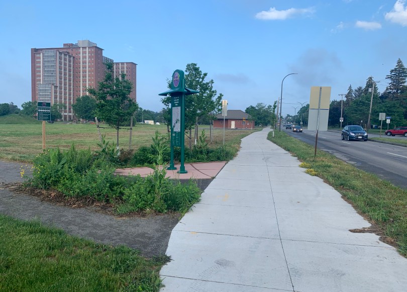
Over a year ago, I was excited by the opening of the long-awaited Highland Crossing Trail, providing a mile-long connective path that is now a section of my daily bike commute. The path is just a part of a decade-long planning effort to create a pedestrian and bike trail that connects the Empire State Trail (formally the Erie Canalway Trail) with the Genesee Riverway Trail via the Olmstead-designed Highland Park. And while I am thrilled with the collaborative effort between Rochester and the first-ring suburb of Brighton, there is a significant piece of this trail that isn’t the traditional definition of a trail at all.
The “double-wide” sidewalk along Elmwood Avenue is part of The Highland Crossing Trail (shown here two years ago under construction).
Enter the “double-wide” sidewalk, which, for an urbanist, is like dreaming of a Trek bike and getting a Huffy instead. You didn’t get what you wanted, but at least you got something. And hey, I’m not hating on the upgrade… I’m a firm believer in acknowledging every victory, no matter how small. Just because we don’t get what we ultimately wanted out of the gate doesn’t mean we, as advocates, aren’t making progress.
The double-wide sidewalk can, theoretically, safely and comfortably accommodate pedestrians and cyclists, and can be a useful and inviting step in welcoming more people on foot and on two wheels. The problem, of course, lies in the “left-hook” scenario, when drivers turning left into this “path” are hyper-focused on sneaking through two lanes of oncoming car traffic, ignoring the possibility that a pedestrian or cyclist who has the right of way may be approaching crosswalk. This is even more of a hazard for cyclists who travel at a higher speed than pedestrians, creating an issue of sightlines for the driver turning into the path. But this issue can be safely mitigated with a few practical steps.
Controlled Left Hand Turn Signal
For cars turning left into the mixed-use path, a left-hand turn arrow is essential in protecting cyclists and pedestrians using the crosswalk. A red arrow ensures that, when path-goers have the signaled right of way, drivers cannot turn into them.
Think about when you are behind the wheel, turning left across two lanes of oncoming traffic. Your focus is on the cars coming at you as you measure that gap in the traffic, seeing when you can step on the gas and make your left. On a busy road at rush hour, you might only have a momentary break in traffic… you have to take advantage! But how often do you look beyond the two lanes of traffic to see if there is a pedestrian or bike entering the crosswalk? Think about it… anyone entering the crosswalk at this point has the right of way, just like car traffic traveling straight through the green light. You, as a left-hand turner, must yield to sidewalk users as well when you make your left turn.
A red arrow controls left turns for cars when pedestrians have the right of way, restricting the potential for conflict when the car turns into the double-wide sidewalk.
Sidewalk Signals Change With Traffic, Not A Push Button
This is a big one for me. In major metros and downtowns, pedestrian crosswalk signals change with the traffic lights, removing the “please sir can I have some more” ridiculousness of the “beg button” scenario where pedestrians have to physically ask permission to legally receive a signal to cross a road. When implementing a double-wide mixed sidewalk, pedestrian/cycling signals should ALWAYS change with the traffic light. If a car is traveling northbound and has a green light, but a pedestrian traveling northbound has to push a button for the pedestrian signal to say she can cross, you’re doing it wrong. EVERY pedestrian crosswalk in today’s society should change regardless of whether someone pushes that stupid red button or not.
In all seriousness, the whole point of turning a sidewalk into a mixed-use trail is to create greater clarity around the prioritization of the pedestrian and the cyclist. And the scooter rider, and skateboarder, etc. Our pedestrian/wheeled trail user should be able to indulge in this prioritization without pushing a beg button.
If All Else Fails, Do The “Look Back”
As a pedestrian, bike and micro-mobility advocate, I don’t get in the habit of telling people to protect themselves against cars. Instead I bring to light the over-prioritization of the automobile and the need for drivers to share the road and show respect for those who aren’t protected by two tons of steel. That being said, in the case of the double-wide sidewalk, I would encourage users to “look back” to see if a driver is about to turn into you before and during your journey through the crosswalk. As much as I hate that we have to do so, a simple glance to see if a car might be left-hooking into our path as we cross a driveway or roadway is a small and essential step, ensuring our safety. While we must continue to place the onus on drivers to be more aware, and on designers to create safer streets, we must concede that this will take time. In the meantime, let’s be sure to take this simple step so that we can protect ourselves.
Double wide sidewalks can be a valuable “meet half way” step in connecting a robust trail network. But the purpose of a connective trail is to provide those of us on two feet and two (or more) wheels a safe, welcoming and enjoyable experience… most of all, one in which cars don’t pose a threat. Simply widening a sidewalk does little to achieve these goals. We must adapt traffic patterns and signaling if these efforts are to truly be considered a viable “improvement.”
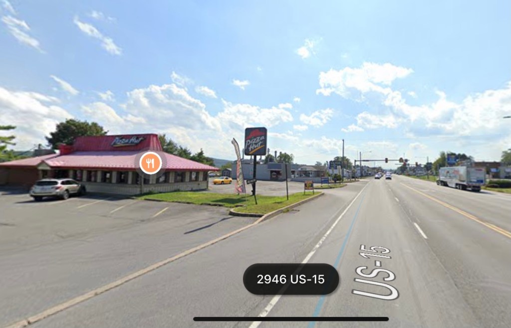
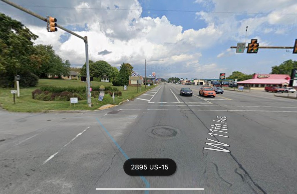
Last weekend my wife and I enjoyed a quick overnight trip to one of our favorite cities, Philadelphia, PA. In an effort to avoid toll roads, we took Route 15 for much of the way through the Keystone State, marveling at the beautiful rolling hills while skirting the Susquehanna River.
But in many places along the way, Route 15 transitions into Big Box Store Islands. One such place is in Shamokin Dam, home to massive parking lots servicing Best Buys and AutoZones, featuring every restaurant chain from McDonalds and Burger King to Pizza Hut, Chipotle, Denny’s, Red Robin, Applebee’s and more. What caught my eye on this particular journey through the minimum-wage wasteland was the total lack of sidewalks.
Let’s unpack this for a moment. We have a sea of low paying retail jobs that literally cannot be reached on foot or by bike. If you can’t afford a car, you don’t get a job here and you don’t get to shop here, plain and simple.
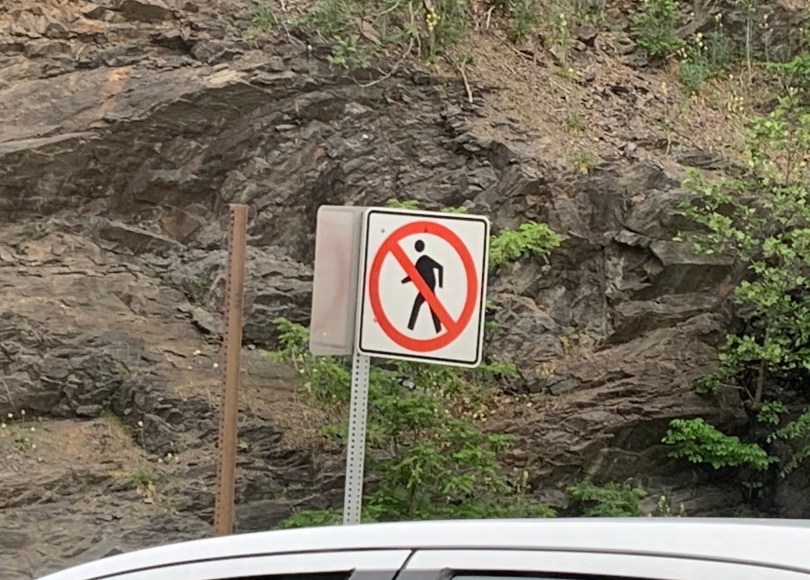
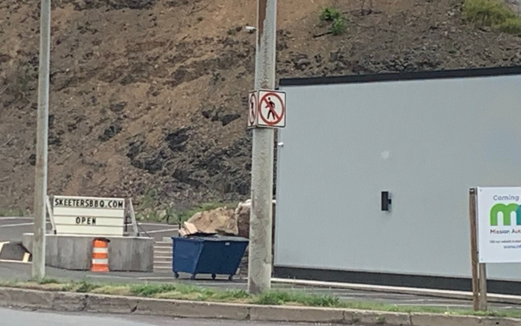
Furthermore, and this is my favorite… not only do they not have sidewalks, the local signage actually forbids pedestrians!
And beyond that, I tried to see if there might be a public transit option so that residents of nearby Selinsgrove, for example, might be able to access this area without owning a car. Spoiler alert, there is no public transit option.
A similar collection of big box retailers and chain restaurants exists south of Rochester, New York in the suburb of Henrietta. And while the land use and development strategies in this area are hideously car-centric and exclusive, at least it has sidewalks on both sides of the road and regular transit access.
Jefferson Road, Henrietta, NY
Shamokin Dam, on the other hand, is an island of minimum wage jobs that is only accessible by the most expensive form of transportation. Pennsylvania’s citizens living in this area must own a car and all the incredible costs that come with it in order to access these retail opportunities, either as an employee or as a customer. This is a perfect example of how flawed and shortsighted our U.S. development patterns and land use constructs truly are.
I’m pleasantly surprised with the amount of trail creation that is occurring across the United States. Urban paths, trails from former railroad beds, and neighborhood connectors… people are hungrier than ever to explore a new pedestrian or cycling experience. And for those like me, the ever-growing network of trails that can potentially remove us from the dangers of automobile encounters is so incredibly vital.
But as always, I’m going to challenge our townships, counties and cities to think bigger. I’m not spitting in the face of real progress, I’m asking everyone, especially in our denser communities, to consider two standards with regard to trail creation, use and maintenance going forward.
Pave Your Trails
I am so proud of my home city of Rochester and the surrounding towns for making trail creation a priority. There are so many new trails that have popped up in our area, and it’s truly a testament to a handful of amazing people with great vision for healthy recreational use and sustainable transportation. But most of these new trails are unpaved “cinder paths.” While cheaper to construct, they are far less convenient for thin-tire bikes such as road bikes and fix-geared bikes. Furthermore, the new rage of electric micro-mobility (e-scooters, e-skateboards, etc.) has the potential to change the way we move about our communities. But most of these vehicles have small, hard, unforgiving wheels that perform poorly on unpaved surfaces.
For many who are reading this, the response to the sentence above may very well be “GOOD!” The pushback against electric micro-mobility is substantial. But my take is that anything that gets Americans out of their cars is positive. If you want to retain young people in your community, allow for the recreational and practical proliferation of electric micro-mobility. Build for a community that welcomes as many forms of transportation as possible. Only then will a mobility-progressive future be possible.
Plow Your Trails
This is a message specifically directed at northern states that receive significant snowfall. Creating trails that are unusable for 4-5 months during a year is, frankly, a denial of the potential for trails to be year-round public resources for transportation and community health.
Paved trails can be plowed easily, providing local residents a year-round outlet for exercise and safe mobility. In the Greater Rochester New York area, the Empire State Trail (Erie Canalway Trail) is partially paved, but goes unplowed during the harsh winters that can see upwards of 100 inches of snow. The brand new Highland Crossing Trail, which I happily take every day to get to work, is unpaved and unplowed, forcing me onto the busy streets on my bike during the winter months. Again, I appreciate my local governments for being proactive in creating a community resource. I do, however, blame a century of one-dimensional transportation prioritization in the United States that has created the belief that the only way to practically access jobs and resources in our community is via the automobile, the most exclusive, unsustainable and individualistic form of transportation available.
If we truly acknowledged the importance of inclusive mobility, we would readily pave and plow all of our trails, new and old. But as of now, we as a culture would rather see trail creation as a seasonal recreational nicety instead of a legitimate year-round alternative transportation solution. This must change with regard to the future of mobility in our country.
Get the confidence and skills you need to bike around our community by taking a Smart Cycling class!
Many people like the idea of biking more, but they don’t feel safe mixing it up with cars. In this class, students will learn the rules of the road and proper roadway position. We’ll examine safe cycling techniques and ways to make cycling easier and more enjoyable. The class will incorporate classroom learning, parking lot maneuvering drills and a short group ride navigating different traffic scenarios.
MEETING POINT: Reconnect Rochester’s office downtown: 400 Andrews Street, Suite 100, Rochester, NY 14604
COST: $10 (If payment is an impediment, folks can register for free by emailing Jesse jesse@reconnectrochester.org)
IMPORTANT NOTES:
Children under 16 are required to take the class with a parent or legal guardian.
These classes are for folks who already know how to balance and ride a bike. For more information on private learn-to-ride classes, contact cycling@ReconnectRochester.org.
Participants must come with their own bike.
Participants must wear a helmet.
The class will go on rain or shine. In the event of rain, the classroom portion will be extended to cover more Smart Cycling curriculum.
For Rochester Street Films this year we asked local filmmakers and ordinary citizens to share their perspective on what it’s like to get around Rochester without a car. No rules; No restrictions; No filter.
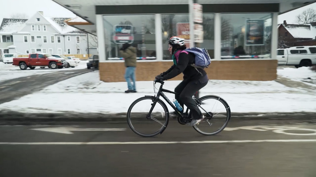
Rochester NY in February. It’s 19ºF and the ground is slick with snow and ice. But Mona Seghatoleslami, host of WXXI Classical 91.5 FM will brave the cold attempting to ride her bike from her home in Brighton to her job in downtown Rochester (about 4 miles). Afterwards, Mona heads to Tryon Bike shop to find out what type of gear she’ll need for serious winter cycling…
We’d like to ask for your help getting these films in front of as many people as we can. If you would like to host a mini screening of Rochester Street Films in your neighborhood, please contact us.

")
")

")