In this final installment of our Complete Streets Blog Series, guest author David Riley will highlight a sampling of intersections and trouble spots that were nominated for the Complete Streets Makeover project, and share his ideas for how they might be made safer for cyclists and pedestrians.
David Riley is a planner, a researcher and a former local journalist. He lives in Rochester with his wife and daughter.
Safer Rochester Streets, An Intersection at a Time
By David Riley
Parsells Avenue and Greeley Street used to be a wide, asphalt-gray intersection like many others.
In September, Reconnect Rochester’s first-ever Complete Streets Makeover program transformed it into a vibrant focal point of the Beechwood neighborhood. Temporary curb extensions and bollards tightened the intersection’s sweeping corners, and a dazzling mural brightened the pavement.
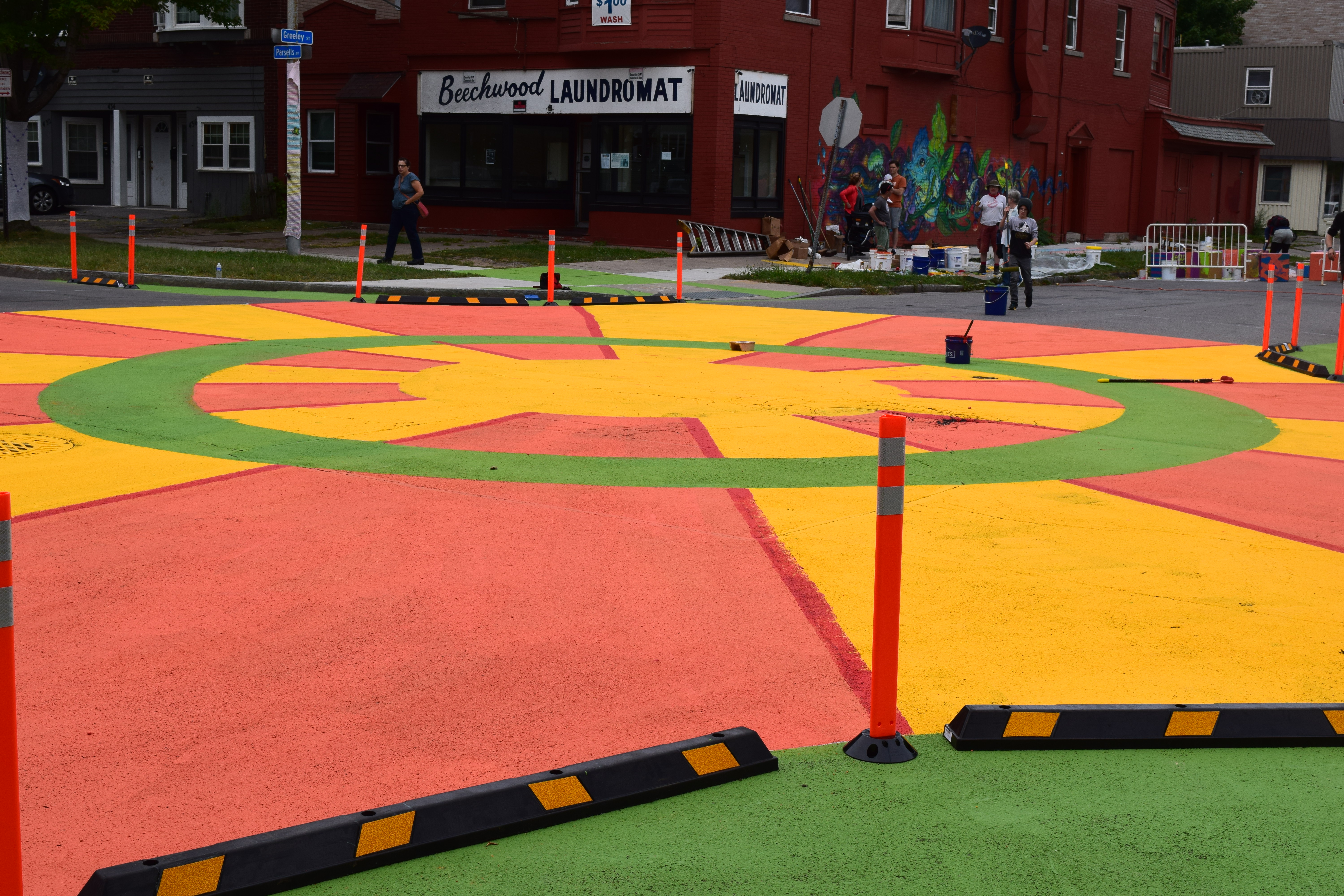
The changes sent two messages: This place matters to the neighborhood, and it’s a place that prioritizes safety over speed for drivers.
This intersection was one of many the public nominated for the Makeover program. Reconnect sought to redesign a local trouble spot to make it safer and more welcoming to pedestrians, cyclists, bus riders, people who use mobility devices like wheelchairs or walkers – and ultimately, drivers, too.
Overall, Reconnect received more than 90 submissions describing stretches of road that also might be good candidates for a makeover – or in some cases, radical reconstructive surgery.
Parsells and Greeley was a worthy spot to start, and Reconnect and its partners only have capacity to work on one intersection at a time. But it’s well worth exploring the other nominations.
These submissions paint a broader picture of challenges with navigating Rochester-area streets. They also provide an opportunity to delve deeper into the menu of options available to make our roads more “Complete” – to explore how we might design them if, by some lucky chance, we had a limitless supply of paint, bollards, curb extensions and other tricks of the Complete Streets trade.
Familiar Problems
Many of these difficult streets have some of the same problems in common. Like Parsells, a number of intersections nominated were quite wide or have sloping corners that encourage motorists to speed through turns even as pedestrians try to cross. Some streets are oversized for the traffic they handle, another way of encouraging high speeds at the expense of anyone not in a car. Others lack stop signs, speed bumps or other features that might mitigate traffic speeds or encourage drivers to watch out for pedestrians or cyclists.
Some also lack basic amenities like crosswalks or bicycle lanes, despite major destinations like schools. In some places, drivers treat existing bike lanes like a passing lane or a parking lane. Some streets intersect at bizarre angles or in configurations that might confuse anyone, however they’re traveling. And some locations combine more than one of these factors into an especially harrowing experience.
In short, many of our region’s streets are designed in ways that detract from neighborhood safety, stability and vitality.
Uncomplicated Solutions
Like Parsells and Greeley, many of the potential solutions are relatively cheap – paint, movable curb extensions, bollards – at least to begin with.
Here, we’ll discuss some concepts for improving the trouble spots nominated for makeovers. These ideas are purely that – conceptual – and are meant to generate discussion, not to prescribe specific solutions. Neither I nor most of the people who submitted nominations are transportation planners or traffic engineers, and we haven’t studied these places in detail. You might have better ideas about how to solve these problems, and we hope you’ll share them.
Some of us do have familiarity with Complete Streets principles, planning and urban design. These are basic ideas meant to start a conversation about how, like the intersection in Beechwood, some effort and minimal investment could make greater Rochester a little safer and more hospitable.
With that disclaimer out of the way, here are four trouble spots for your consideration.
South Goodman Street, South Clinton Avenue & Henrietta Street
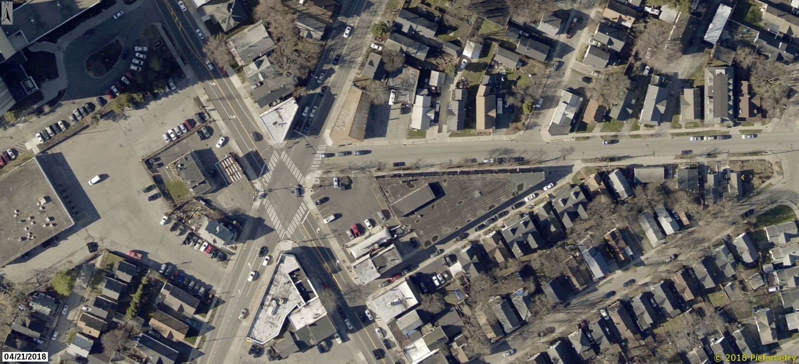 This intersection could be a thriving connection point between the South Wedge and Swillburg, two southeast Rochester neighborhoods that are otherwise walkable and cyclist-friendly.
Instead, it’s a sea of pavement with faded crosswalks, no bicycle lanes and a confusing street pattern. South Goodman and South Clinton meet in an X configuration, with Henrietta feeding into Goodman from the east. To get a sense of the sheer size of this intersection, it’s more than 120 feet between the northern and southern angles of the X, or about one-third the length of a football field, according to Google Maps.
Reconnect Rochester received several submissions for this spot, with contributors noting blind spots around corners, intimidating conditions for cyclists, complications caused by delivery trucks blocking lanes outside restaurants and bars, and drivers who exit I-490 and drive down Goodman as if they’re still on the highway. The landmarks here – the Highland Park Diner, the Cinema Theater, the Angry Goat – seem to succeed despite the intersection rather than because of it.
Possible solutions: in the absence of granite and concrete, this seems like a case for solutions that mostly could be accomplished with paint, bollards and curb extensions. Each street’s approach to the intersection could be tightened and the curbs at the points of each corner extended slightly to create sharper turns and slow vehicle speeds.
This might also be a case for a diagonal crossing, allowing people to cross the intersection east-west from the southwest corner of Goodman to the southeast corner of Clinton, or the narrowest point in the intersection. (I’m not sure you’d want a full-fledged pedestrian scramble, which allows people to cross diagonally in any direction, because the distance between the northern and southern points of the intersection is so wide.) This configuration would require traffic signals to stop cars in all directions when people cross the intersection, which typically improves pedestrian safety. Designing the crosswalks colorfully would help to make this drab intersection better reflect the surrounding neighborhood.
South Goodman, at the very least, could use separated or protected bicycle lanes. The City of Rochester’s Bicycle Master Plan, completed back in 2011, identified the length of Goodman from East Main Street to this intersection as a Tier I priority to be restriped for bicycle lanes. It’s also the heavier traveled of the two streets, according to traffic counts from the state DOT, and has a nearby interchange with I-490 where cyclists also told Reconnect they often feel unsafe. Goodman south of this intersection and South Clinton were both Tier II priorities.
Allowing only right turns from Henrietta Street onto South Goodman Street could also help to simplify the intersection and eliminate one source of car traffic in an already confusing spot.
West Main Street
Rochester has made strides in reshaping portions of Main Street for the better, but largely on the east side of the Genesee River. There are now wider sidewalks along the downtown segments of the street, and a bicycle lane travels continuously east about a mile from downtown nearly to Goodman Street, which makes traversing the overpass above the Inner Loop less terrifying than it used to be.
The same can’t be said of West Main Street west of the I-490 underpass. The street is consistently four lanes wide until it meets Chili and West Avenues, without any bike lanes along this stretch, which is nearly a mile long. The aforementioned intersection is also a Y-shaped nightmare of unclear lane markings and limited options for pedestrians or people using mobility devices to cross safety except at the narrowest end of the “Y.”
Possible solutions: I hedged a bit about a road diet on the discussion of Lake above, but West Main seems like a perfect candidate for a reduction in car lanes. The street currently carries roughly half the average daily traffic volume that a two-lane street can handle, per the National Association of City Transportation Officials. It’s hard to understand the need for four lanes plus the occasional turning lane. Reducing it to two lanes with a center turning lane with bicycle lanes on both sides of the street could go a long way to making this a safer stretch with little, if any, inconvenience to motorists.
As for the intersection with Chili and West, I’d like to see a crosswalk on the eastern side of the intersection to allow pedestrians another opportunity to cross West Main. If we want another diagonal crosswalk, there may be a case to be made for adding one from the western tip of the intersection of West and Chili Avenues, near the West Avenue United Methodist Church, to the north side of West Main. Reducing the width of both Chili and West Avenues and adding curb bumpouts where West Main enters the intersection also could be helpful.
St. Paul & Bittner Streets / N. Clinton / Joseph Avenue at the Inner Loop

Navigating any of these major streets as they cross the northern portion of the Inner Loop can be pretty scary for a pedestrian or cyclist. Walking along North Clinton from the Downtown Transit center to the Amtrak station on Central Avenue feels a bit like strolling along a highway just above another highway as you cross the Inner Loop and Cumberland Street, with cars making quick turns off and on Cumberland. These crossings seem to share high vehicle speeds, sweeping corners and wide intersections. Bicycling north on St. Paul has the added bonus of narrowing from two car lanes to perhaps one and a half as the street travels under a rail bridge after the Inner Loop overpass.
Possible solutions: The City is considering a study of removing the remainder of the sunken Inner Loop expressway – similar to the project that filled in the Inner Loop East, except that this portion is longer and more heavily traveled. This is a vast oversimplification of what would surely be a very complex and costly project, but removing more of a highway that cuts directly through the city would be welcome.
Lacking the tens of millions of dollars that would require, I’d just settle for crosswalks in all directions and clearly marked bicycle lanes on all streets leading up to and through these intersections, particularly on the bridges above the Inner Loop.
Bay Street and Culver and Merchants Roads
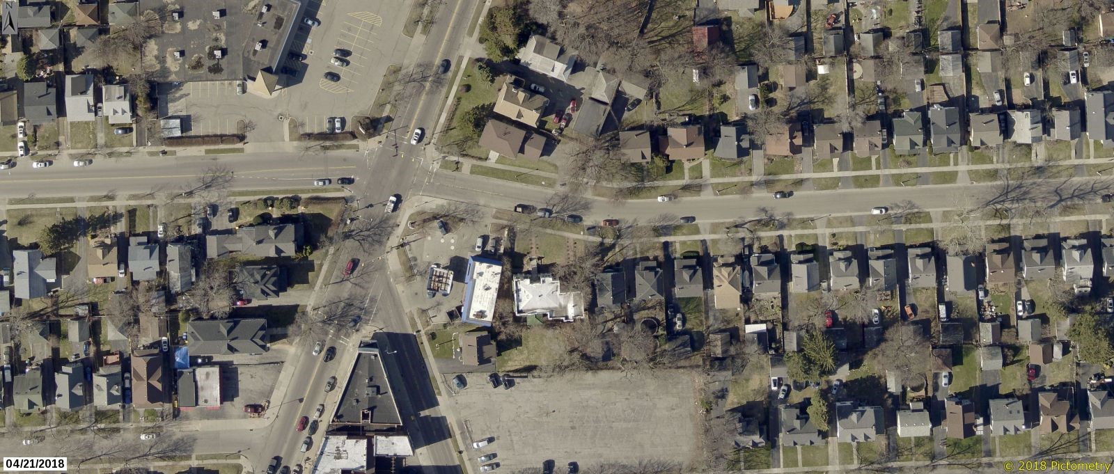
This intersection has the makings of a hub that connects several neighborhoods (Beechwood, the Triangle of North Winton Village, Homestead Heights, North East Main Neighbors United, the Laurelton neighborhood in Irondequoit). It’s got Merchants Grill, James Brown’s Place, L&M Lanes, the nearby Nino’s Pizzeria, Johnny’s Irish Pub, a Rite Aid and what seems like a prime redevelopment opportunity in the building at the corner of Merchants and Culver. Volunteers also have helped to install bicycle racks and street murals recently. There are stops for key bus routes surrounding the intersection.
The intersection of Bay Street, Culver Road and Culver Parkway would be a fairly straightforward four-way intersection if not for the Y-shaped merger of Culver and Merchants to the immediate south. It makes for a messy, confusing spot to navigate as a driver, pedestrian or cyclist. Unclear lane markings make left turns onto Merchants particularly muddy for vehicles or cyclists traveling south on Culver. Vehicles entering and existing a Sunoco gas station at the intersection adds another layer of unpredictability.
Possible solutions: This is another case where paint and curb extensions could do a lot of good.
Extending the curb and sidewalk at the southern tip of the intersection would help to define the intersection of Merchants Road with Culver, while also providing additional space for a potential business in the now-unoccupied retail space on the first floor of the corner building to put tables or merchandise outside. Curb bumpouts, particularly along Culver, also could better define the intersection and reduce crossing distances for pedestrians.
Bicycle lanes would be more than welcome on Culver, along with more clearly defined lanes for vehicles traveling along Culver through the intersection. I’d like to see a single travel lane and a short left-turn lane for turns onto Merchants for vehicles traveling south on Culver.
________
We hope you enjoyed our Complete Streets Blog Series!
We’re excited to announce that our awesome team of partners are on board to continue our Complete Streets Makeover program in 2019! So keep taking note of the intersections and trouble spots you experience in your daily travels that could use a re-design, and keep an eye out for our call for public submissions in late winter or early spring. Together, we’ll keep advocating to design our streets for people, and we’ll keep making it happen one intersection at a time.
Happy holidays from all of us at Reconnect Rochester!