No Comments

When Streets Were Equitable

Written by Arian Horbovetz and originally published on The Urban Phoenix blog.

“Dude, get out of the road,” you yell in an enraged state fueled by someone’s blatant disregard for the fact that you woke up late and are traveling 10mph over the speed limit only to encounter a man “jaywalking” across the road in front of you. Your displaced anger bubbles over as you find yourself inconvenienced for a whole 9 seconds.

We’ve all been there… getting behind a car that’s traveling 10mph under the speed limit, trying to pass a cyclist with no shoulder, or yelling at a pedestrian who crosses the road outside of a crosswalk with no regard for your time.

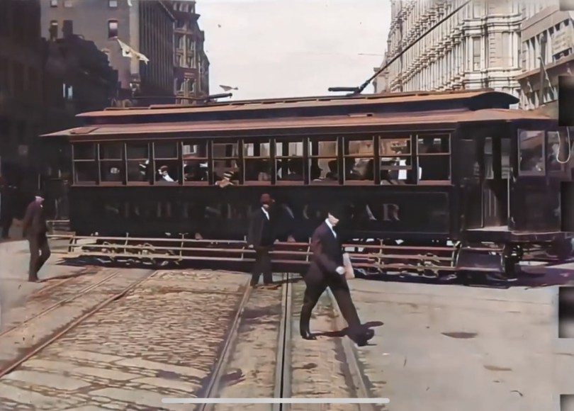
Let’s step back in time to 1906. Jaywalking, or the illegal crossing of a street in a non-designated crosswalk, was 20 years from being a thing. The automobile was just beginning to assert itself as a semi-regular addition to city streets that accommodated a multi-modal construct. Can’t imagine what this looks like? Let’s look at this amazing digitally remastered video of a 1906 San Francisco street car ride.

The most important thing to note in this video is how diverse the street traffic is. Horse and buggy, trolley, automobile, bicycle, pedestrian… they all move at approximately the same speed. The well-to-do owner of the car travels at a speed that is similar to the pedestrian and cyclist. While the driver may be able to enjoy an independent, stress-free commute, he or she is subject to the street congestion caused by many different forms of mobility. And while this low-speed chaos would likely be psychologically catastrophic to the car commuter today, it presents some incredibly meaningful lessons with regard to our streets and their effect on society.

Multiple Modes of Mobility

Trolleys, carriages, bikes, cars and pedestrians… count the number of different forms of mobility in this video. The streets were truly for everyone, regardless of speed, size or socioeconomic status.

Similar Speed

Equitable transportation is rooted in the idea that anyone can access jobs and resources equally, regardless of their socioeconomic status. In this piece of video, pedestrians, mass transit and cars move at a similar speed. The difference in velocity between the most exclusive form of transportation and the most humble form of transportation is negligible. Today, the average 15 minute commute by car is likely to be over an hour by bus. The prioritization of the automobile has completely eradicated equitable access to jobs and resources.

Density and Community

Slower, more equitable mobility leads to greater, more efficient urban density. Suburban sprawl has created an inequitable construct based on “pay-to-play” access of upwardly mobile resources. When multi-modal transportation is encouraged, more efficient and equitable communities are possible.

In the video above, the fastest form of transportation, the cars, are moving about 2-3 times the speed of pedestrians. Sure, that difference might be a great deal more on an open road, but the top speed of between 30 and 50 miles per hour for the average Ford… not to mention you needed oil every 250 miles, and the fact that highways were just a glimmer in the hopeful eye of an urban enemy. A humorous note, just two years earlier, a driver was given the first speeding ticket in Dayton Ohio for going 12mph in a 5mph zone.

At such low speeds, the prospect of “sprawl” was horribly impractical. As a result, cities remained unquestionable centers of equity, efficiency and productivity. Because cars were just a slightly faster mode of transportation in a sea of other mobility options, 15-20 mile car commutes were simply not possible.

But cars became faster. Car and oil companies became the dominant lobbyists in the United States. Highways were built to allow for greater sprawl, all subsidizing people’s desire to create exclusive communities outside their city centers.

In Conclusion

I shared this video with a number of friends. The comments back marveled at the clothing, the trolleys, the horses, the man sweeping horse droppings, and the maddening chaos of multi-modal traffic. But when I look at videos like this, I see what cities were like when mobility was far more equitable. Sure, our cities were dirty, crowded, smelly and sometimes scary. Sanitary amenities, cleaner energy and a host of other legal and environmental issues were still hurdles for cities 1906.

But the power of the city as the social, economic and equitable hub of humanity was far greater than it is in the U.S. today. Architecture hasn’t changed all that much, save the skyscraper. Street layout is pretty much the same. The big difference is the fact that the formally diverse streets featuring slow traffic have been replaced with exclusive automobile access, allowing those who own cars to speed to their destinations while those who must rely on public transit are subject to maddeningly underfunded networks, long wait times and inefficient commutes.

The video above shows what streets were meant to be. They were havens for diverse mobility instead of space that is solely dedicated to speed and exclusivity. Our cities have paid the price for this massive mistake, and as a result, equity and upward mobility continue to lag compared to much of the rest of the industrialized world.


3 Comments

Copenhagen transportation: A day in one family’s life

Guest blog by Doug Kelley.

A family in Copenhagen–mine.

Copenhagen is famous for having the world’s best bike infrastructure and highest rates of bike transportation. (OK Amsterdam, you’re not bad, either.) Transit nerds love to extol the engineering details, celebrate the signage, and explain the traffic patterns in excruciating detail. While I admit getting excited by those nerd-outs — I’m an engineering professor and a lifelong cyclist, after all — the real point is the beautiful lifestyle enabled when communities “Copenhagenize.” So here’s a snapshot, one typical day of the lifestyle, as lived by my family and me during our sabbatical year away from Rochester.

The bike lane on busy Lyngbyvej is wide and separated from motor traffic. At rush hour, all the lanes fill, but cycling is safe and pleasant anyway.

After a Danish breakfast of pastries, yogurt, and coffee, I hop on my bike for the morning commute. Neighborhood roads bring me to Lyngbyvej (pronounced “loong boo vye”), busy at rush hour with more car traffic than almost any road in central Copenhagen. Still, it’s a pleasant place to cycle, because its wide bike lanes are separated from the cars by curbs, and because automotive traffic is held to reasonable speeds by stoplight timing and posted limits. At rush hour, Copenhagen’s roads carry more bikes than cars, so I feel like part of the crowd. Some cyclists ride slower, and some ride faster, passing on the left, often after ringing their bells to avoid surprises. (Impatient commuters sometimes ring excessively.) As I head south, motorists turning right wait at the intersection for a gap in the long line of cyclists passing in their own lane.

From experience I know that the stoplight at Tagensvej (pronounced “tah gens vye”) is slow, so seeing its pedestrian signal turn green up ahead, I pedal harder. A green bike signal comes next, then a green signal for motorists. I sail through as the bike signal turns yellow. Arriving at work in under 10 minutes after a 1.5-mile ride, I’m invigorated and just starting to warm up. Bike parking is ample, with spots in the open by the nearby entrance, covered spots further away, and beyond them, an underground bike-only parking deck for bad weather and expensive bikes. Most folks ride commuter bikes, akin to what Americans might call hybrids, neither flashy nor expensive, just practical. I pull into a covered spot.

Cyclists and pedestrians in Copenhagen can be confident that their safe routes won’t dead-end, even when construction in booming Nordhavn gets in the way.

Meanwhile my younger daughter, age 12, sets out for school, also biking. She soon turns left from Lyngbyvej, using the usual jug-handle method: ride across the intersecting street, stop until the signals change, then ride left across Lyngbyvej and on toward school. That keeps her in the bike lanes all the time, so she doesn’t have to change lanes and cut across motor traffic. Like the Danes, she gives a hand signal beforehand. A few blocks later, road signs direct her through a slight detour. Construction is blocking the usual bike lane, so the motor-vehicle lanes have been narrowed to make room for bikes and pedestrians, protected by a steel barrier. Construction is no excuse to block important bike and pedestrian thoroughfares.

Copenahgen may have the world’s highest rates of bike transportation, but it doesn’t have the world’s best weather. Today it’s drizzling, so my daughter is wearing a shell jacket, boots, and her new waterproof pants. Danes like to say there is no bad weather, only bad clothing. Sure enough, rain hardly changes the number of cyclists on the road, and today the nearby cyclists wear clothing varying from Gore-Tex to full-body ponchos to soggy blue jeans. Most of their bikes have fenders, and lights are required by law–winter nights in Denmark are long.

My daughters turn left here on their way to school. Cars, bikes, and pedestrians all have separate lanes and separate traffic signals. Cyclists can lean on the railing above the curb, and the timer (circle of white lights) tells when their signal will change. Also: Danes dress well, regardless of whether they are pedaling!

Having stuff to carry doesn’t keep people from cycling, either. I take my laptop and lunch to work in waterproof saddle bags. My daughter carries a backpack, like many of the riders around her. Nearly all their bikes have racks on the back, often bearing loads held with bungee cords. Mail, football equipment, take-out, Ikea furniture, and all manner of things get carted around on sturdy flatbed cargo bikes, sometimes with electrical assistance to make pedaling easier. Danish parents commonly carry their kids to school in cargo bikes with boxed compartments on the front. Older kids sit on tag-along bikes attached to mom’s or dad’s. Most have learned to ride solo by age 3 or 4, and are getting to school on their own bikes by age 6 or 7.

My older daughter, age 13, isn’t a morning person and leaves later, finishing her 2.2-mile commute and parking her bike just in time for class. After school, the clouds persist but the rain has quit, so she decides to bike with classmates to Stroget, one of the largest pedestrian-only market streets in Europe, to window-shop and buy some candy to share. As her dinnertime curfew approaches, she considers the headwinds and decides not to bike all the way home, instead catching the S-train, which allows bikes anytime. Metro trains also allow bikes, though not at rush hour, and only with an extra ticket. But she might be tempted to take the Metro anyway once the new Orientkaj stop opens–it’s next-door to her school.

The nearby Vibenshus Runddel metro station, which my daughters and I pass on our morning commutes.

While the rest of us are away, my wife shops for some hygge (cozy) furnishings at the neighborhood secondhand shop, then picks up groceries for dinner, including fresh-baked bread. She could bike both places, but decides to walk for exercise, and anyway the grocery store is only three blocks from our apartment. After working at home awhile, she rides the S-train to Klampenborg to jog in the woods. In summer, she might instead bike to the Nordhavn harbor for a swim, or cycle 25 miles to Helsingør, then ride the train home. Neither she nor I need to plan our day around driving our kids from place to place, since they can capably bike and navigate public transportation on their own.

Home together at the end of the day, the four of us light candles, start a fire in the wood stove, and sit down to dinner. My younger daughter is ravenous after biking home from football (pronounced “soccer”) practice. My older daughter is proud that her new fitness tracker logged 14,000 steps since the morning. We have lived another day of our full and busy lives, traveling to work and school and many other places without driving a car or wishing for one. Our daily travels have required nearly no fossil fuel and put nearly no carbon into the atmosphere. Outdoor exercise lifts our moods and keeps us fit. Alternative transportation gives the kids freedom to move about independently, making extra time for us parents. And in the summertime, when the days are long and the skies are clear, Copenhagen transportation is even more lovely.

Stroget, the pedestrian street where my older daughter goes with her friends. Cargo bikes like the one parked here can carry a couple of small kids or a lot of groceries.

Crucially, you don’t have to live in Copenhagen to enjoy this lifestyle. Ride RTS. Rent a Pace bike. Stroll to your neighborhood cafe. Bike to work and to the Public Market. Though Rochester’s bike infrastructure doesn’t match Copenhagen — nobody’s does — you can bike to many destinations without using big, ugly roads clogged with motorists. Pedal on the Canal Path, on the River Trail, on the cycle tracks along Union Street or Elmwood Avenue, on the network of Bike Boulevards, or simply on quiet streets that parallel the big thoroughfares. Teach your kids to bike, show them safe and effective routes, let them walk, and teach them to use public transportation. Tell community leaders about the importance of building alternative transportation infrastructure. And support organizations like Reconnect Rochester that are enlarging this lifestyle in Rochester. 

No Comments

The Power of the Sneckdown

Story By Arian Horbovetz.  Arian is a Rochester resident and creator of The Urban Phoenix, a blog that discusses urban and community design and topics as our cities transition to a better future.

As I write this, the city of Rochester is passively preparing for yet another battle with a dreaded but familiar foe, lake effect snow.  Winter boots and labored commutes will surely be the icebreaker (pun intended) conversation starters at the office water cooler today. But for the Urban Planner, as well as the casual observer, periods of light snow can be opportunities for great discovery.

In that time when the first whispers of a snow storm cover our streets and the plows are still dormant in their stalls, we navigate our vehicles on roadways by following the tracks left behind by the cars that recently came before us.  To an Urban Planner, these tracks, especially with regard to their path through intersections, are of particular importance.

The ability to see the space that cars use (or rather don’t use) when traveling through an intersection by looking at these tracks through the snow gives us a golden opportunity to demonstrate how and where our streets can be narrowed.  Think of it like an Urban Planner’s forensic blacklight, revealing the key unseen evidence of superfluous roadway.

These visual clues created by snow and tire tracks through our intersections are called Sneckdowns.  While the name might conjure the image of a Dr. Seuss character, it is actually derived from the combination of “snow” and “neckdown,” which is a term for sidewalk additives and extensions that reduce traffic speeds and increase pedestrian access.

Photo of Philadelphia Sneckdown

Photo courtesy of Jon Geeting

Photo of Philadelphia Sneckdown

Photo courtesy of Jon Geeting

In 2014, urbanist Jon Geeting authored a Slate article in which he took simple photos of sneckdowns on Philadelphia streets.  His efforts inspired walkability advocates around the world to do the same, but best of all, it led to real change in his own backyard.  

Before Picture. Photo courtesy of Jon Geeting

Jon Geeting’s Sneckdown photo of this intersection paved the way for this concrete island which acts as a traffic calming measure and a pedestrian island for safer crossing. Photo courtesy of Jon Geeting

Clarence Eckerson’s famous STREETFILMS video shows some incredible examples of how overbuilt our streets really are.  With a measuring device and some cold weather grit, Eckerson puts the power of sneckdowns right in front of the viewer, showing how snowbanks that accumulate on city streets can give us a clearer understanding of how to construct and reconstruct our streets going forward.

Why all this fuss about narrowing streets and slowing traffic?  Because decreasing automobile speeds by narrowing lanes and intersections, as well as prioritizing pedestrians, lead to safer, healthier communities.  Furthermore, promoting walkability and pedestrian comfort has been shown to feed economic growth and stability.  

Sneckdowns also give the average citizen the ability to see where change can be enacted.  It doesn’t take a traffic engineer to spot tracks in the snow, it takes a conscious observer who is genuinely concerned about safety and walkability in their environments.  

Hey Rochester!  Next time it snows, take to the streets and see if you can spot overbuilt space on our roads and intersections.  It can be a fun, interesting and positive way to start the conversation about safer streets in your neighborhood, and may even lead to the change we want to see!

No Comments

Complete Streets Series (Part 3 of 3): Safer Rochester Streets, An Intersection at a Time

In this final installment of our Complete Streets Blog Series, guest author David Riley will highlight a sampling of intersections and trouble spots that were nominated for the Complete Streets Makeover project, and share his ideas for how they might be made safer for cyclists and pedestrians.

Read more

No Comments

Complete Streets Series (Part 2 of 3): Re-Designing Our “Finalist” Streets for People


Back in May, we launched our Complete Streets Makeover project by asking the general public to help identify the intersections and trouble-spots where you live, work and play that could be redesigned to make them safer for everyone. We received over 90 nominations, and after a careful process to examine each and every submission, we selected the following locations:

Read more

No Comments

Complete Streets Series (Part 1 of 3): A Neighborhood Intersection Transformed

In the U.S., pedestrian fatalities have skyrocketed, increasing by 46% from 2009-2016. According to our Crash Map, over 4,000 crashes in Monroe County from 2010-2017 involved bicyclists and pedestrians. Eight people die on our streets every year as a result of these crashes.

Read more