3 Comments

How should we grow Rochester’s bike infrastructure? Let’s ask the data.

Guest blog by Nate August (Data Scientist & Graduate, University of Rochester) and Doug Kelley (Associate Professor of Mechanical Engineering, University of Rochester)

The year 2022 could be a watershed for active transportation in the Rochester region. The City of Rochester is writing a new Active Transportation Plan to update and extend its existing Bicycle Master Plan (completed in 2011). Meanwhile, Monroe County is writing its first-ever Countywide Active Transportation Plan. Both documents will lay out a vision and set priorities to guide transportation policy for years or decades. Their recommendations will literally be made concrete in communities’ sidewalks, bike paths, bus stops, and roads. Smart planning can improve equity and sustainability in everybody’s transportation – and can be empowered by data-driven insights.

Sharrows in Rochester

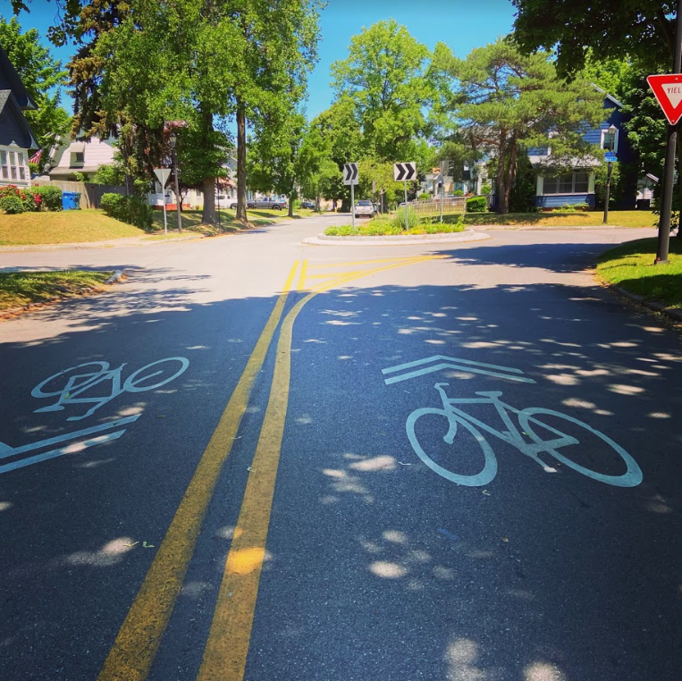
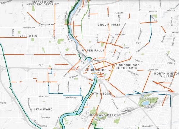
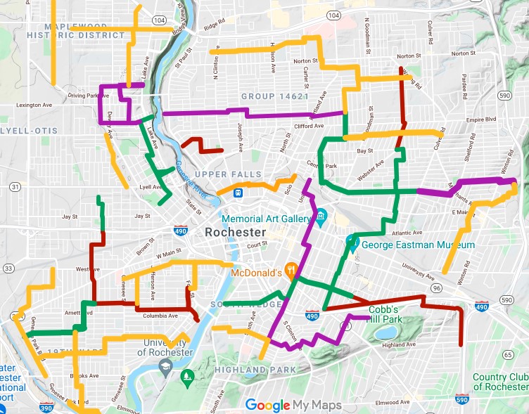
This spring, our team of graduate students and faculty at the University of Rochester’s Goergen Institute for Data Science, in partnership with the City of Rochester, set out to make data-driven recommendations for one key enabler of active transportation, the City’s bike infrastructure. We drew on a recent scientific study of bike networks in 62 other cities around the world, coauthored by researchers at the University of Rochester and the IT University of Copenhagen. We selected 86 points of interest around the City and calculated many thousands of routes among them, each along existing bikeways and streets, then located the street segments that currently lack bike infrastructure but frequently are part of the calculated routes. Those are places where new infrastructure would carry the most bike traffic and could most quickly improve users’ experiences of Rochester’s bike network. Here are the ten segments most important for bike transportation in Rochester, according to our analysis:

    • Monroe Avenue between Culver Road and Howell Street
    • Elmwood Avenue between Mount Hope Avenue and S. Goodman Street
    • Driving Park Avenue between La Grange Avenue and Saint Paul Street
    • Joseph Avenue between Cumberland Avenue and Norton Street
    • A connection between North Street and Central Park, either Davis and Scio Streets or Portland Avenue
    • State Street between Andrews Street and Smith Street
    • Smith Street between Lake Avenue and Saint Paul Street
    • South Clinton Avenue between Gregory Street and East Broad Street
    • Stone Street between East Broad Street and East Main Street
    • Saint Paul Street between East Main Street and Andrews Street

Our data-driven recommendations agree well with intuition and ongoing community conversation. Many of these street segments are also among the ten most obvious gaps in Rochester’s bike network, according to Reconnect Rochester’s Mind the Gap campaign. Many were recommended for upgraded bike infrastructure in the Rochester 2034 blueprint for growth and development, adopted by City Council in 2019. When different people using different methods tackle the same problem and find similar solutions, it’s a good sign that those could be the right solutions for the community – great minds think alike!

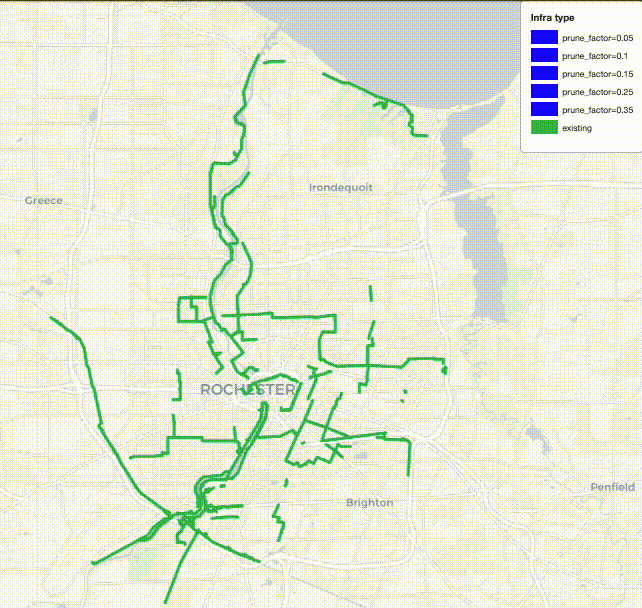
To learn more about the results and analysis that led to our recommendations, check out the interactive map below. It shows the data-driven recommendations along with existing bike infrastructure and the points of interest. You can pan, zoom, and toggle the layers. Altogether, these new segments span just eight miles (13 km) – short enough to be built rapidly and at low cost. As the map shows, they would link disjointed parts of Rochester’s existing bike network and connect it to more neighborhoods, bringing transportation equity to more residents.

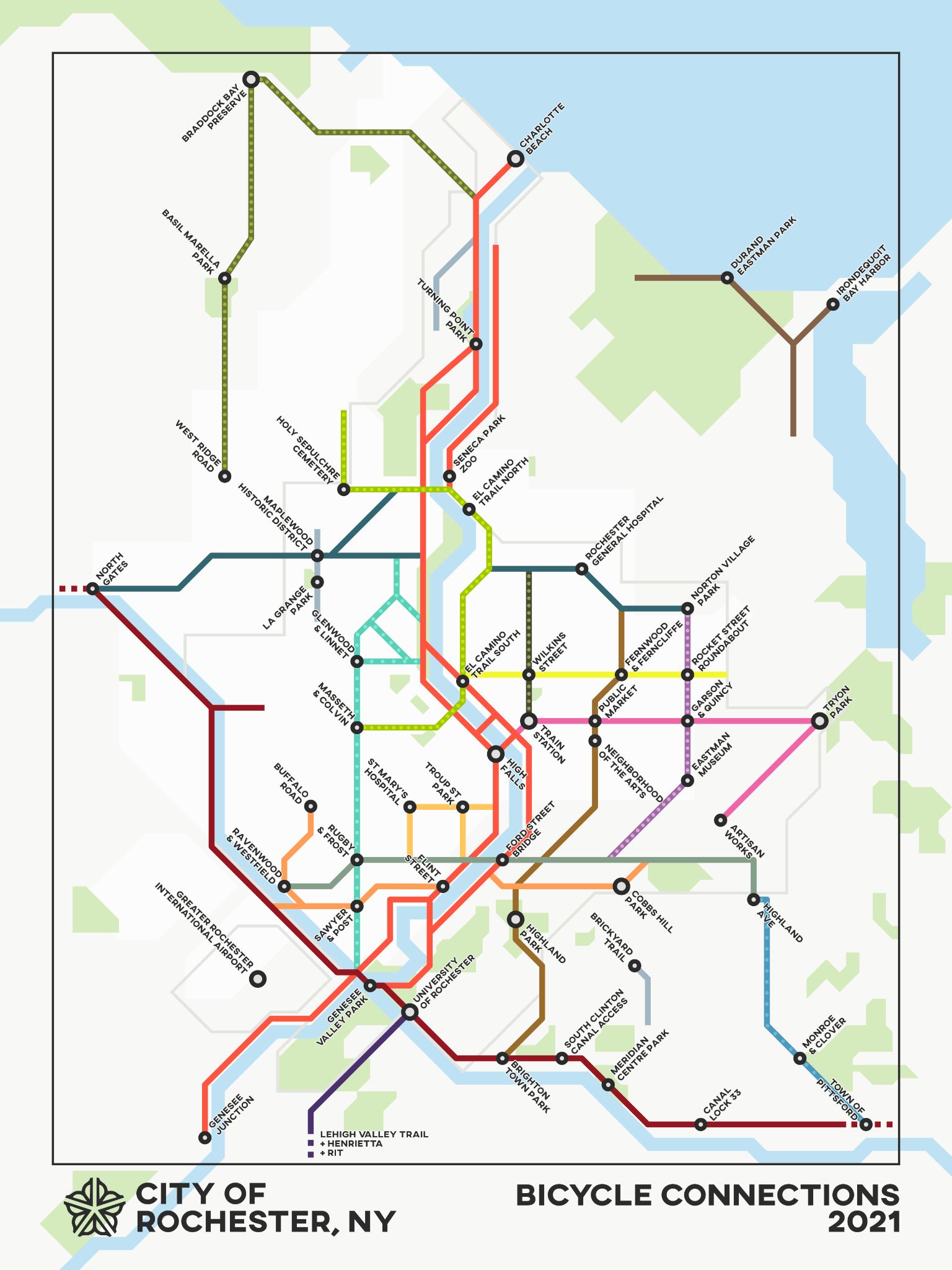
Once these ten key segments have bike-friendly infrastructure, further construction would bring further improvements, and we used the same sort of analysis to ask what should come next. The animation below shows what the Rochester bike network could look like as infrastructure is added in 12-mile increments up to 60 miles. According to our analysis, communities are best served by prioritizing dense connections in the City center along with selected arterial connections to outlying areas.

Suggested bike connections in Rochester

There’s more good news when we rate the impacts of these recommendations in terms of directness. If you’re biking from, say, the Public Market to the downtown library, the directness of your route is the ratio of the actual distance you pedal to the distance as the crow flies. A more direct route is quicker and more efficient. By averaging over all the routes among all the points of interest, the directness of a whole bike network can be calculated. The scientific study found, surprisingly, that building new infrastructure during the early part of a bike network’s development can actually make directness worse because new neighborhoods are at first connected only by tortuous routes. But the good news for Rochester is that our strong foundation of roughly 75 miles of existing protected bikeways, bike boulevards and bike paths allows us to achieve steadily increasing directness. Here, bike routes will tend to get straighter and more direct with each new infrastructure project, as long as projects are chosen sensibly.

Our analysis is all about connecting points of interest, so the results depend strongly on how those points are chosen. We started with the City of Rochester Commercial Corridor Business Data, published as part of the 2034 Plan, which tabulates 1800 locations. By looking for clusters of nearby places, we reduced that long list to 86 points of interest, which constitute parks, museums, convenience stores, schools, and other businesses. We checked to be sure that the points didn’t unfairly favor any of the City’s four quadrants or areas with higher median income. In fact, we repeated our analysis with different points of interest, chosen with a preference for serving underprivileged neighborhoods and combined the results for our final recommendations. We’ve worked hard to make recommendations that promote equity and serve all residents.

Of course, recommendations alone aren’t enough. Concrete improvements to Rochester’s bike network will require, well, concrete – as well as public will. You can help make these recommendations reality. Use this interactive map to mark assets, opportunities, and concerns that should be considered in the Countywide Active Transportation Plan. Respond to the community survey for Rochester’s Active Transportation Plan. Encourage your community leaders to prioritize bike and pedestrian infrastructure, especially when they think about big projects like ROC the Riverway and the Inner Loop North Transformation.

Kids ride on a bike path in Rochester

You can also dig deeper into our analysis by reading the full report or adapt our tools and methods to other communities by downloading our analysis code. A similar study of Monroe County would be invaluable and would be easier now that we’ve added much of Rochester’s bike infrastructure to OpenStreetMap.

With more data and analytical processing power available now than humankind has ever before known, our society is in a position to devise and execute truly excellent plans for active transportation networks. Let’s make the most of the opportunity.

No Comments

Bike infrastructure and bike education: Why it takes both to make a bike-friendly city.

By Jesse Peers, Cycling Manager at Reconnect Rochester

Let’s be honest: there are few cities out there that attract a whole lot of bike ridership without protected bike infrastructure. Whether it’s bollards or curbs or planters that are used, it’s understandable that cyclists want something between them and car traffic besides a thin stripe of paint. When protected bike infrastructure is implemented and it connects people to destinations in a low-stress manner, people use it! It is true that “If you build it, they will come”.

This protected bike lane in Portland, Maine gets residents to their Minor League team’s ballpark. Wouldn’t it be great to bike to Frontier Field like this?

It’s also critically important to fill gaps in the bike network so it’s more usable for the average rider. As Brent Toderian notes, there’s a consensus emerging in the bike world that it’s more about quality of bike infrastructure than quantity (how many miles of bike lanes doesn’t matter as much as how safe & stress-free those miles are). The new regional bike map from the Genesee Transportation Council shows the gaps in our local bike network that lack real bike infrastructure (notice shared use lanes or “sharrows” are not counted as such) Where Rochester tends to score weakest in our regular assessments is in bike network analysis. Reconnect Rochester wants to see some continuous, non-interrupted bike routes as we approach 2034, the City’s bicentennial.

Rochester’s fragmented, piecemeal approach to bike infrastructure installation results in a disjointed “network”

Another key to creating safe roads for riding is messaging to motorists that cyclists have a right to the road. Obviously, drivers harassing cyclists, telling them to “get off the street” doesn’t lead to a very bike-friendly city! We’d love to see every municipality use Bike Month and Bike Week in May not just to tokenly celebrate biking, but a time to get mayors and supervisors in front of cameras and tell motorists this important message: “Cyclists have every right to the street. We want more residents on bikes. More trips by bike helps us meet our goals. Pass them safely and courteously.”

Order a free lawn sign from the Drive2bBetter campaign today!

So we’ve established that protected bike lanes are essential to a bike friendly city, and we’ll keep advocating loudly for them. But there’s no need to keep your bike in your garage gathering dust as you wait for Rochester to become the Copenhagen of North America. You don’t have to wait for some future version of Rochester to appear, and here are some reasons why:

Rochester isn’t a cruddy city to bike in. Many local riders concur and Dan Kamalic wrote a great blog last year observing how pleasant he finds Rochester to bike in compared to other cities he’s lived in. Rochester was rated a Bronze level Bicycle-Friendly Community in 2016 and 2020 (after making honorable mention in 2012), which means we’re a good/decent biking city already. Bronze is nothing to sneeze at; it’s a result of over a decade of intentional investment. We’ve made progress since the City made its first Bike Master Plan in 2011.

There’s absolutely room to improve (we’re not content to remain at Bronze) but cruddy cities to bike in don’t get ranked and recognized. Besides, there are parts of our report cards that Rochester scores very well in such as riding groups and bike events. We’ve got a great cycling community here! Plus we have some of the best trails in the country.

Painted, unprotected bike lanes are still very safe (even though they can be uncomfortable or obstructed at times). Most cyclists’ greatest fear, which is understandable, is getting hit from behind as they bike along the right side of the road. One would assume that with a city of bike lanes without physical separation from motor traffic, that cyclists getting hit in bike lanes would be a common crash scenario. Fortunately, such crashes are extremely rare, here and elsewhere. 

Though some bike lanes could certainly be upgraded, protected bike lanes aren’t necessarily required everywhere. It’s a good bet that our city of the future, like many cities, will feature a mix of protected bike lanes, cycletracks, unprotected bike lanes, bike boulevards and trails working together to form a network. Some highly respected figures in the bike planning world only insist on hard separation from motorized vehicles when speeds hit 30mph. Therefore reducing speed limits and keeping drivers accountable to that speed limit is a great, proven way to make cyclists safer and grow ridership.

In 2021, the City greatly expanded its Bike Boulevard network. There is now a usable low-stress bike network in Rochester that enables you to get around much of the City without the need to bike on busy arterials. The Bike Boulevards primarily stick to residential side streets that have been traffic calmed and connect to existing trails.

Protected bike lanes are awesome but they aren’t a substitute for some basic traffic negotiating skills on your bike. No quality level or amount of bike infrastructure will ever alleviate the need to follow the law, maintain traffic awareness, and abide by some best practices when riding. Even if protected bike lanes proliferate, there will never be protected bike lanes or trails all the way to your destination. You will have to mix it up with traffic some of the time.

That’s where our bike education classes come in. Cycling doesn’t have to feel like swimming with sharks! In our fun classes, you can get the knowledge and confidence to enjoy cycling more. And a big part of being less stressed as you ride is learning to ride in such a way that limits motorists’ most dangerous choices. You can take drivers’ most dangerous cards off the table much of the time. It took taking a class for me to get comfortable biking and I suspect that’s probably true for most people. 

You don’t need an encyclopedia’s worth of knowledge to bike; just a handful of tips that really change road dynamics and interactions. I don’t believe a day will ever come when cyclist education isn’t necessary because the bike infrastructure is so awesome. The most bike-friendly cities and countries in the world do a great job of educating cyclists and it starts when they’re very young.

Another reason you should not wait for a city filled with bike lanes: Protected bike lanes and cycletracks aren’t necessarily cure-alls since they can still leave you vulnerable at intersections (where most crashes occur) and at driveways/parking lots. Again, this means that some traffic negotiating skills and awareness are still/always needed. We’ll explore at another time that there are ways to construct intersections much safer for cyclists, and we hope Rochester will pursue these kinds of bold design solutions in the future.

One future possibility for Rochester’s West Main Street: a protected intersection!

So when it comes to bringing about a better biking city, which is ultimately what my job is about, I’m a both/and guy. I’m both pro-protected bike infrastructure and pro-education. It takes both to move the needle and create a bike-friendly city. So get your bike out this spring, and I hope to see you at a great community ride or event. If you want to take one of our classes in 2022 to get more comfortable, reach out and let me know. We encourage you as the City of Rochester and Monroe County create their first Active Transportation Plans this year, to be engaged in the public input process and advocate for better bike infrastructure.

4 Comments

In Praise of the Improved Auburn Trail

By Jesse Peers, Cycling Manager at Reconnect Rochester

A Major Upgrade

Perhaps no place in the Rochester area epitomizes post World War II car-oriented development and suburban sprawl like Pittsford Plaza. Though Monroe Avenue is on a bus line, it’s always been a difficult, time-consuming or intimidating destination to get to without a car.

Several years ago I biked on the Auburn Trail to Pittsford Plaza and it was rough! The trail, a former rail corridor, was just too bumpy for most bikes. But with the recent improvements to the Auburn Trail, the plaza, its restaurants, shops, movie theatre, and of course places of employment are now quite accessible by bike! And because the start of the improved portion of the Auburn Trail is right next to one of the City’s Bike Boulevards (this connectivity was intentional), Pittsford Plaza is definitely bikeable from the City now. Once again, here’s Stefan Korfmacher’s stylized version of Rochester’s bike connections, only incorporating trails and bike boulevards.

Our Journey

On a warm, sunny weekend in October, I convinced our kids, ages 14 and 11, to ride out to Pittsford Plaza with me. Of course I resorted to bribery; they knew some surprise at journey’s end would make it worth their while. Hint, hint, it rhymes with “Joe’s.”

To begin, we biked from our home in North Winton Village to the ABC Streets neighborhood near Park Avenue. The City’s oldest Bike Boulevard is along Harvard Street and connects this neighborhood to Cobbs Hill via the bike/pedestrian bridge over 490. Bicycling along Rochester’s Bike Boulevards is a fun, relaxing experience. The traffic is sparse and slow due to the traffic bumps and the falling leaves on this day made it even better. Plus, regular signage helps cyclists find their way.

The pedestrian-bike bridge over 490 is so much fun! When you get to the other side, you can turn right to go to Cobbs Hill Park, Lake Riley, the dog park, and ball fields. The Rochester Chess Center is here, too, on Norris Drive. We went left on Hillside Avenue, which is another Bike Boulevard on a slow, comfortable, residential street. The boulevard continues past Winton and curves south, ending at Highland Avenue. This is where some brief on-street traffic negotiating is unavoidable. We had to take a left on Highland and bike just past 590. Even though there’s no bike infrastructure on Highland, the shoulder is plenty wide and comfortable and there wasn’t much traffic. When you’re on the other side of 590, the Auburn Trail begins just after Village Lane. The distance between the end of the comfortable Bike Boulevard and the Auburn Trail? 0.1 mile! Piece of cake.

More About the Trail

The Auburn Trail is a treasure! You bike past beautiful gardens, Council Rock Primary School, The Harley School, and the future site of Whole Foods. (TIP: As with all gravel riding, you’ll have an easier time and more stability by shifting into a lower gear on your bike so you can pedal faster.) The crossings at Elmwood, Allens Creek Road, and Clover were a breeze and motorists came to a stop every time to let us cross. A couple of the crossings feature Rectangular Rapid Flashing Beacons (RRFBs) to make crossing easier.

End of the Line (for us)

We ended our trip at Moe’s Southwest Grill, where we grabbed lunch. Our entire trip from North Winton Village to Moe’s was less than 6 miles, about 35 minutes of fun, comfortable cycling. (If you’re starting from the Colby Street bike/ped bridge in the ABC Streets neighborhood, the trip would be just 3.6 miles, about 20 minutes by bike). The property didn’t have a bike rack so we just locked up to some signage; not ideal but it works.

Less than ideal bike parking at Moe’s

After some burritos and queso, we biked across the street, through one of the Monroe Ave intersections with a traffic light, to Pittsford Plaza and Barnes and Noble. B&N has bike racks right next to the front door. With a lot of eyes on the street and foot traffic, it’s a very safe place to lock up your bike.

Bike racks at Barnes & Noble

Thanks Rochester, Brighton, and Pittsford for making this bike trip so delightful!

Additional Notes:

  • Thank your Brighton and Pittsford leaders for this collaborative effort on the Auburn Trail.
  • Pittsford Plaza and its environs could certainly use more bike racks. Now that this popular destination is bikeable, it’s worth getting in touch with Wilmorite and politely requesting that more racks be installed throughout the plaza.
One of the few bike racks in Pittsford Plaza, at Trader Joe’s
  • Though we stopped at Moe’s and Barnes & Noble, the Auburn Trail does continue all the way to 96 and the Pittsford Farms Dairy! The trail ceases to be crushed gravel and becomes a narrow dirt trail. But it’s absolutely bikeable if the ground isn’t soggy. No special bike required. For riders seeking a longer recreational ride, try: the Auburn Trail out to Pittsford > the Erie Canal Trail west to Genesee Valley Park > the Genesee Riverway Trail north up to downtown; it makes a wonderful triangle.
In 2022, we’ll feature more blogs like this – hoppable trips by bike. We hope it inspires you to leave your car at home for some trips and that you gain an appreciation for our budding bike network and trail system.
1 Comment

“Flower City Feeling Good” Summer Group Rides: Building Community & Learning Road Lessons Along the Way

By Jesse Peers, Cycling Manager at Reconnect Rochester

After taking a bike class in 2013 which made me much more comfortable biking around, in 2014 I adopted the bike as my primary mode of transportation. Since biking short distances was easy and fun, it wasn’t long before I wanted to ride with other people. In May 2015 I took our son and we went on our first group ride: a tour of public art as part of RoCo’s Ride It exhibit. Riding in such a large group was euphoric! I knew I wanted more.

That summer I started attending the weekly Unity Ride at Bulls Head Plaza, then in its first season. The people, the diversity of the crowd, and the Unity Ride’s message – cyclists coming together to stand for non-violence and community – kept me coming back each week. I also started attending the City’s Tuesday Guided Bike Tours sponsored by the Recreation Department. That’s how I got to know Richard DeSarra, who was leading those rides at the time. For decades, Richard was the godfather of all-things-cycling in Rochester. If there was anything happening related to bikes, he had his fingerprints all over it. Most notably, he cofounded the Rochester Cycling Alliance with Jon Schull and was instrumental in the creation of Rochester’s first Bicycle Master Plan.

Richard was a perfect bicycle tour guide. Not only was he a natural at herding a large group of cyclists across the city, but he just knew so much about local history, architecture and culture that anywhere we went, I’d learn something new. It was through those Rec Dept guided bike tours that I got to know Rochester by bike, particularly the Genesee Riverway Trail and other scenic locations.

Eventually Richard’s health started deteriorating and he wasn’t able to lead the tours anymore, though his advocacy and leadership continued until he passed away in 2019.

For several years, Oscar Wilson led the tours and did a great job growing the community. As with many things, the pandemic threw a wrench in those weekly tours and this year, the Recreation Department felt it was time for a reboot of sorts. The City reached out to Reconnect Rochester to see if we’d be interested in organizing and leading the weekly tours. We jumped at the unexpected opportunity and asked longtime collaborator Exercise Express and R Community Bikes to help.

We changed the night to Wednesdays and decided to use these fun community rides to familiarize residents with bike infrastructure, and to focus the tours on the newly expanded Bike Boulevard network.

For those unfamiliar with bike boulevards, they are a low-stress network of mostly residential side streets that parallel busy arterials. Traffic calming measures such as speed bumps are installed to slow down and even deter car traffic, so cyclists have a better experience. Over time, wayfinding signage will be added for cyclists. Until this year, Rochester barely had any Bike Boulevards. Many are probably familiar with the first in the area: the Harvard/Canterbury boulevard from Hillside Ave/Cobbs Hill to Monroe Ave.

In 2021, the City added 20 miles to the network! When you include the next phase of boulevards (the yellow routes above, which are absolutely cyclable now!), the future Running Track Bridge connection, and pre-existing trails, you end up with a bike network like this:

Thanks to Stefan Korfmacher for creating this stylized map for us to generate interest and discussion. Click here for a key.

Here is the best thing about the Bike Boulevards: They are Rochester’s first and up to this point only centrally planned bike network. Whereas bike infrastructure on arterials is too often done in piecemeal fashion “where feasible” with no overall view to connectivity, the Bike Boulevards are the first instance of Rochester zooming out and implementing a centrally coordinated plan to connect the city. As a result, from one end of a particular boulevard to the other, there are no gaps. Keep in mind these boulevards cross major, busy streets but for the most part avoid cycling along them.

It’s important to note that the City views these bike boulevards as complementary to, not substitutes for, on-street infrastructure on arterials. But the boulevards in large part can get you where you need to go within the city comfortably as long as you’re willing to go a little bit out of your way. Someday the network could expand to look like this.

Our hope over the summer was to build up bike traffic along this growing network ahead of time and amp up excitement for construction. We rode from a different Rec Center each week and each ride was about seven miles so it could be comparable in length to other community rides like the Unity Ride. Over the course of the series, we were able to show how these various routes connect with each other to form a usable network. Here are all of our different rides over the summer combined in one image.

Map courtesy of Bob Williams at Genesee Transportation Council

Great emphasis was put on the City’s north side, where not much bike infrastructure is present and where many Rec Centers were kept open during the pandemic due to the vital support they provide to their surrounding communities. Participants enjoyed riding along the east-west boulevards in this area that serve as wonderful alternatives to Norton, Clifford, and Bay.

Though we weren’t able to ride every boulevard this summer, you can see how these low-stress routes really do connect the City! From our marker campaign, we knew residents wanted an easier way to bike to the Zoo and to the Public Market. Well, this bike network delivers! The El Camino Trail, which you can get to via bike boulevards, ends at the Seneca Park Zoo and the Public Market is approachable via bike boulevards from all four directions!

The best part of the series was having participants ride through neighborhoods they had never seen before. Maplewood and 14621 just west of RGH got a lot of love. To my surprise, participants’ favorite ride was the longest one with the most hills! To wrap up the series, we stopped by Exercise Express, which is situated on the Ames Street bike boulevard, for some treats. Along with some group photos, here is some of the neat stuff we spotted along our journeys: