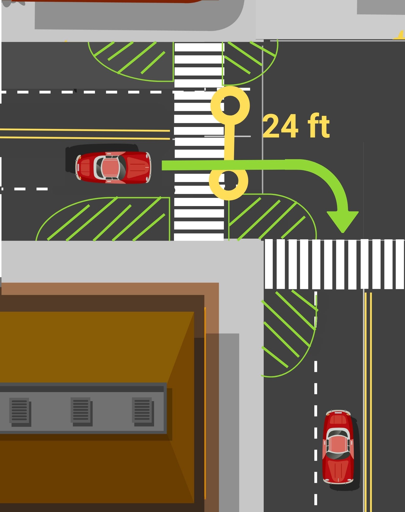
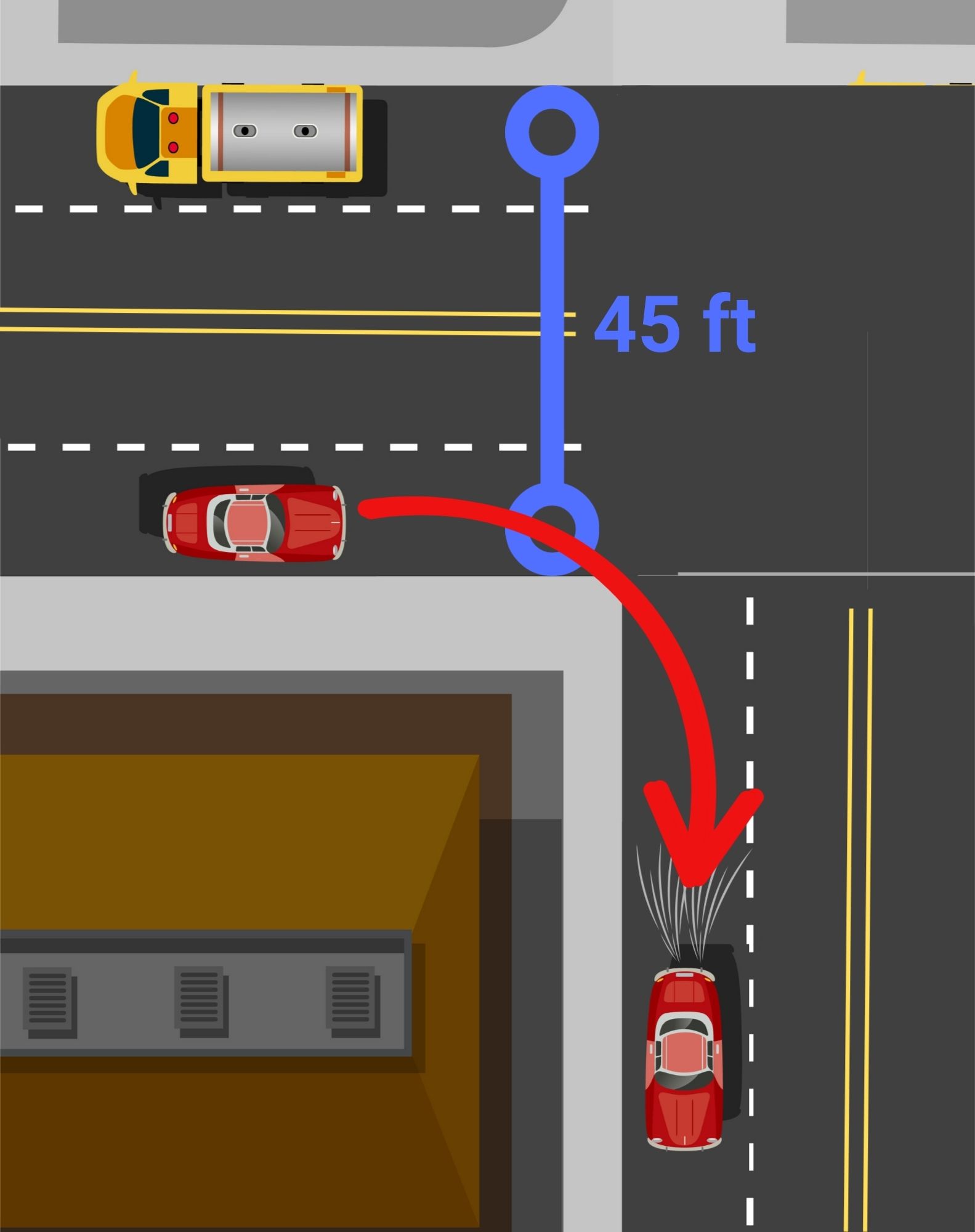
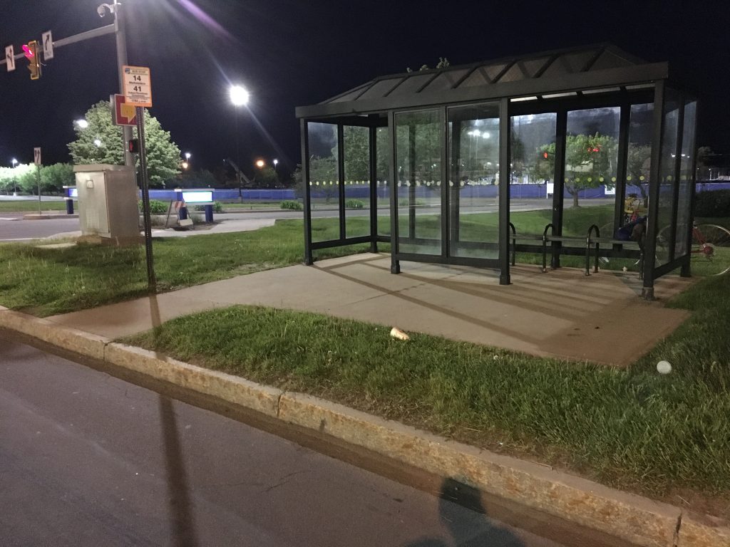
The main goal of curb extensions is to slow down turning vehicles by narrowing the space available and shorten the distance that pedestrians have to interact with cars in the road. Following the installations, more than two-thirds of survey respondents said they felt safer crossing at these intersections. Perceptions of safety emerged as the strongest indicator from last year’s project that the improvements are making a difference while adding a splash of creativity to downtown Rochester.
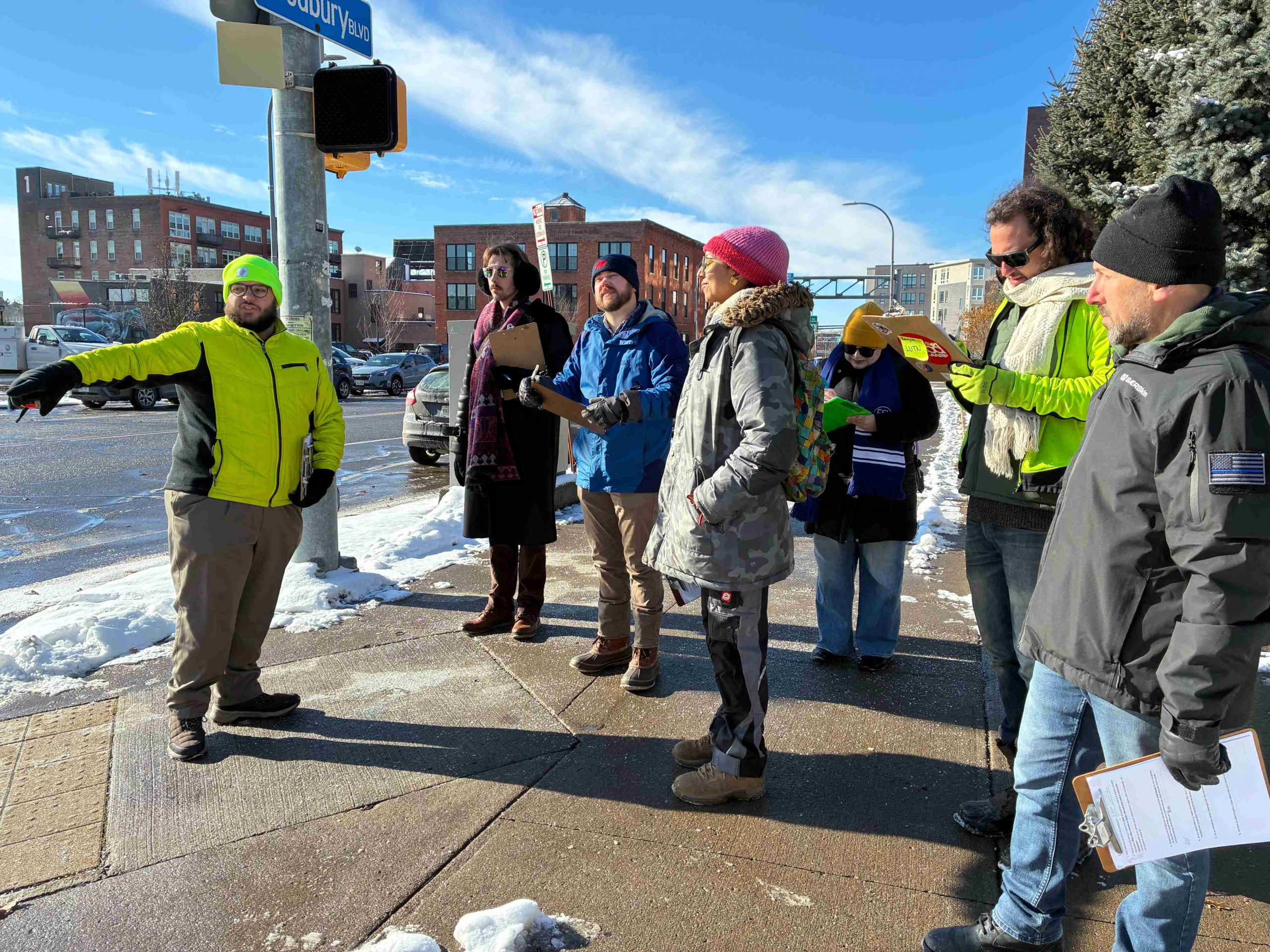
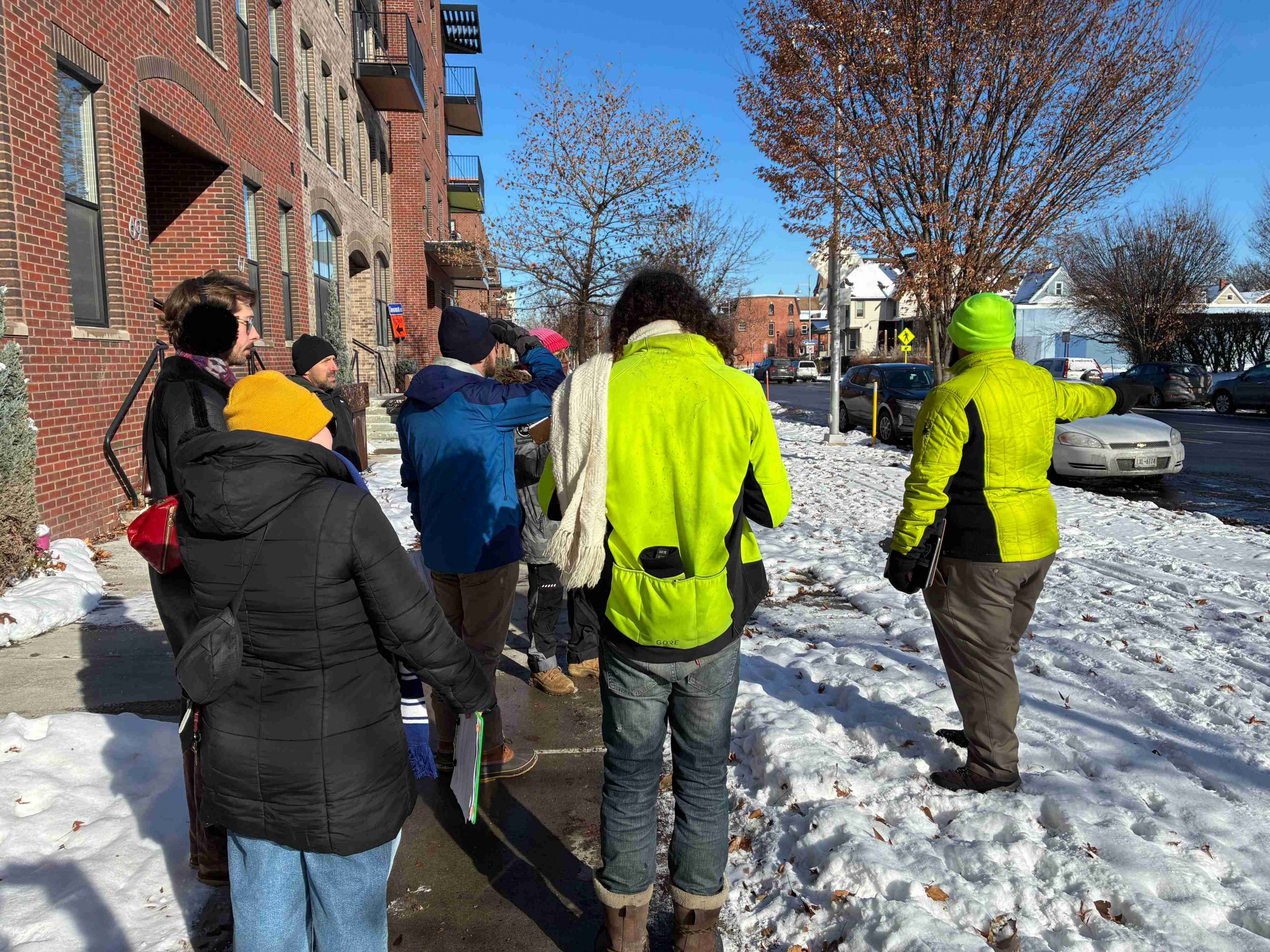
Using lessons learned from last year’s debut of the project, our Community Advisory Committee (CAC) met again in late 2025 to walk through downtown and assess potential locations for the next two installations. As we explored the streets together, we discussed areas with safety concerns and places with the greatest potential for improvement. We also considered pedestrian and vehicle traffic, along with proximity to busy downtown spaces.
Without Further Ado, Our Selections!
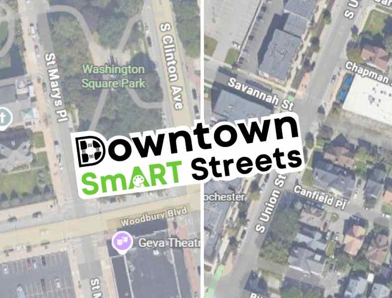
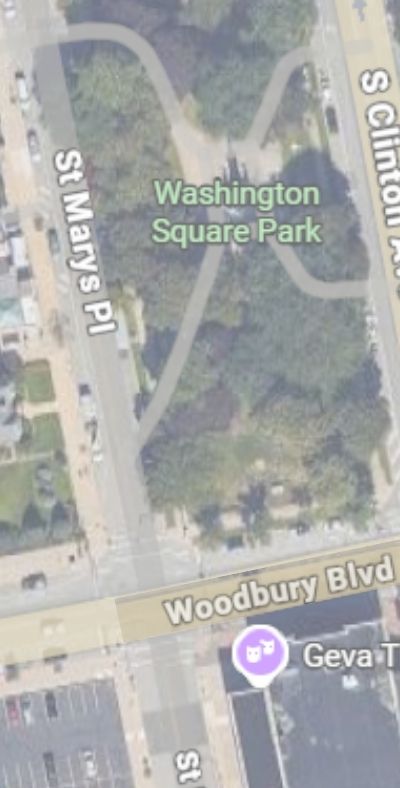
Woodbury Blvd & St Mary’s Place
And
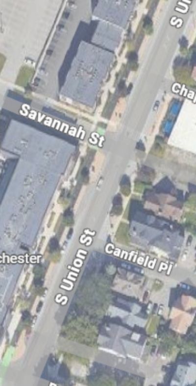
S. Union, Savannah, & Canfield Place
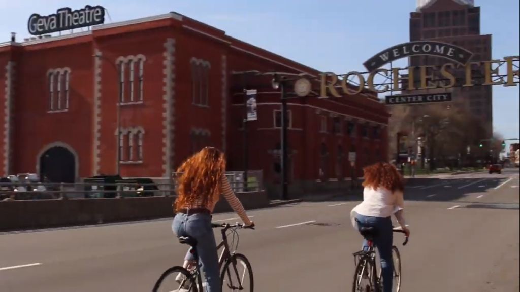
Why Woodbury Blvd & St Mary’s Place?
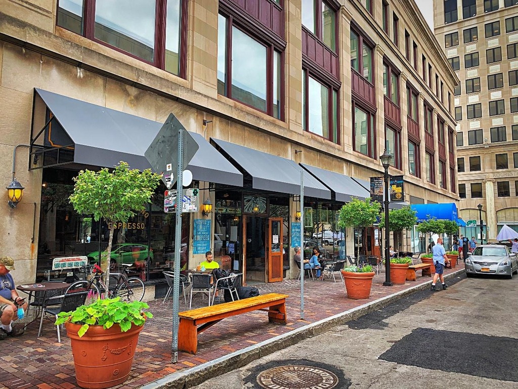
Woodbury and St. Mary’s offers a clear opportunity to redesign the streetscape and better allocate space. Plus three of the four corners of this intersection are home to Washington Square Park, Geva Theatre, and St Mary’s Catholic Church; with all the various programs that draw people to those places.You can also find Fuego Coffee just a hop skip away. This project will create a more comfortable crossing for the many visitors and downtown residents who pass through the area on foot.
Why S. Union, Savannah, & Canfield Place?
While we love the Union Street cycle track, this long, unsignalized, stretch of road offers little to deter high driver speeds. In turn, residents of S Union Street apartments, Strong Museum of Play visitors, as well as customers walking or rolling to places like Spotted Octopus, Fattey Beer Co, or Nerdvana, often struggle to find safe gaps in traffic when crossing.
These concerns became even more urgent after a tragic hit-and-run pedestrian fatality in June 2025. A driver hit 70 year old Henry “Hank” Brown, long time doorman at Salinger’s, while he was crossing S. Union walking home from work. This tragedy was a factor in including Canfield intersection where Hank was hit and killed, in the project area. While the west side of the intersection already has a substantial bump-out, the east side could be improved to harden daylighting zones and prevent illegal parking.
Next Steps…
The design team at GPI is creating renderings to redesign the project area for a safer and smarter street. Renderings for both locations will be reviewed by Rochester’s Traffic Control Board. Once the street safety design and artwork for the murals receive proper approval, we will gear up to bring these concepts to reality this spring/early summer!
We need volunteers for this project! Want to help us paint?! Reach out to project manager, Lourdes Sharp (Lourdes@ReconnectRochester.org, 585-210-9716) to explore opportunities.
We will also be updating the paint and reinstalling the delineator posts for both of our 2025 installations at E. Main & Gibbs Street and Broad and Fitzhugh! Have you visited one of these installations from last year? Let us know what you think!
As winter loosens its grip on Rochester, I’m eager to get outside and enjoy the sunlight of longer days. Many of my cherished fair-weather memories share a common thread: the terrace and the plaza. Internationally, outdoor drinking and dining are cultural institutions. Town squares and city streets around the world are packed with tables. The air is filled with the sounds of conversation and the smell of fresh food. City planners and community members are intentional about creating safe, calm oases within the urban context to eat, drink, walk, and socialize.
Sadly, this experience is not the norm in our city. With so much of our public realm surrendered to travel lanes and parking spaces, there is little space left for people. Even downtown and in entertainment districts like Park Ave, cars are prioritized while humans are pushed to the margins. Where outdoor seating is available at all, it often encroaches onto already too-narrow sidewalks, creating conflicts between diners and pedestrians. And if you can find outdoor seating, it is frequently located within just a few feet of high-speed car traffic, with all the accompanying noise and fumes.
While I see this situation as a tragedy, defenders of the status quo insist that allocating valuable urban space for outdoor dining and recreation is pointless in a city like Rochester which is gripped by snow and ice for 3-4 months of the year. While on the surface this argument sounds logical, our neighbors to the north see things differently.
City streets around the world are packed with tables. The air is filled with the sounds of conversation and the smell of fresh food…in our city if you can find outdoor seating, it is frequently located within just a few feet of high-speed car traffic with all the accompanying noise and fumes.
Every year during the winter months, the city of Montreal, Quebec is pummeled by an average of 83 inches of snow, with average temperatures below 20 degrees Fahrenheit. To put it in perspective, that is almost as much snow as we get in Rochester with a lower average temperature! But rather than basing decisions about urban space for the whole year on the coldest three months, Montreal has a different philosophy. Every summer, they open up some of their most vibrant city streets for walking, biking, and outdoor dining. Local artists and community members are called in to beautify their thoroughfares with planters, murals, and street furniture.
Despite our smaller population, I think this is something we could emulate in Rochester; perhaps from the beginning of the Jazz Festival in June to the end of the Fringe Festival in September. Partnerships could be created with these festivals, as well as other events and local businesses, to active the newly available public space. Here are my nominations for Rochester Open Streets.
Gibbs Street between Main Street and East Ave:
Located directly in the middle of the Eastman School of Music campus, this is area is the closest thing that the prestigious college has to a “quad.” A pedestrianized Gibbs Street would act as an extension of the existing pocket park on the corner of Main and create enough space for small outdoor concerts. It would also allow expanded outdoor seating for Java’s Café, Ludwig’s Center Stage Café, and Max Chophouse; all of which front onto this section of Gibbs.
Elm Street and Cortland Street at Parcel 5:
Parcel 5 has been growing in popularity as a venue for events and public gatherings; however, Elm and Cortland currently separate it from the nearby pedestrianized areas of Midtown Commons and The Grove to the southeast. Pedestrianizing these two streets would connect existing assets into a proper public square with the capacity for larger community events. It would also provide additional outdoor dining capacity for Branca, Patron Saint, and the food trucks that frequently set up shop in the area.
Park Avenue from Berkeley Street to Culver Road:
This stretch of Park Ave is home to many beloved restaurants and cafes. While I would love to see the entire length of Park Ave receive the Open Streets treatment, this section is the most obvious and least disruptive. RTS service could be shifted to East Ave during the window. Alternatively, a 12-foot span in the center of the roadway could be left unobstructed to create a temporary transit mall. This intervention would truly bring the corridor to life during some of its most vibrant months.
Which of these locations would you most like to see receive an Open Streets treatment? Is there another location in the City of Rochester you would like to see temporarily or permanently pedestrianized? Let us know!
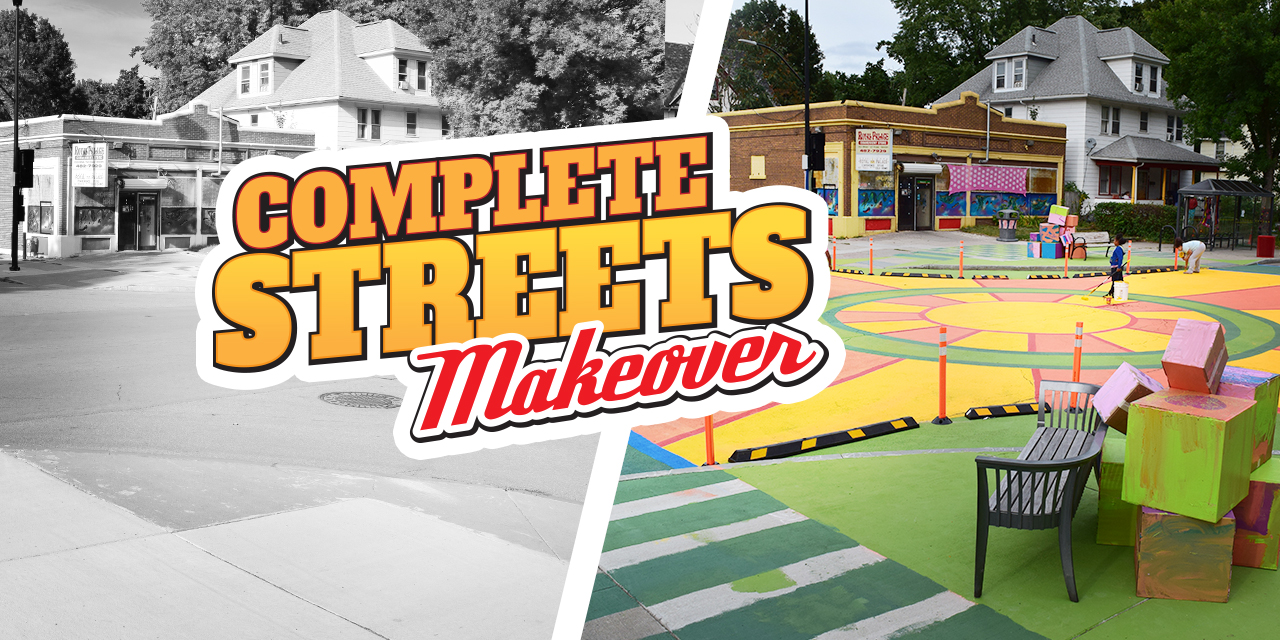
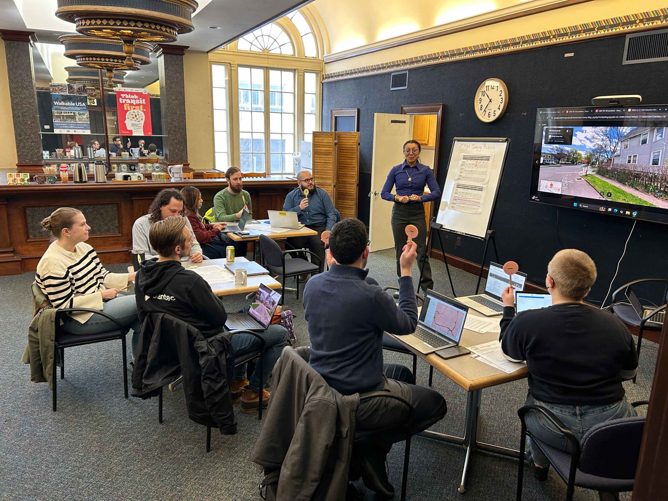
Reconnect Rochester’s Complete Streets Makeover project transforms a neighborhood intersection through a temporary installation designed to make it safer for everyone passing through, whether on bike, on foot, or in a car. We selected the winning location for our 6th project from a pool of 48 trouble spots that community members identified as places in your daily travels where you don’t feel comfortable walking or biking. After carefully evaluating each location using established criteria, such as safety concerns and design improvement potential, our Program Steering Committee held a popsicle stick voting session and landed on this year’s winner!
(Drumroll please…)
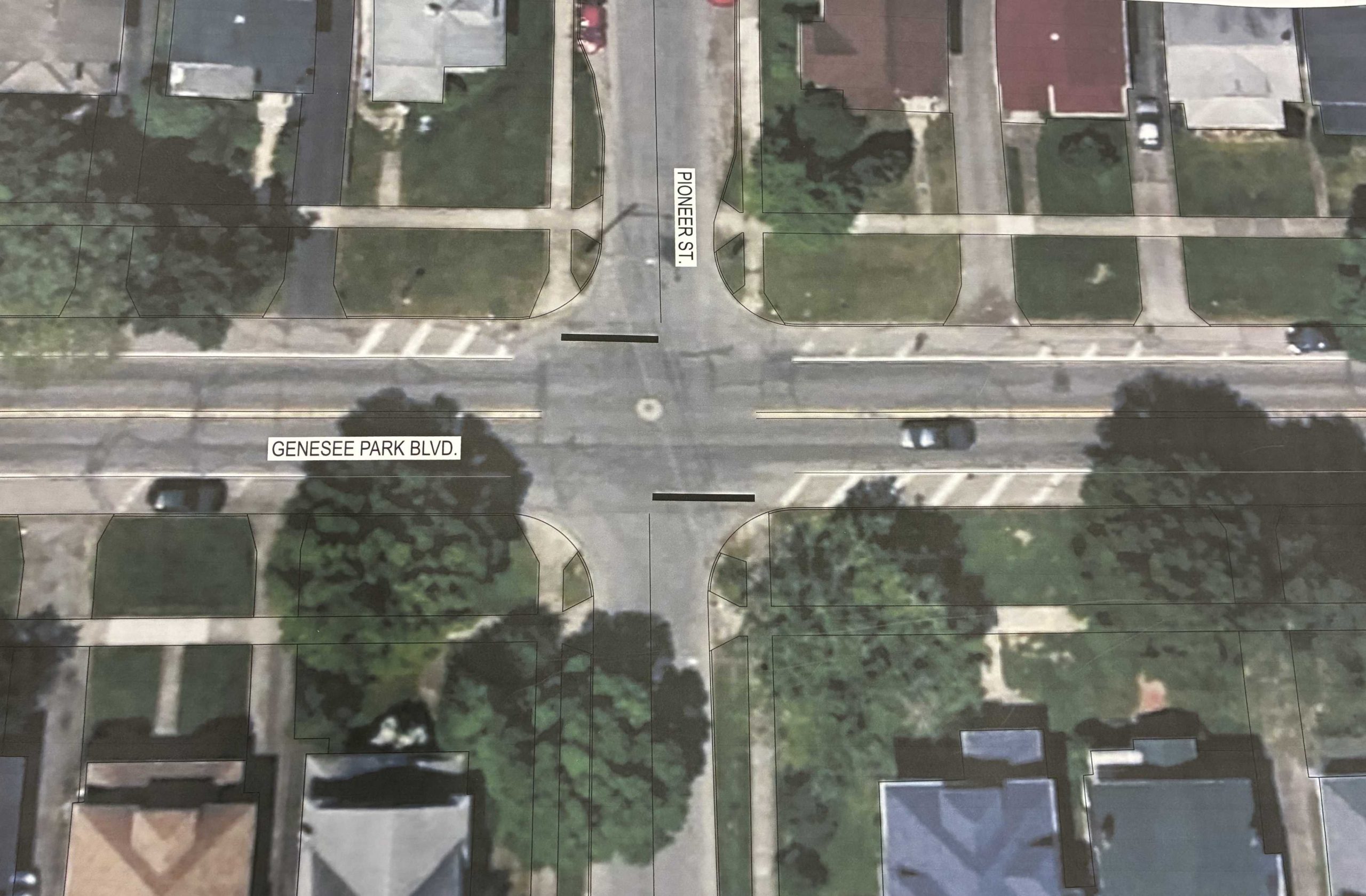
Genesee Park Blvd & Pioneer St in the 19th Ward neighborhood!
Genesee Park Blvd & Pioneer St sees a high number of crashes under normal conditions but a recent detour has exacerbated the issue. With the detour recently removed and traffic flows returning to normal conditions, residents have since raised real safety concerns traveling through the intersection.
While pedestrian crashes have been less frequent than vehicle collisions, drivers failing to yield the right of way has led to residents feeling unsafe. Some report that they take a longer route to bike or walk to Genesee Valley Park because it feels safer than passing through this intersection. Genesee Park Blvd & Pioneer St sits just steps from the Empire State Trail and Genesee Riverway Trail, where people regularly walk, run, and bike. Its proximity to University of Rochester off campus student housing and School #53 leads many students and families to rely on this intersection on a daily basis.
This intersection also has extra road space to work with, and the layout presents strong potential for design improvements. Plus, Rochester is planning a reconstruction of Genesee Park Blvd in 2032 which creates an opportunity to test safer street design on a temporary basis. Through data collection, we can evaluate what works for all road users and center community voice to help inform the permanent redesign.
Next Steps…
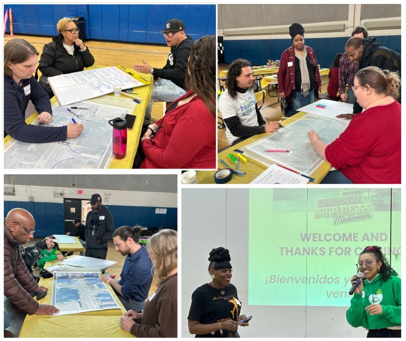
We’ll hold a Community Workshop in March to gain insight from the residents of the 19th Ward about the enhancements they would like in the intersection. No one understands what it’s like to use our streets better than those who walk, bike, roll, and ride along them everyday.
Complete Streets Makeover Community Workshop in 2025
Our friends on the complete streets design team at Stantec will use community input from the workshop to create conceptual design enhancements of an improved streetscape. We’ll then see these concepts transform into reality through a temporary on-street installation in May. This transformation is only possible through the input and support of neighborhood residents coming out to help with the installation. Keep a look out for updates along the way!
*Community Partners
The Complete Streets Makeover of Genesee Park Blvd & Pioneer St is a collaborative venture with the following community partners:
Is there an intersection or trouble spot in your daily travels where you don’t feel safe to walk or bike? Nominate it for our next Complete Streets Makeover project!FILL OUT OUR NOMINATION FORM.
Sustainability isn’t just about recycling or reducing emissions – it’s also about how we take care of ourselves and the systems that support us. One powerful, everyday way we can sustain ourselves is through active transportation – walking, biking, or using public transit. But for that to work, our communities need to be built for it.
That’s one reason I started Sustain With Age. The goal was to help people – especially in Rochester – focus on what matters to them, whether it’s running a business or caring for their families, without being burdened by unsustainable costs (like utilities) or limited mobility options. Everyone should be able to access opportunity, healthcare, and connection, no matter their income or physical ability.
And as we age, that becomes even more important.
We often think of aging in terms of healthcare or retirement, but transportation is just as critical. How do we get to the grocery store? To a doctor’s appointment? To see grandchildren? Transportation access is a social determinant of health, and yet too many communities still prioritize cars over people.
To be a truly age-friendly place, Monroe County needs to design for the future – for younger generations, but also those living longer, with changing physical needs. That means:
Safer streets with slower traffic and more pedestrian crossings.
Accessible sidewalks and bus stops with benches, shelters, and curb cuts.
Frequent, reliable transit of all modes.
A community design that reduces the need for long car trips altogether.
And numerous other measures like coordinated construction planning to allow those in wheelchairs, blind people, and others to continue to safely navigate detours.
The recent Vision Zero commitment in Rochester is a step in the right direction – it shows a recognition that lives are at stake and that we must design for safety, not just speed.
And there are more opportunities ahead. The filling-in of the Inner Loop, the possibility of higher-speed rail, and investments in more frequent bus service could all reshape how people of all ages get around. But we need to make sure accessibility and equity are at the center of that change.
Rochester has a unique role to play: we are a college town, a climate haven, a community for working families, and recently named a top city for aging in place. That mix gives us both an obligation and an opportunity to lead on sustainable, age-friendly design.
Importantly, this conversation extends beyond Rochester and Monroe County. We are a 9-county region with massive towns like Greece that need to be in this conversation and planning too.
I don’t expect a perfect system tomorrow. But as someone who works in the built environment, I see how deeply connected our homes, workplaces, and transit systems are. With smart planning and a shared commitment to sustainability – financially, personally, and environmentally – we can build a community that truly supports people across their lifespan.
Kyle is a climate risk and sustainability professional in Rochester. He is a Board Member of the Climate Solutions Accelerator of the Genesee-Finger Lakes Region and runs his firm, Sustain With Age which has a newsletter you can sign up for here. All views are his own and do not reflect those of any institution or organization.
At Reconnect, we’re always working to improve mobility access in our community. Sign up for Mobility Action Alerts for tangible advocacy and volunteer opportunities involving transportation, safe streets, and bike infrastructure.
UPDATE as of May 2025: Thanks to the efforts of Senate Transportation Chair Jeremy Cooney, the New York State Budget secured $250K for RTS to study a bus rapid transit corridor on Lake Avenue, which would lead to lower wait times and more frequent routes on one of the busiest RTS routes. This is also in alignment with the ROC Vision Zero plan!
In June 2024, Rochester Mayor Malik Evans announced the ROC Vision Zero Initiative to eliminate traffic fatalities and serious injuries on the city’s streets. Among the 10 priority actions announced was an effort to tackle Lake Avenue, one of Rochester’s most dangerous streets. The plan calls for making Lake Avenue a multimodal safety corridor equipped with a “Bus Rapid Transit” line or BRT for short. What is a BRT and why would a fast-moving bus lane make Lake Avenue a street safer? 🤔
BRT is a high-quality-bus-based transit system that delivers fast, efficient and frequent service along a corridor by implementing dedicated bus-only lanes, signal priority, bus stations with off board fare collection and elevated platforms. The City’s proposal is in early days, so we don’t have anything specific to react to, but we do hope they’ll go for the BRT Gold Standard. Gold standard BRT also includes designing for universal access for people of all abilities and pedestrian access and safety on the street. We should strive for the best and avoid what advocates have termed “BRT Creep”, when elements of good BRT are removed to save on costs and the line becomes unrecognizable from a standard frequent service line. This will take a healthy mix of up-front capital investments (to build out the infrastructure) matched with operational dollars that keep the service running frequently (for more on operating funds, see our February letter to Governor Hochul).
Only a few systems across the US have achieved bronze or better including Albuquerque’s ABQ RIDE (Gold), Clevland’s Healthline (Silver), and Pittsburgh’s Dr. Martin Luther King Jr. East Busway (Bronze). More locally, Albany’s Capital District Transportation Association has upped their BRT game with 3 BRT lines connecting Albany, Schenectady and Troy. Our friend the Urban Phoenix had a lot of good things to say about his experience using the system. Recently, a big step forward for Buffalo’s east side is the proposed Bailey Avenue BRT treatment, a 7.5 mile corridor connecting the City’s south side to north side destinations and the metro rail.
We could see our BRT line going from the Transit Center all the way to Lake Ontario, about 8 miles. Rochester’s initiative on Lake Avenue wouldn’t just add a BRT line to the existing street. It would redesign the street to enhance and advance multi-modal safety. BRT would be a component in a design that would enhance pedestrian and bicycle facilities while improving access to the transit system. While we don’t have formal designs yet, the National Association of City Transportation Officials (NACTO) thinks it could look something like this:
Planners often frame BRT as a potential catalyst transit project and on this one, we agree. BRT can offer Rochester a unique opportunity to connect Edgerton, Maplewood and Downtown with faster and more efficient bus service, and provide opportunities to invest in more transit-oriented development along the corridor. Basically, that means dense, walkable, mixed-use development near the bus stops that adds amenities closer to where people live and use the bus.
Currently, the City of Rochester is building a transit-oriented development in the Bull’s Head area where West Main St. meets Genesee St., Brown St. and Chili Ave. Local credit union ESL committed to being the first tenant in the redevelopment, bringing back banking services to the 19th Ward for the first time in a decade.
The City of Rochester identified Lake Avenue as a top transit-oriented development (TOD) corridor opportunity in the 2018 Transit Supportive Corridors Study. While improving transportation is a core goal, BRT on Lake Avenue goes beyond simply moving people. It’s a strategic investment with a ripple effect of positive outcomes:
Economic Development & Housing: BRT is a proven catalyst for transit-oriented development (TOD). By providing faster, more reliable service, it attracts businesses, housing, and services to the corridor. This is especially promising near underutilized parking areas around Kodak/Eastman Business Park, where BRT could spur valuable development and create a mixed-use hub.
Activating a Key Corridor: BRT will amplify Lake Ave’s potential, transforming the corridor into a thriving destination with increased foot traffic and economic activity.
Addressing Safety Concerns: The current state of Lake Avenue presents a barrier and many safety risks for residents accessing the Genesee River and other destinations. BRT will prioritize safety improvements for pedestrians, cyclists, and drivers, making the corridor safer and more inviting for everyone.
A Stepping Stone to the Future: BRT is not an endpoint but a stepping stone. The infrastructure built for BRT can serve as the foundation for future transit options like streetcars or light rail. This approach allows Rochester to incrementally build towards a more robust and interconnected transit network.
Safety, better transit options, economic stimulus. What’s not to like about BRT? Detractors in some places have promulgated fears that adding dedicated bus lines would create car congestion. As with most multimodal improvements, the opposite is shown to happen: Studies have consistently shown that BRT does not worsen traffic; in fact, it often improves traffic flow by prioritizing efficient transit and encouraging more people to leave their cars at home. The current levels of congestion on Lake Avenue is primarily limited to peak commute hours, and BRT will help alleviate this by providing a reliable alternative for commuters.
What’s it going to take to launch the BRT planning process? Well, RTS has gotten things off to a good start by announcing last September that the 22 Lake Ave line is getting restored to 15 minute service as was envisioned in Reimagine RTS. The next step is to get a study underway to scope the project. Lake Avenue BRT represents a transformative opportunity for Rochester. It’s a chance to create a more connected, equitable, and sustainable city – one where everyone has access to opportunity and a vibrant public realm.
At Reconnect, we’re always working to improve mobility access in our community. Sign up for Mobility Action Alerts for tangible advocacy and volunteer opportunities involving transportation, safe streets, and bike infrastructure.
We’ve been busy at Reconnect Rochester since the start of the year pursuing our 2025 Plans and Priorities. Below are a few key updates on what’s been going on in advocacy, especially those projects or events we asked you to mobilize around, and what to look forward to in the next few months:
Growing Our Movement:
Our biggest goal as an advocacy team this year is to grow our base of active, informed and engaged advocates throughout Monroe County. We’re always looking for more people to join the movement – get in touch if you are interested! We have opportunities to support multimodal transportation from taking surveys to speaking to elected officials or writing letters. The easiest way to learn about opportunities is to sign up for Mobility Action Alerts and we will send actions and events you can join.
Annual Executive Meetings:
Back in January, we held our annual meetings with Rochester Mayor Evans (City Hopes & Asks) and Monroe County Executive Adam Bello (County Hopes & Asks), setting the stage for our advocacy throughout the year, including budget advocacy that will be ramping up in the City soon. See our 2025 Budget Input submitted to the City.
ROC Vision Zero:
The Beacon’s ROC Vision Zero forum was well attended with a keynote by Mayor Evans, and an expert panel we helped assemble. Reconnect Rochester is serving on the ROC Vision Zero task force and will be participating in committees on education and community traffic safety champions in March and April.
We don’t know when the next version of the Rochester Zoning Alignment Project code will drop, but we have continued our focus on promoting transit-supportive land use that we had last year in our ZAP comments and Sprawl Effect Rochester Street Films Event. We’re continuing our focus on land use in the Transportation Impact Collective and partnering with Our Local History, Empire Justice Center, RMAPI, and the Climate Solutions Accelerator to deliver informational presentations to pro-housing advocates countywide.
Media Engagement:
Through our daily media monitoring, we are identifying problematic news articles covering crashes and sharing timely feedback using our Crash Reporting Toolkit as a guide.
Federal Uncertainty:
Last but certainly not least on our minds (and likely yours too) is the chaos and uncertainty set off by President Trump’s Executive Orders. Throughout the last two months, we have stayed in close contact with national advocacy groups such as the League of American Bicyclists, America Walks, and the National Campaign for Transit Justice. Focusing on just Monroe County, we analyzed USDOT memos and Trump Executive Orders and identified about $150 million of discretionary funding aimed at bike, pedestrian, transit and safer streets projects, already appropriated by Congress, announced, and some already under contract, potentially at risk through these orders. We have shared this information with Senators Schumer and Gillibrand and Congressman Joe Morelle, who will be meeting with Rochester cyclists in Washington during the National Bike Summit next week. Currently, we believe White House-mandated review outcomes will be announced in April 2025. We will continue to fight for resources that were appropriated by Congress and awarded to our community to fund multimodal transportation projects.
Save the Dates!
We’re excited about several things coming up:
May 1: Mayor Evan and County Executive Bello will deliver the official Bike Month proclamation at Austin Seward Plaza at 1:30 pm
In August, we asked you to help identify the intersections and trouble-spots in your daily travels where you don’t feel comfortable walking or biking, and that could be designed to be safer for everyone.
A big shout out to all those who took the time to submit a nomination! We received a total of 64 nominations for 39 locations in Monroe County.
Click here to view the nomination locations in Google Maps
Met with such esteemed and thought-provoking submissions, the Steering Committee employed the utmost levels of consideration to determine the winners for this year! After establishing criteria for both the Complete Streets Makeover Winner and the Design Rendering Winner, we reviewed each and every submission with painstaking care.
Without Further Ado, Our Winners!
COMPLETE STREETS MAKEOVER WINNER: Avenue D & Hollenbeck St in the El Camino neighborhood
DESIGN RENDERING WINNER: Webster Ave and Bay St in the Beechwood neighborhood
Why Avenue D & Hollenbeck?
Street redesign potential
High degree of safety concerns showing need for intervention
Strong community support from impassioned residents and community organizations to combat the area’s historical marginalization
We will collaborate with organizations such as the Ave D R-Center, the Northeast Neighborhood Service Center, and Ibero-American Action League to help us capture the spirit of El Camino and transform this intersection in the spring of 2025!
Next Steps…
We’ll hold a Community Workshop in February to gain insight from the residents of the El Camino neighborhood about the enhancements they would like in the intersection. No one understands what it’s like to use our streets better than those who walk, bike, roll, and ride along them everyday.
Our friends in the complete streets design team at Stantec will use community input from the workshop to create conceptual design enhancements of an improved streetscape. We’ll then see these concepts transform into reality through a temporary on-street installation in May. This transformation is only possible through the input and support of neighborhood residents coming out to help with the installation. Keep a look out for updates along the way!
Let’s not forget about our Design Rendering Winner (Webster Ave & Bay St)!
The design team at Stantec will create a conceptual drawing of street design improvements that will be given to the communities surrounding Webster & Bay. The neighborhoods can use these illustrations as a launch pad for community discussion, and a tool to help advocate for changes that would make these streets safer for everyone.
Do you have an intersection where you don’t feel safe? Although our Complete Streets Makeover nominations are closed for the year, you can always fill out the Traffic Safety Concern form from Monroe County to ask for special attention for trouble spots in your daily travels!
On October 8th, we hosted The Sprawl Effect, the latest edition of Rochester Street Films. We examined the costs and consequences of our current auto-centric land use and how we can grow our communities smarter to deliver access, vitality & upward mobility.
In the 1930’s the Federal Housing Administration provided loans to make mortgages more affordable yet the loans came with guidelines to standardize neighborhood design which directly contributed to sprawl and auto-centric infrastructure:
No sidewalks (hostile to pedestrians)
Minimum lot sizes (homes are more expensive to build and farther apart)
Separated land use due to exclusionary zoning (homes far from amenities and difficult to reach without a car)
When services are built far from homes this contributes to sprawl. It also costs more to subsidize auto-centric neighborhoods due to requirements such as more asphalt to support the parking requirements and more frequent road repairs due to degradation from heavy use. When we build transit oriented developments with a mix of high density residencies (instead of exclusively single family homes), along with commercial, office, and entertainment spaces in the same neighborhood; they financially outperform auto-centric suburbia every single time.
The diagram below from Urban 3 shows that cities are much more profitable and actually subsidize suburbs with their tax dollars. The revenue bars of the dense downtown area vs the expenses associated with sprawl is clear in the visual provided. While this graph is from Lafayette, Louisiana, Urban 3 found this phenomenon is true with every city they studied all over the country.
Presentation on Local Data & Stats
Cody Donahue, Director of Policy and Advocacy at Reconnect Rochester
Even if you have access to a car and all of the expenses that come with it, losing access to basic amenities in your neighborhood deprives it of its usefulness and its character. Our sprawling land use patterns have a substantial human cost in limiting the ability of too many of us to access what we need. This stands in the way of upward economic mobility.
Thanks to the resource Zoning Atlas, we see that single family homes can be built virtually anywhere in Rochester. Yet building higher density homes such as apartments, ADUs, or even single family homes on small lots is more restricted.
Irondequoit and Penfield data is currently unavailable.
We believe connecting Monroe County with robust transportation options and utilizing less restrictive land use will increase the vibrancy of town centers, reduce harmful air pollution, and allow seniors to age in place without relying on driving. While understanding that we need to build on what we have, before building anything new we recommend considering the following:
Using land that is located in town, village and city centers productively by building denser, mixed use buildings along transit corridors & filling in disused parking lots
Choosing development patterns that make the car and car storage optional, not the center of the design
Using new transit developments such as bus rapid transit or incentives to stimulate economic growth in areas well served by transit options or walkability
Special Remarks
Simeon Banister, President & CEO of Rochester Area Community Foundation
Land use decisions are often attributed to organizations instead of people but Homer Hoyt is an actual person who made decisions that brought us many of the problems that we have discussed today. Hoyt was the Chief Land Economist for the Federal Housing Administration who approached his work through the lens of his preconceived biases about people of color and immigrants rather than letting data itself inform his research. He is the architect of redlining which led to zones of deprivation in our community and all across the United States. Hoyt made a choice based on fear, and we can do the same or make a choice for vibrant neighborhoods that embraces smart growth in transit policy.
Moderator: Abigail McHugh-Grifa, Executive Director at Climate Solutions Accelerator
Panelists: Aqua Porter, Executive Director of RMAPI Kevin Kelley, Office of City Planning Manager Miguel Velázquez, CEO of RTS
Aqua Porter emphasized that building power, autonomy, dignity, and belonging is key to upward mobility and economic opportunity. Exclusionary zoning and car-dependent infrastructure are costly and restrict residents’ autonomy. By addressing land use and embracing dense, mixed-use neighborhoods, we can offer people more choices in where they live and engage with their communities. This shift can help reduce social isolation, fostering more connected and vibrant neighborhoods compared to the isolating, sprawling suburbs created by single-family zoning.
Kevin Kelley discussed the Rochester 2034 plan and Zoning Alignment Project, which aim to promote density along transit corridors and address land use issues. However, he cautioned that Rochester’s history with a struggling market could present a barrier to building high density projects. He also highlighted the need for more inclusive zoning in suburbs and rural areas, along with increased state and federal funding for public transit. Raising awareness about zoning problems and solutions is key to making progress.
Miguel Velázquez discussed how frequent service is crucial for robust public transit, but RTS has faced decades of underfunding, limiting its effectiveness. He noted that land use plays a role, as many people want to get by without needing a car but are scattered across Greater Rochester. Miguel also emphasized the importance of involving RTS when large companies plan new facilities, as many opt for highway-adjacent locations with big parking lots instead of transit-accessible downtown sites. To address this, the NYS Assembly and Senate are considering bills to fund transit services when companies receive tax incentives for building in the region: S8563/A9225.
Get Involved
We hope that this discussion resonates with you and that you will consider watching the program in its entirety on our YouTube channel. While you’re over there, make sure to subscribe!
Want to help more directly? Sign up for our weekly Mobility Action Alerts to stay in the loop with opportunities of how to advocate for safer streets, bicycle infrastructure, and transportation options.
Also please consider donating to support our advocacy work building a community connected by a robust transportation network that makes it easy for everyone—regardless of physical or economic ability—to get around.
Got an idea for a blog post about mobility? Contact Chaz to get started.
If you’ve ever navigated the world without a car (whether that be for necessity or recreation), you’ve probably had a, “Why can’t I get over there from here?” moment. Guest blogger, Jack Rinaldo, had so many of these “moments” that he actually wrote up a proposal for a new mixed-use trail in Irondequoit, which would connect the eastern edges of Norton Street and Ridge Road. Curious? Read on for the nitty-gritty details in his own words.
Guest Blog by Jack Rinaldo
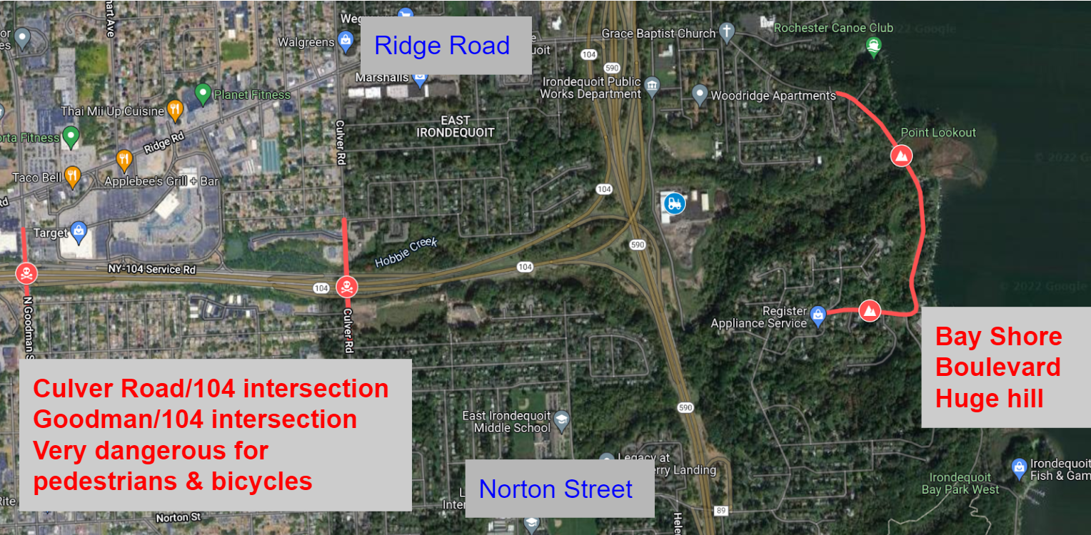
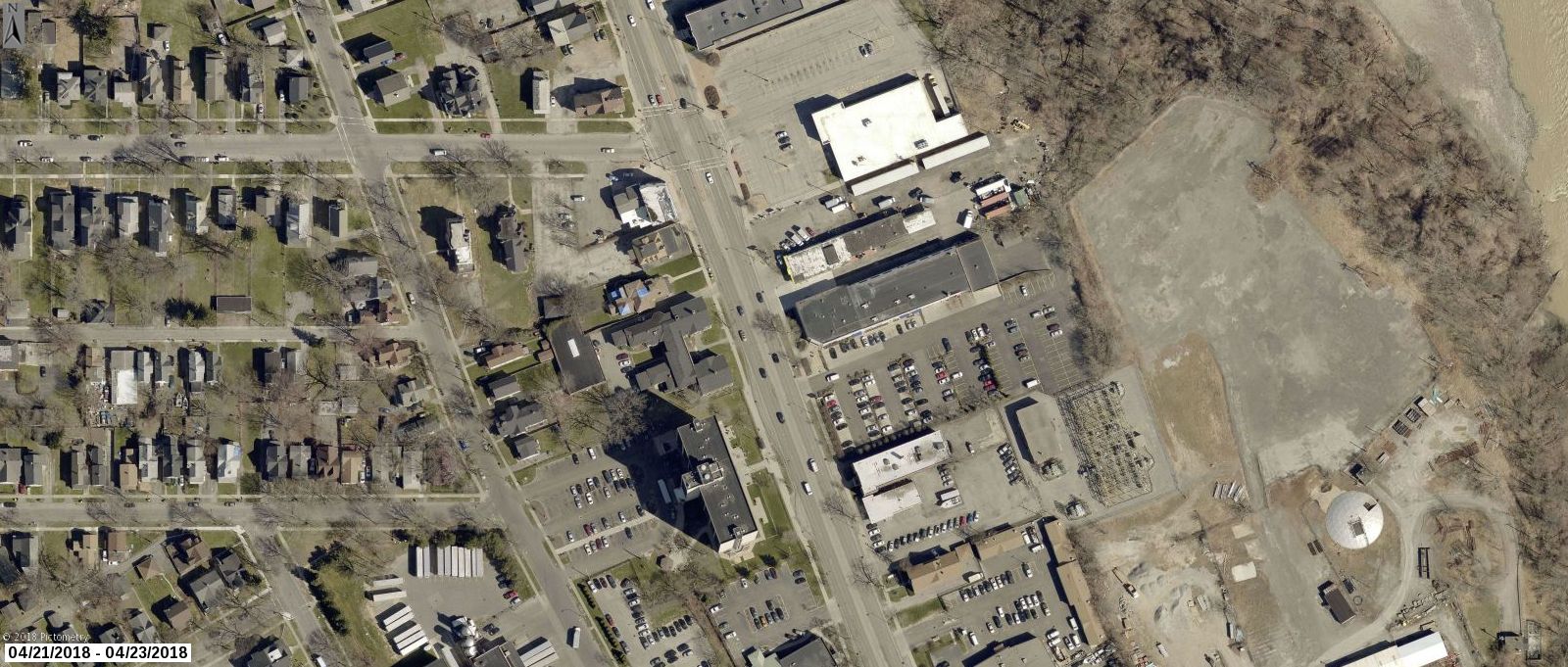
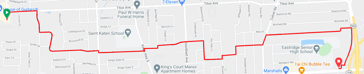
If you want to walk or bike to or from Southeast Irondequoit, you need to cross 104. There are only three locations to do so, highlighted in red in the picture below. Goodman Street and Culver Road have intersections with on/off ramps for 104. Both of these locations are dangerous for pedestrians and cyclists, no matter if they are on the road or the sidewalk. The other option is Bay Shore Boulevard. This street is calm, but it has huge hills at either end of it, making it unusable for most people.
These barriers cut off the southeast side from the rest of Irondequoit. Would you let your kids use any of the three current routes? I am an experienced and confident cyclist and I will not ride on those sections of Goodman or Culver.
The proposed new trail would run from Norton Street north to Ridge Road. As seen in the picture below, the trail would start just east of the Norton Street/590 onramp. The trail could run very close to the 590 onramp, similar to the Brooks Avenue/390/Erie Canal Trail setup as shown below. It would then run north, connecting with the road that the new Irondequoit town Department of Public Works (DPW) is on. This half mile section would potentially be the only new construction needed.
Once connected to the DPW road, trail users could use that road to reach Ridge Road. Additional sections of trail to the side of the road could be added as well if they are determined to be needed.
This trail would be similar to other local trails near highways such as the Route 390 Trail in Greece, and the Route 104 Trail in Webster.
Brooks Avenue, 390, and Erie Canal Trail
This new trail would easily connect to the Sea Breeze Drive trail as seen in the picture below. Once at Ridge Road, trail users go 1000 feet west to Kane Drive. Kane Drive is a nice calm street. Once at Kane Drive, they would proceed north until they met the Sea Breeze Drive trail at the Titus Avenue roundabout.
The new trail would also easily connect to the City of Rochester’s Bicycle Boulevards. Heading south, traveling 700 feet west on Norton Street brings you to Helendale Road. Helendale Road is another calm street. Once in the Laurelton neighborhood, use Spencer Road and Whittington Road to directly access the Bicycle Boulevard system on Farmington Road.
To connect the new trail to the other systems above, all that would be needed would be signage directing users along the route.
The newly expanded trail system would also connect all six of the schools in the East Irondequoit School district. Students and families could use the trail to access school facilities for class and extracurricular events.
Irondequoit High School is 400 feet from the Kane Drive/Ridge Road intersection, and a path to the school’s athletic facilities is on Kane Drive.
East Irondequoit Middle school is 1200 feet west of the Norton Road/Helendale Road intersection, then 500 feet up Densmore Road.
Laurelton-Pardee Intermediate School is 1700 feet from the Norton Road/Helendale Road intersection.
Helendale Road Primary School is directly on Helendale Road.
Durand-Eastman Intermediate School is almost directly on the Sea Breeze Drive trail.
Ivan Green Primary School is 1 mile away by safe neighborhood roads from Kane Drive.
The newly expanded system would connect many parks such as Irondequoit Bay Park West, Tryon Park, Durand-Eastman Park, the Lakeside Trail, SeaBreeze Amusement Park, Irondequoit Bay State Marine Park, and the beach at the Irondequoit Bay outlet.
Irondequoit can look at the successes other towns have with trails, such as the new Brickyard Trail in Brighton, as well as the continued use of miles of trail that already exist in the region. Creating the new trail would be a great opportunity for the town to take unutilized land and better connect residents and neighborhoods, while promoting healthy and environmentally friendly transportation. The half mile of construction needed to achieve all of this would be very worth it.
Filling in the northern section of Rochester’s Inner Loop presents a rare opportunity to re-knit the fabric of a neighborhood that was unjustly damaged by the era of highway construction. And if we do it right, a newly designed landscape will bring new economic opportunity, better connectivity and accessibility, and improved quality of life for the people who live there.
As the planning process for Inner Loop North heats up, now is the time for all of us to be most active, engaged and vocal about what we want to see. We encourage you to attend one of the public meetings coming up on Dec 2, 6 & 7 (details here) to ask questions and give input on the latest designs.
For our part, Reconnect Rochester has been serving on the project Community Advisory Council for several years, weighing in at every opportunity to urge planners to create a connected community with streets and spaces designed for people (not just cars). A few months ago, we submitted written input to City officials and the project design team outlining our thoughts.
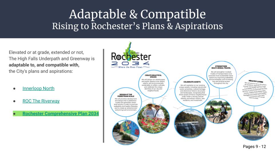
One thing we encouraged was for the City of Rochester to be open to creative ideas that come from the community. One big idea that’s been put forth is theHigh Falls Greenway, a concept developed by Jon Schull and Ben Rubin that has been endorsed by Greentopia, Hinge Neighbors & R Community Bikes. Their concept contains some stellar thinking and seriously creative ideas.
Here are Jon and Ben to tell you all about it…
Jon Schull
Ben Rubin
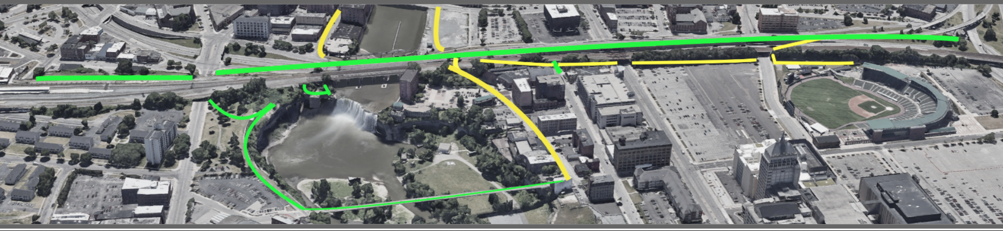
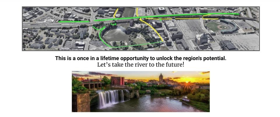
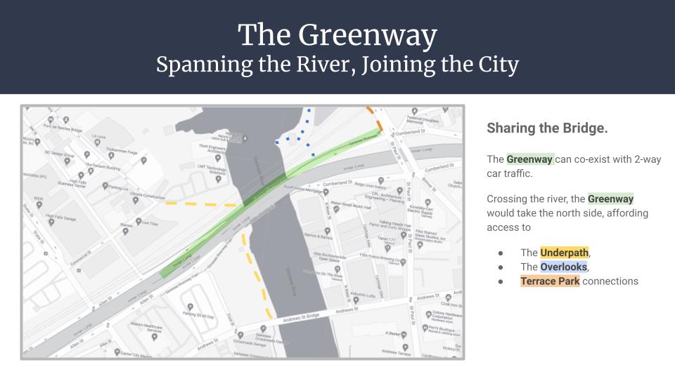
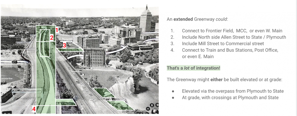
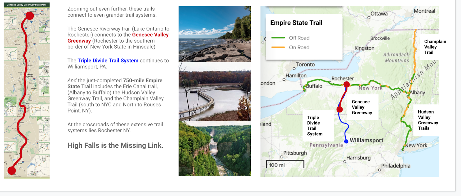
We need green, direct, car-free connections east-west across the river and north-south across the Inner Loop North. These connections can intersect and converge in a Greenway that overlooks the falls and provides functional and recreational active transport corridors that connect the downtown Riverway with High Falls, Frontier Field, and the Louise Slaughter Amtrak Station.
The Crossroads
Rochester faces a once-in-a-generation opportunity to redefine our city. Two massive urban development initiatives are underway; the ROC the Riverway projects traveling from south to north, and the east-west Inner Loop North project. Both converge at High Falls, where today an “overbuilt and underused” highway forms a pedestrian impasse obscuring one of the nation’s greatest urban waterfalls. As city planners and architects work to weave the Genesee Riverfront into “a direct trail connection to High Falls along the river,” we propose a greenway that would repurpose several lanes of the Inner Loop to fulfill the city’s aspirations. The High Falls Greenway could be the heart of an active transportation and recreational network spanning the state, advancing social equity, economic opportunities, and ecological wellness for generations.
“The successful transformation of the Inner Loop North will create new active and passive green spaces that promote multi-modal connectivity and accessibility, while also fostering opportunities for economic and community development.” – Inner Loop North Transformation Study, 2020
The city officials leading these efforts are forward-thinking advocates of active transportation, sympathetic to the principle that there should be car-free north-south and east-west corridors for pedestrians, bicyclists, tourists, wheelchairs users, and others who depend upon accessibility. A new administration, armed with funding and an ambitious 500 page Comprehensive Plan that maps Rochester’s aspirations for the next 15 years, can now turn big ideas into realities. But this can only happen with support from an informed and engaged public (that’s you!).
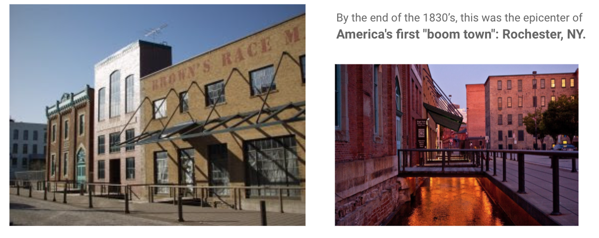
Rochester Raceway: A Retrospective
The City of Rochester, founded between a series of Seneca villages, began with a short canal called Brown’s Race. Built in 1815, the “raceway” channeled the Genesee to power flour mills at High Falls and became the epicenter of “America’s first Boom town.” Rochester’s population grew exponentially for a century, turning historical Haudenosaunee trails into roads for pedestrians and carriages, and adapted in the 1880s for bicycles. By 1900, Monroe County boasted the most extensive network of bicycle “sidepaths” anywhere in the nation with the same population it has today. Industrial giants, innovators and social activists like George Eastman, Glen Curtiss, and Susan B. Anthony all used these paths for their daily commute, along with 40,000 others.
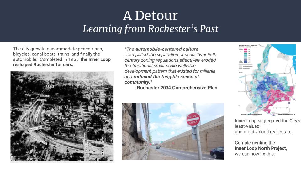
But with the explosive adoption of automobiles, a new kind of race began, with roads prioritized for cars. Pedestrians were derided as “jaywalkers,” and bicycling (still the most energy-efficient form of locomotion in the known universe) became a second class form of transportation.
In the 1950s construction began on the Inner Loop, designed to facilitate high speed automobile and truck traffic at the expense of other forms of transportation. For a decade entire districts were progressively leveled to the detriment of newly-settled black families during the final years of the “Great Migration“. Rochester’s new automotive “moat” was largely impassable for pedestrians. Residences and walk-in businesses just yards beyond the Inner Loop margins were suddenly walled off from their neighbors. Intentionally or not, city neighborhoods were divided into two separate and unequal districts. As illustrated by the map below, the Inner Loop continues to segregate the city’s least-valued and most-valued real estate.
By the time the Inner Loop was completed, Rochester was a national model for shopping malls and suburban picture-perfect Americana while at the center of race riots in one of the country’s greatest concentrations of poverty. At the height of the nostalgic Instamatic years, our industry was paving over contaminated brownfields and our politics were downplaying racial discrimination.
Nevertheless, through social, economic, and environmental challenges, Rochester became home to adaptive and resistant communities: activists and immigrants, schools and hospitals, world-renowned musicians and deaf culture. Today, Rochester is defined by the storms it has weathered and by the diversity that has gathered along the riverbanks. Our long-constricted downtown is reintegrating into the larger Genesee River Valley, returning to the natural forces that powered the city growth.
High Falls Greenway
ROC the Riverway includes more than a dozen ongoing projects to improve access to the downtown riverway above and below High Falls. Inner Loop North, the next phase in our downtown highway remediation project, intersects the riverway and aims to restore the original street grid. Together, the projects are budgeted for ¾ of a billion dollars. They are interconnected and integral to the reintegration of Rochester; a critical junction in a critical moment.
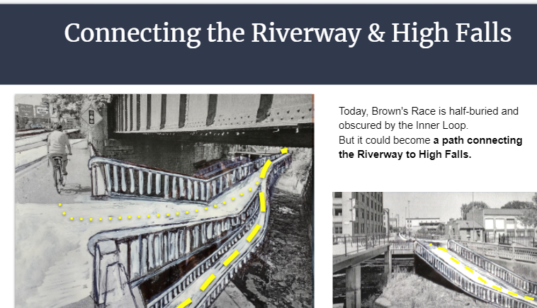
The city’s engineers have been examining Brown’s race as a potential portal to High Falls. They assured us that some kind of pedestrian through-path could be possible with the planned changes to bridge elevation. Also possible is a dedicated car-free greenway, which clearly aligns with the mission of the city. Our initial presentation offered active transportation considerations compatible with all of the city’s published plans. We are not architects or engineers, but as engaged citizens we did consider 490 connections, scenic overlooks, street integration, and a variety of extensions between West Main and East Main. Urban greenways have benefits beyond providing an alternative to automotive traffic – they can be socially transformative.
Establishing a fluid intersection between the river and the road would build community. Historically disconnected neighborhoods along the river would have front row seats to what would be our greatest tourist attraction, a revived High Falls district. Families from out of town could take the train to our new station and rent bikes to catch a game at Frontier Field, a contest at ROC City Skatepark, or a graduation at U of R or RIT. Residents could ride the greenway for regular commutes to school, jobs across town, or for shopping at the public market. Convention Center visitors, Constellation employees, and local students could stroll up the center of the city, sampling sights, sounds and fresh air from the falls. And for neighborhoods like the Hinge district, open access to equitable resources like bike and scooter stations would go a long way to reintegrating our city and engaging marginalized youth.
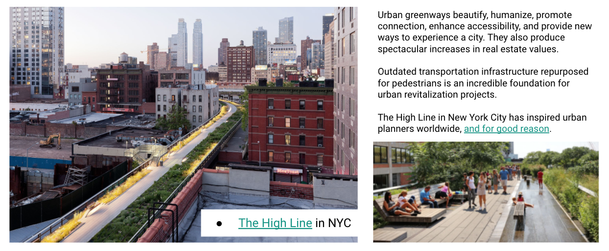
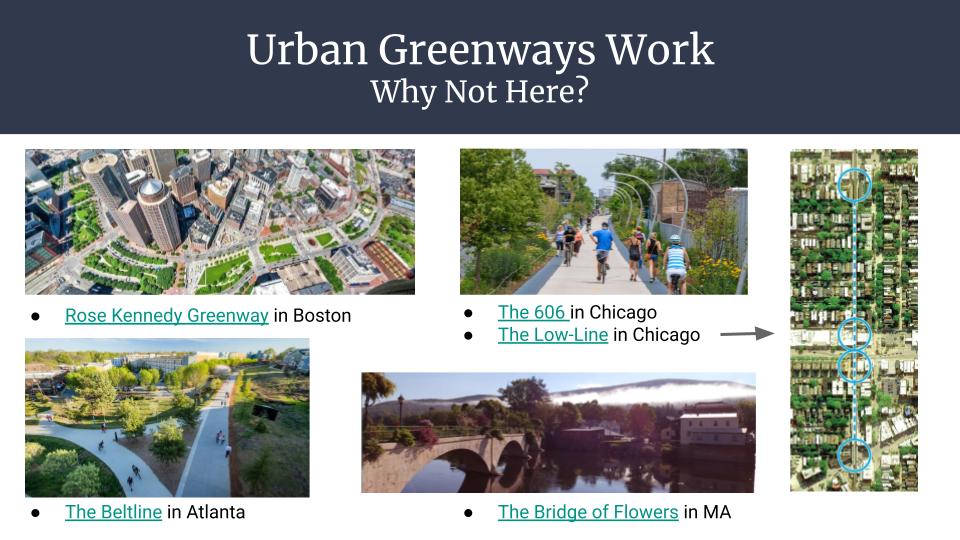
An integrated Riverway and Greenway converging at High Falls would provide spectacular returns on investment. During our meetings with city advocates, we learned that sections of the newly reclaimed Inner Loop territory are currently earmarked for high density, high value housing. But that is not the only way to increase value. New York City’s investment in the High Line, which turned the stagnant meatpacking and Chelsea districts into attractive residential, business, and entertainment zones, has recouped 900% in tax revenues alone while maintaining dedicated greenspace for active transit. From Chicago to Atlanta, it is widely documented that greenways pay.
And then there are the benefits to ecology and health. A city optimized for human powered transportation becomes cleaner, more efficient, and more livable for humans and our ecological co-inhabitants. Rochester’s river, waterfalls, gorges, and park paths blend with our existing network of tree-lined streets, bike boulevards, and statewide trails. With so many existing natural resources defining the city, we all benefit more by planning with the natural systems we rely upon.
The city is collecting feedback from residents to correct some of the past mis-steps and to create lasting opportunities and livelihoods for future generations. City Hall won’t be carrying all of the responsibility alone. Families and schools, businesses and organizations, entire neighborhoods can stand together and remain vigilant to ensure that the city’s laudable vision and well-defined aspirations are preserved.
Rochester’s past, present, and future converge at High Falls. A greenway that fully integrates the east and west sides of the river would transform the way the world sees Rochester and the way we see ourselves.
If you support a downtown greenway, spread the word. Get your neighborhood association to join those that have already endorsed the proposal. Post on social media. Join our facebook group. Talk to your representatives. And stay tuned.
In July, we asked you to help identify the intersections and trouble-spots in your daily travels where you don’t feel comfortable walking or biking, and that could be designed to be safer for everyone.
The community response was tremendous, and we thank all those who took the time to submit nominations! We received a total of 76 nominations for 68 locations in Monroe County.
Click here to view the nomination locations in Google Maps
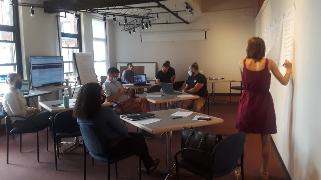
The Steering Committee had a tough task to choose from so many quality submissions and deserving locations! A set of established judging criteria helped guide us through the selection process. Here we are, hard at work examining each and every submission:
So What’s the Good Word?
In the end, we selected the following locations as this year’s winners:
COMPLETE STREETS MAKEOVER WINNER: Orange Street & Orchard Street in the JOSANA neighborhood
CITY DESIGN RENDERING WINNER: Arnett Boulevard between Genesee Street & Warwick Avenue in the 19th Ward neighborhood
SUBURBAN DESIGN RENDERING WINNER: Monroe Avenue between Highland Avenue & 12 Corners in the Town of Brighton
Orange & Orchard in the JOSANA Neighborhood will be the focus of our on-street installation
The Orange & Orchard location presented the right mix of community support, evidence of safety concerns, and potential for a street re-design that would create real, transformative change for the community through our project. We are eager to get to work with the families at School 17, Charles House Neighbors in Action, the Americorp Vista team, and JOSANA neighbors on a project to transform the intersection and create a safer space for the community.
The Steering Committee also selected two Design Rendering Winners. These locations might not be suitable for the on-street makeover project (because of their size or other feasibility issues), but we want to highlight them as places where the community would like to see improvements made.
What Happens Now? Let’s start with our Complete Streets Makeover Winner.
The Complete Streets Makeover will kick off with a community input session in January (facilitated by the Community Design Center) to hear from the residents of the JOSANA neighborhood about their experiences and ideas. No one understands what it’s like to use our streets better than those who walk, bike, roll, and ride along them everyday.
2019’s community input session in the El Camino neighborhood.
Based on feedback from this session, the complete streets design team at Stantec will draft conceptual design improvements of an improved streetscape. The design will be brought to life through a temporary on-street installation in May. We will rely on people power from the neighborhood community, and equipment from the Healthi Kids traffic calming library to lay down the temporary design on the street. Stay tuned for project updates as we go along!
What About the Design Rendering Winners?
The design team at Stantec will provide each of our Design Rendering Winners with a conceptual drawing of street design improvements. The neighborhoods can use these illustrations as a launch pad for community discussion, and a tool to help advocate for changes that would make these streets safer for everyone.
Arnett Blvd between Genesee St & Warwick Ave
Monroe Ave between Highland Ave & 12 Corners Plaza
Guest blog by Nicholas Russo; an RIT graduate, civil engineer, & passionate urbanist
On May 17, 2021, a re-imagined Regional Transit Service kicked off in Rochester. As a hired Transit Ambassador for the first week of the rollout, I had a firsthand view of how the new bus routes and infrastructure were set up and how they functioned, and also got to hear the thoughts and experiences from transit users. In this post, I’ll recount my time visiting three of the new Mobility Hubs around the metro area, as well as my car-free week in Rochester! I am currently living in Massachusetts, so I was excited to have an excuse to visit my old college town, and get paid for it!
For those who may be unfamiliar, the Reimagine RTS initiative began several years ago, with the ultimate result of more efficient bus routes, including three new Crosstown lines (which I made extensive use of during the week), and an all-new On Demandservice. The On Demand service is like micro-mass-transit, with shared vans that can be called for pickups and drop-offs anywhere inside specific On Demand zones. There are no fixed routes or bus stops in the On Demand zones.
The existing fixed-route bus service is named RTS Connect. The RTS Connect fixed-route services that run to On Demand zones now terminate at Mobility Hubs. These are more formalized bus connection points that are all served by an On Demand zone, as well. Here’s the map to help you visualize the new system.
The Week Begins
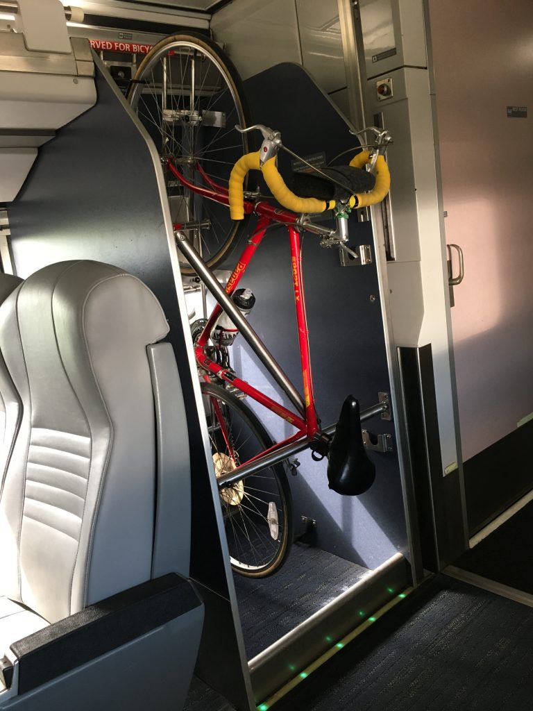
My journey started at the Albany-Rensselaer train station, where I finally got to try the roll-on bicycle storage service. I packed a week’s worth of supplies into my camping backpack, and climbed on board the train. Once I arrived in Rochester, it felt great to throw my backpack on, hop on my own bike, and get myself over to my host’s house for the week. No waiting for an Uber or walking to the Transit Center. I was very grateful to also make it to the Flower Pedal Populaire Sunday bike ride to kick off my week. It was great to catch up with so many people, and see how the city has grown over the past few years!
On-board bike storage on the Empire Service
My RTS Transit Ambassador schedule for the week was one for the early birds: 5:00am-1:00pm for Monday and Tuesday, then 6:00am-9:00am the remainder of the week. Reporting for 5:00am at the Hylan Drive Mobility Hub meant that I needed to plan my alarm time for the 45-minute bike ride to Henrietta with a little buffer time, and time to get out of bed and get ready for the day. 3:30am it was. My bike rides took me mostly on a straight line along Winton Road, which was eerily quiet at 4:00 in the morning.
The standard Ambassador uniform for the week was a blue RTS-branded apron, black RTS-branded mask, and a lime green RTS-branded visor. Hopefully it was clear that I wasn’t someone just loitering all day at the bus stop. Each Ambassador also received a small swag-bag with sunscreen (thank you!!), sanitizer, and information about the new bus lines and On Demand zones.
Showtime
Monday morning started quiet, dark, and empty at the Henrietta Transit Hub on Hylan Drive, where I was assigned. The Hub consists of two metal and plexiglass shelters facing each other across the street at the Wegmans driveway entrance. The shelters are enclosed on three sides, with the side that faces the street open except for a center plexiglass slat.
For being on a suburban arterial, it was incredibly quiet and peaceful watching the sunrise and listening to the hundreds of seagulls and geese making their morning rounds. As the way went on, though, the traffic and noise levels became dangerously high at times as cargo trucks zoomed by at 40 miles per hour no more than twenty feet away from my seat. I would honestly suggest flipping the shelters around and having the opening face away from the street. Keeping the noise and fumes out would create a much better ride experience.
My home base for the first half of the week
The first customer of the morning was a recent graduate from RIT, and an even bigger fan of transit than I was. He informed me as he walked up to the bus shelter at 5:50am that he wanted to be the first customer to try the new On Demand service. The On Demand hours begin at 6:00am, and at that hour two RTS-branded passenger vans drove up and staged at the far edge of the Wegmans parking lot. The customer boarded and went off to continue riding the new bus system for the day.
I was also happy to be joined by fellow Ambassadors across the street, and an RTS supervisor who was on duty for the day at the Hub to make sure things ran smoothly. As the morning progressed, I was extremely grateful that he was there and had direct access to dispatch communications, as I’ll explain.
Connection Hub-Bub
Many of us are used to having first-day jitters, bugs, and hitches with new programs and initiatives, and Reimagine was no exception. Being a completely new service, On Demand had a quiet start on Monday morning. Those who did try out the passenger vans sometimes found themselves waiting at the Hub long beyond their scheduled pickup time, but with no clear reason why. When someone called customer service, the representative found that they were indeed scheduled to be picked up at the Hylan Connection Hub at their specified time. But the On Demand vehicle was nowhere to be seen.
Luckily, RTS’s supervisor who was assisting us that day was able to speak directly with dispatch and the operators. It turned out that the location of the Connection Hub was incorrectly placed on the vans’ GPS units as being at the terminus of the bus routes (at Walmart on Clay Road), and not at the Hylan Drive shelters. So, operators were driving to Walmart when instructed to pick up a passenger at the Hylan Connection Hub. This was ironed out as the week went on.
Another change that was unexpected by some passengers was RTS Connect bypassing the Marketplace Mall entrance, which was where the fixed-route buses previously would pass through. The new routes were laid out to run directly down West Henrietta Road to Hylan Drive, without diverting into the mall property. While this was more efficient from a bus scheduling standpoint, the change proved to be less efficient for many passengers who were taking the bus to the mall. They now had to walk from the Hylan Drive Hub, and then halfway around the outside of the mall, to get inside. This feedback was passed along to operators who then updated the route by Tuesday morning to once again pass through the mall entrance.
Hopping Around Hubs
I offered my flexibility to the Ambassador supervisors during the week, and they took me up on the offer. Besides Henrietta, I helped to staff the Connection Hubs at Dewey Ave & Ridge Road, and Irondequoit Plaza. Each offered their own unique logistics that show just how diverse the neighborhoods around Rochester are.
On Wednesday and Thursday morning, Dewey Ave proved to be an important Connection Hub for commuters who work at the industrial centers on the west side of the city. This hub really served as a stress-test for the On Demand service, which had an On Demand zone comprised of all of the industry on the west side between Ridge Road and Lyell Ave. The flexibility of the On Demand service meant that pick up and drop-off times were not guaranteed, and it became apparent early in the week (before I was at that hub) that passengers would need to book additional “buffer” time for pick-ups and drop-offs to be on time for work. It was an evolving situation as the week went on.
Another piece of the puzzle involved the “long” and “short” fixed-route lines that served the Dewey Connection Hub. The long and short lines are basically overlapping bus lines, with one line running all the way to the far end of Dewey Ave at Northgate Plaza, and another stopping short at the Dewey Ave Connection Hub at Ridge Road.
Irondequoit Plaza was the quietest hub of the week in my opinion, mostly since I was stationed there on a Saturday morning. There were not any commuters to speak of in this bedroom neighborhood, and a smattering of early-morning Wegmans shoppers did alight from the fixed-route buses that terminated here. It was a good opportunity to chat with some of the bus operators as they laid over at the hub.
Finally, I ended my week on Sunday morning back where I began, at the Hylan Drive Connection Hub in Henrietta.
As I reflected on the week during the sunny and quiet Sunday morning, I was grateful to be on the ground to see how this system worked in the real world. As someone from a city so small that our buses only run once an hour, it was so much fun to get fully immersed in a city-wide bus system serving thousands of passengers a day. I’m looking forward to my next return visit, when I can be a full-time passenger on the RTS buses, and remember how vital our public transit is for a healthy and strong city.
Guest blog by Doug Kelley, Associate Professor at University of Rochester
I grew up doing a lot of hiking and backpacking in the woods of Alabama. Being outside connected me to a world that seemed more fundamental, more enduring, less corrupted by the mistakes of humankind. I felt empowered by the ethos of backpacking especially, that my own two feet could take me through the world from one beautiful place to another, and when I was gone, I would leave no trace, so others might enjoy the same beauty. I could forget daily stresses in favor of long conversations with friends, basking in sunshine and endorphins. I was (and am) a naturalist. I chose a college in the Appalachian mountains, and spent summers back in the Alabama woods, a counselor at Camp McDowell, quick to volunteer to lead kids on hikes.
Over time, my passion for being outdoors led to an idea that seemed surprising at first: for a naturalist like me, who wants to spend as much time outdoors as possible, the best place to live is not in the woods but in a densely-packed city center. Urban density allows me to live close to my workplace and commute by bike or public transportation, so I’m outdoors for an hour every day, routinely, without committing extra time. Urban density means there’s a small market a block from my house, a pharmacy two blocks beyond, a library within five blocks, a hardware store and supermarkets easily accessible by bike, and a huge number of restaurants, cafes, bars, and coffee shops nearby. In a city center, sidewalks and bike lanes and bus routes offer dense connections. When traveling to all these places and more, I can be outdoors, enjoying the same sunshine and exercise as on those Alabama trails, years ago.
Headed home from work on the River Trail, I enjoy fantastic views of downtown Rochester daily. (Credit: Doug Kelley)
Without urban density, neither I nor my neighbors — who I see often on sidewalks and porches — could benefit from so many amenities. If lots were bigger and residences weren’t arranged with as much density, our destinations would be pushed further away, often too far for walking or biking. In fact, many destinations would cease to exist. Markets and restaurants and shops are businesses that rely on having enough feet cross their threshold daily. Urban density puts customers close. Or, from the customers’ point of view, urban density puts businesses close.
A naturalist’s first instinct might be to live far outside the city center, near trails and hills and streams. Wistfully I can imagine myself stepping out of a house abutting Mendon Ponds Park, a favorite place to ski and hike and cycle, ready to start an outing without even getting in a car. But to gain that privilege, I would have to trade away countless hours of outdoor time enabled by my city life. Living by those trails, I’d be cooped up in a car every time I commuted, every time I needed groceries, every time I wanted a restaurant meal. RTS buses don’t go that far out. Altogether, that life would allow me far less time in the outdoors I love. Much better to drive to the trails and live in the city.
A favorite hiking destination at Camp McDowell was St. Christopher’s Pool, at the head of a canyon and beneath a waterfall near the edge of the property. But in those years, St. Chris’s was badly defaced, its rocks and water turned a sickly shade of orange by runoff from the coal mine upstream. The Rev. Mark Johnston, executive director of Camp, waged a legal battle that ultimately brought the mine’s owners to remediate the stream, largely restoring St. Christopher’s. Mark also reminded campers and staff often that though the mine owners were culpable for property damage, all people are responsible for being good stewards of shared resources, and we ourselves contributed to the damage when we used the electricity produced by that coal. It was a tough lesson, and an important one.
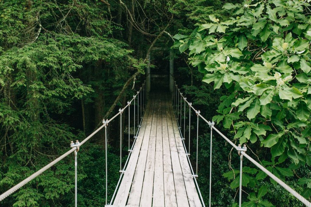
The swing bridge (left) that campers cross to get to the beautiful St. Christopher’s pool (right). (Credit: Camp McDowell & Joe Pradat.)
That lesson, too, leads naturalists to value urban density — because it seriously reduces our own contributions to the human damage of natural places. New York City has the highest population density of any large area in the United States, with 27,000 residents per square mile. New York City also has a vastly smaller per-capita carbon footprint than typical American places: in 2015, an average resident produced emissions equivalent to 6.1 metric tons of carbon dioxide, less than a third of the national average of 19. Likewise, an average New York City resident uses far less energy and produces far less waste than an average American. It’s no coincidence that urban density reduces carbon footprints, energy use, and waste. Density enables car-free transportation, which burns little or no fossil fuel. Density also makes residences more efficient, because apartments are insulated by their neighbors, and because smaller residences almost always require less heating and cooling. And as anybody who’s cleaned out their garage knows, having more space inevitably leads to accumulation of more stuff — not all useful!
Reflecting more deeply, the lesson of stewardship and the naturalist’s leave-no-trace ethos are fundamentally about equity, and urban density promotes equity, too. Beyond leaving natural places untrammelled and less-damaged by climate change, density makes healthy and pleasant lifestyles available to all, even those who never spend time in the woods, either for lack of interest or for lack of opportunity. Regardless of social and economic status, almost everybody can walk and bike, which opens a myriad of possibilities in a well-designed city center. Public transportation is more broadly affordable than personal automobile ownership. And density matters even more for people with disabilities, for whom nearby amenities are no mere matter of convenience.
Obviously, Rochester is not as dense as New York City, but at 6100 residents per square mile, its density exceeds many American cities, including Austin, TX (3200), Cleveland, OH (5100), and even the famously bike-friendly Portland, OR (4800). Most of Rochester proper and some suburbs boast sidewalks and gridded streets, making walking and biking easier and more enjoyable. Gems like the Canal Path and River Trail connect pedestrians and cyclists to more amenities over greater distances. Regional bike infrastructure is being steadily improved and expanded. Many neighborhoods in our region are great places for the urban naturalist lifestyle.
Some of Rochester’s density was automatic, because the city predates personal automobiles. But now, building and maintaining people-friendly city centers requires conscious choices, good policies, and ongoing input from citizen-naturalists. Reconnect Rochester has made major efforts to encourage urban density and make outdoor city life more pleasant and equitable. The work continues, and you can help. For starters, Rochester’s zoning laws have put limits on density, but are now being reviewed for revision, so leave a comment supporting urban density. Urge leaders to implement and expand bike master plans. Nearly every local municipality has one, thanks largely to the Rochester Cycling Alliance (for example, see the City of Rochester plan). Or get involved with Complete Streets Makeover for hands-on projects making outdoor urban spaces more practical and beautiful. Get plugged in to Reconnect Rochester’s work so you can learn about opportunities to volunteer for hands-on projects, attend public meetings, sign petitions, and be part of the effort.
The tulip trees on Oxford Street are among the many everyday delights of my bike commute, made possible by urban density. (Credit: Doug Kelley)
In the end, my bike commute may not have the same grandeur as summiting one of the Adirondack High Peaks, but doing it every day makes it more important to my life, health, and peace of mind. On the River Trail in the morning, I see groundhogs and rabbits frequently, and also deer, turkeys, hawks, and occasionally a fox or heron. In the afternoon, I enjoy a grand river vista of the Freddie-Sue Bridge with downtown buildings towering beyond. For one precious week every spring, I revel in an explosion of color when the Oxford Street tulip trees bloom. And knowing that urban density not only helps me enjoy the outdoors, but also helps me leave no trace and allows many others the same benefits — that makes these natural experiences sweeter still.
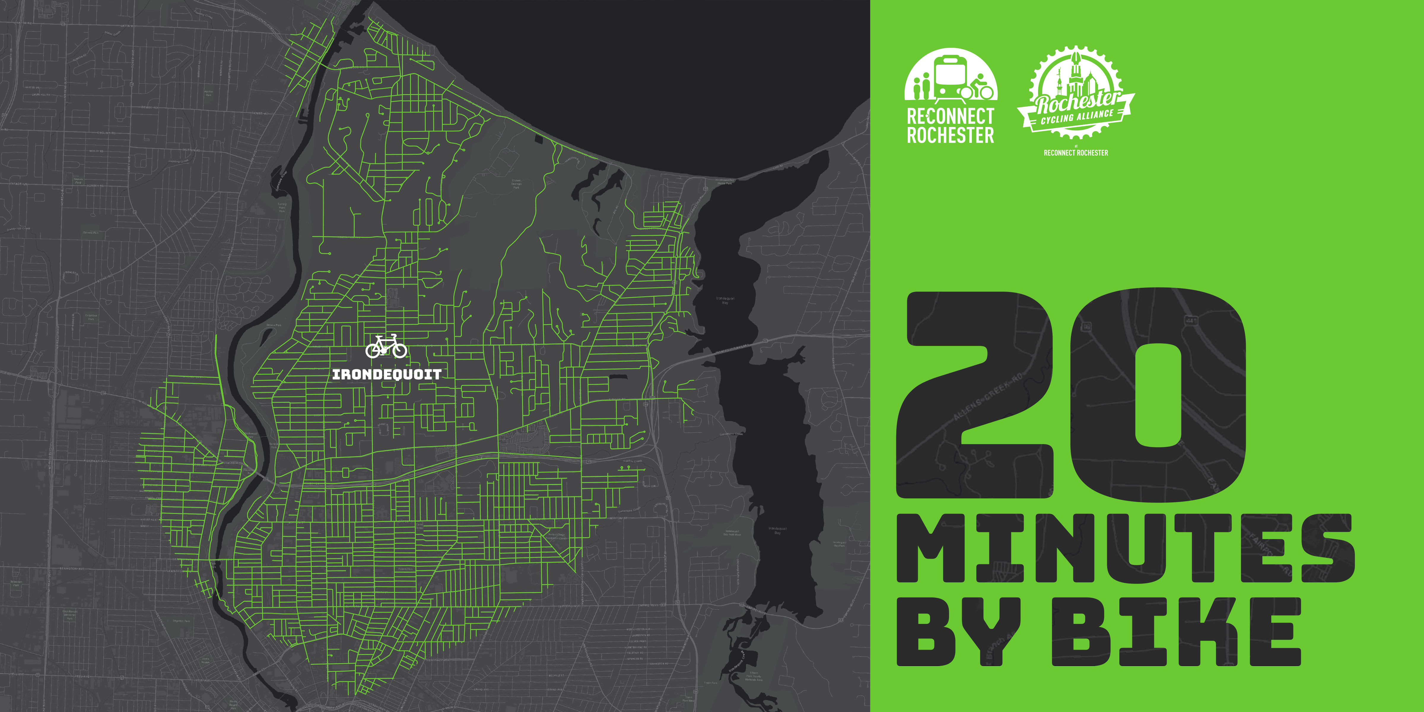
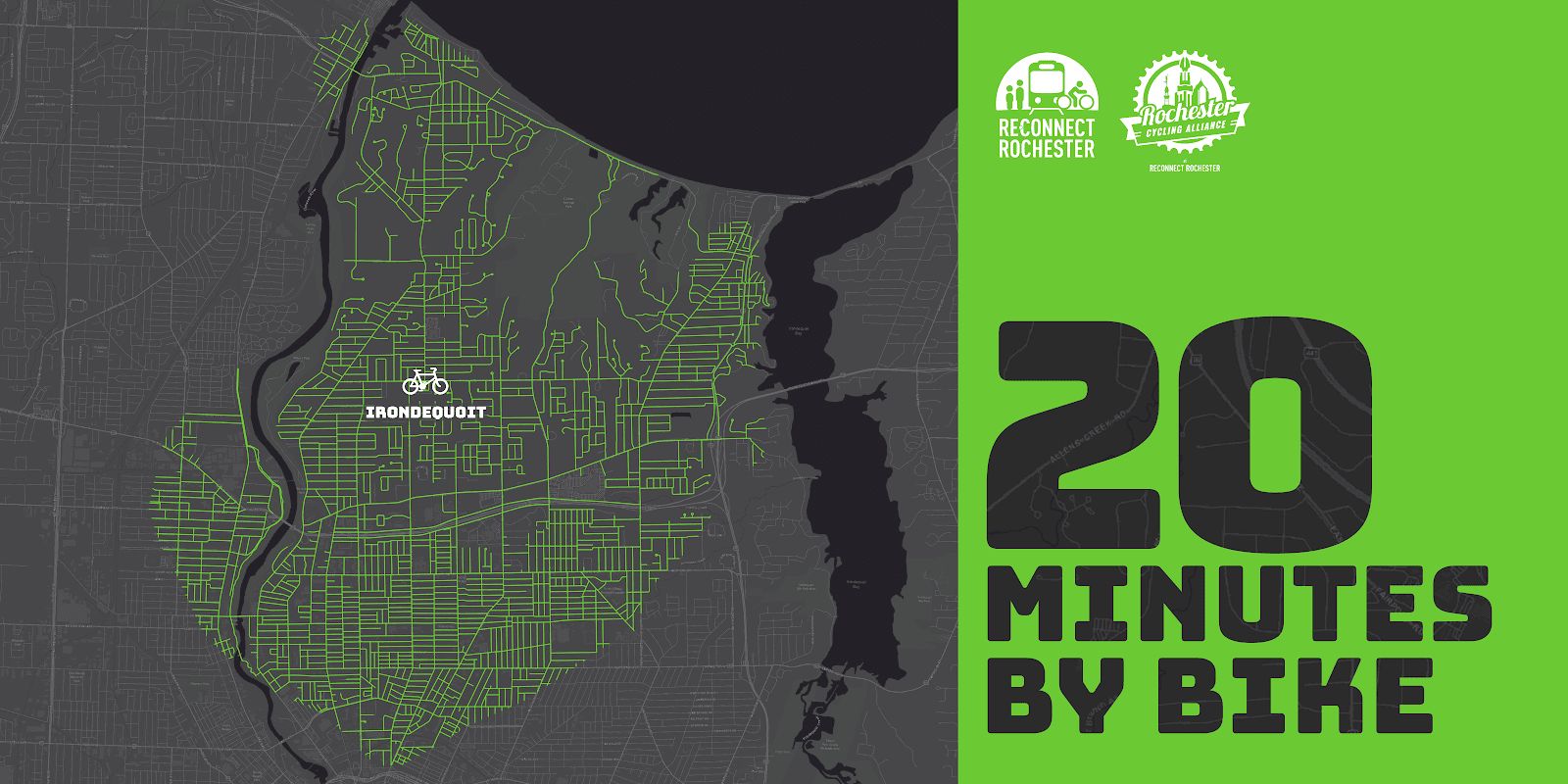
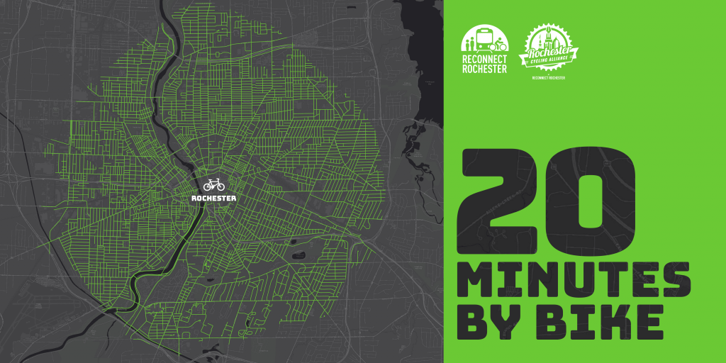
The Rochester area is famous for its 20-minute commute. For driving that is. Reconnect Rochester and the Rochester Cycling Alliance are excited to ask a different question in this blog series: Where can you get within 20 minutes on a bike?
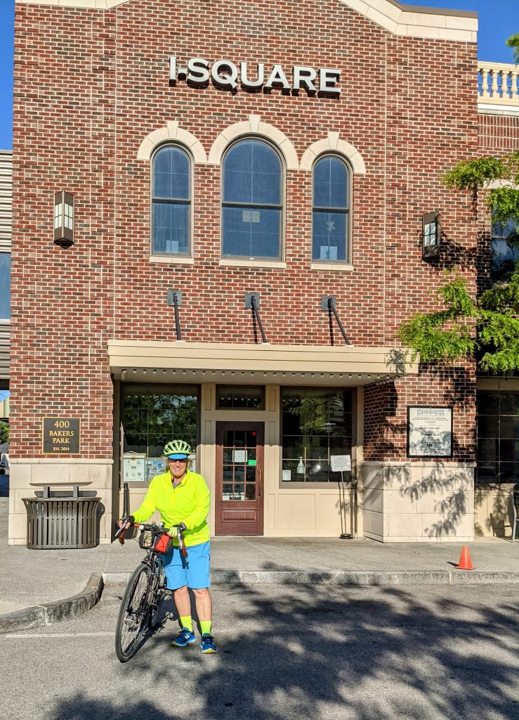
Presenting the second in a series of custom “bike shed maps.” For this next installment, we chose Irondequoit’s “central square” – I-Square – and are showing how far out in every direction you can get on a bike at a casual but steady pace of 10 miles per hour. This means that if you live anywhere in this green area, you can get to I-Square within 20ish minutes on a bike. Thanks again to Brendan Ryan and Mike Governale for their help putting these maps together for us.
To get us familiar with this green territory in Irondequoit, here’s Pam Rogers sharing her personal travel-by-bike experiences.
Introduction
I’m so excited to share with you my personal recommendations for cycling in my favorite area of Rochester, which also happens to be my local neighborhood! Forgive me if it turns out to be an homage to Irondequoit, but it’s my way of letting you know all the best reasons to find yourself cycling here.
If you’re looking for places to ride, no matter what kind of cycling you enjoy, you’ll find something to love here in Irondequoit. It’s full of hills and flats, roads and trails, natural beauty, local history, family fun, and great places to stop and rest for food and drink. Whatever you’re looking for, it can be found between the shores of the Genesee River, Lake Ontario, and Irondequoit Bay!
How To Ride Here
The best route into town are as follows:
From the Northwest – the LOSP trail that follows along the parkway is the best, and it drops you out right by Pattonwood Dr and will take you over the river and into Irondequoit.
From the Southwest city environs – come on up St Paul St and then hop on the El Camino Trail that begins at Scrantom St and takes you north all the way up to Navarre Rd and across from the Zoo entrance – you’ll love the old railroad bridge that takes you over 104 without worry
From the Northeast – Well, when the swing bridge is available it’s easy peasy, but when it’s not you’ll need to approach from the south of the Bay and come around by way of Empire Blvd. Yes, busy with traffic and a very challenging hill to climb – bail out as soon as you can, on Orchard Park Blvd, if you don’t mind a few more hills to climb with a bay view, and then follow Bay Shore Blvd to get you to Ridge Rd and turn right at Kane Dr before it ever gets busy, that will take you right up to Sea Breeze Dr!
From the Southeast – The only way to get over the 104 expressway is to take Culver Rd but there are plenty of side streets to stay on south of it, and just north you can turn right on Brower Rd and cut through the neighborhood to come out on Ridge at Walnut Park, then quick jog over to Kane Dr to get to Sea Breeze Dr.
All Roads Lead To/From I-Square!
If you live in Irondequoit, you know our town’s “central square” is now I-Square. It was developed with a vision, to not only improve quality of life for town residents, but also to be a role model for green, environmentally responsible and energy efficient building projects. It’s a destination unto itself with restaurants, rooftop gardens and dining, outdoor amphitheatre, the Imaginarium, Art Gallery and Science Center.
From here, it will take you less than 20 minutes to ride in any direction and find our other local treasures. West to the zoo and the river, north to the lake, east to the bay, and all wonderful tree-lined neighborhood streets along the way. When riding in town, and you must cross busy intersections, it’s safest to pick the crossroads with lights. For example, riding in northern neighborhoods divided by Hudson Ave, you can cross safely at the light using Brookview Dr to Diane Park.
You can find steep hills, nice flats, and occasional rollers. You’ll find most of the steep hills along the shores of Irondequoit Bay. There are serene and quiet neighborhoods tucked away in all corners of town: check out Rock Beach Rd off Lakeshore Blvd in the North, follow Winona off St Paul Blvd, or discover Huntington Hills nestled up against Durand Eastman Park by taking Pine Valley Rd to Wisner, and be sure to take a fun ride down Hoffman Rd behind the Irondequoit Cemetery to the end where it stops at a trail you can take through the Durand Eastman Golf Course. There, you’ll find an old hidden road overgrown with weeds that you can ride from Kings Hwy N, where Horseshoe Rd stops being a maintained road, and you can ride it along the northern edge of the golf course, across the creek, and back up to Lakeshore Blvd.
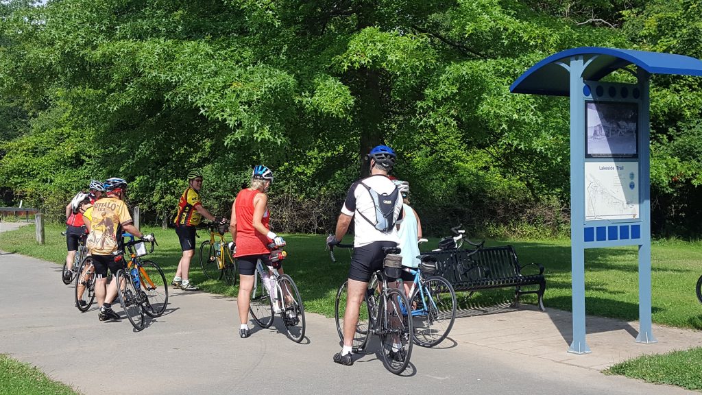
There are off road trails to explore as well. You can follow a dirt/stone trail along the east side of the river from Seneca Park Zoo all the way to the lake, which follows the old Windsor Beach Railroad line started in 1883 that traveled from the city’s Avenue E all the way north to Summerville. You can ride challenging single track trails along the west part of the bay in either Tryon Park or Irondequoit Bay Park West. Don’t forget the nicely paved pathways too! There’s one along the shore of Lake Ontario from the corner of Culver and Sweet Fern (right next to Parkside Diner) and extending to just across from Camp Eastman on the lake shore. The other one is Sea Breeze Dr along the northern section of 590 from Titus down to Culver Rd and Sea Breeze.
Nature/Water/Parks
You may not know this, but Irondequoit, by its very name of Iroquois origin, means “where the land meets the water.” And there’s just nothing like being close to water and natural spaces, is there? The views are beautiful and varied. Some of my personal favorites I’ve already mentioned, and there are smaller parks dotting all the neighborhoods for kids to enjoy too. A completely hidden gem is Densmore Creek Falls, accessible from the back parking lot of the Legacy at Cranberry Landing at the very eastern end of Norton before it crosses over 590 and drops down by the bay.
Food & Drink
I-Square has plenty of options for food and drink, and beautiful outdoor seating on the roof as well, so if you’re in the neighborhood you can cycle on over and enjoy! Right around I-Square you will also find the Cooper Deli, Titus Tavern and the Irondequoit Beer Company. At the very northern end of Clinton Ave there’s a little-known but exceptionally unique eating experience that awaits you called Atlas Eats, and it’s the best for a weekend breakfast. Another hidden treasure for you ice cream lovers would be Netsins Ice Cream Shop on Culver Parkway.
If you love to ride farther afield, and take a break from your spinning wheels along the way, our waterfront taverns abound. I love to make routes that include these special stops in the neighborhood for that. Summerville has Silk O’Loughlin’s (Olie’s). Sea Breeze has Marge’s Lakeside Inn (sit on the beach!), Bill Gray’s, Shamrock Jack’s Irish Pub, and Union Tavern (it’s haunted!). There’s Murph’s Irondequoit Pub, a neighborhood staple, now down by the O’Rorke bridge, and across the way take Marina Dr down to the end and you’ll find Schooner’s Riverside Pub, an open air only open in the summer fun kind of place.
Family Fun
You could plan a day of cycling with the kids in the small neighborhoods in Sea Breeze, stop by Parkside Diner, play a round of mini-golf next door at Whispering Pines, then head down to the Sea Breeze Pier and Beach. Need I say, Sea Breeze Amusement Park? Or ride the little neighborhoods off St. Paul Blvd. around Winona, and at its southernmost tip, take the sidewalk connecting to Maplehurst Rd, turn right and there’s paved access directly into the Seneca Park Zoo.
Routes You Might Enjoy
Feel free to use these as a starting point to create your own adventure!
by Jesse Peers, Cycling Coordinator at Reconnect Rochester
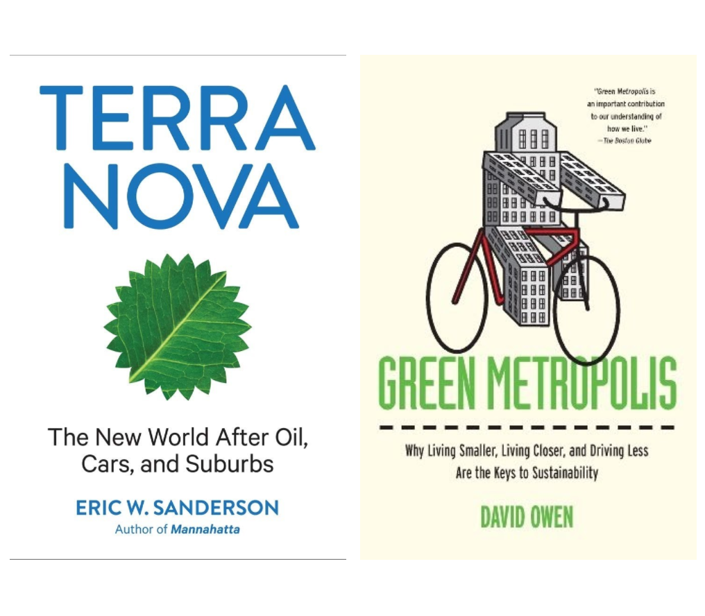
In past blogs, I’ve mentioned how Reconnect Rochester’s ROC Transit Day inspired me to try getting to work on a bike for the first time. I’m so grateful to Reconnect for providing that initial inspiration. I owe further credit to Howard Decker’s blog which introduced me to Eric Sanderson’s book, Terra Nova: The New World After Oil, Cars, and Suburbs. If ROC Transit Day got me on a bike for the first time as an adult, Terra Nova kept me on my bike.When the only car I’ve ever had bit the dust while reading this book, I was so inspired by what I was reading that I donated my car to charity and haven’t had a car since.
I’m a bookworm concerned with climate change and on occasion I tackle thick, scholarly books. Maybe due to its length, Terra Nova isn’t for everybody, but to this day it’s the best non-fiction book I’ve ever read. I highly recommend it! In 2015 I was pleased to discover a great companion piece to Terra Nova: David Owen’s Green Metropolis, a very similar book which is shorter and more readable for most people. Together, these two books examine what got us into this climate mess and how we can get out of it. When one learns about our climate crisis, it’s easy to get discouraged. These books however offer a doable approach that leaves you feeling hopeful and encouraged. We can do this.
Lessons Learned
What both authors make clear is that a cleaner, sustainable future requires an investment and turnaround in three areas of life: energy, land use and transportation (and more generally, our habits). One can pay quite a bit of attention to the climate movement and really only hear about energy, as if all we need is a simple 1:1 substitution between gasmobiles and electric vehicles (EVs); between natural gas and solar. But it’s not that simple. As Evan Lowenstein of The Climate Accelerator points out in this recent blog, tech alone likeEVs and solar won’t solve our problem. Part of that is due to energy load: “A million drivers plugging in their cars when they get home from work…would strain the power grid.” We’re simply not ready for that. Besides, fuel efficiency just incentivizes driving more. And we don’t need more traffic and traffic deaths. Status quo car-dependency and the enormous health and financial costs that go with it aren’t the way forward.
The other reason is because as Owen states, “the power we don’t use is more important than the power we do.” Take hot summer days for instance. Nowadays when we’re hot, “we adjust the thermostat rather than identifying the source of the problem and looking for a low-tech remedy.” Let’s instead do “what our parents and grandparents did: opening windows at night, to cool the entire house, then shutting the windows in the morning and drawing the curtains in the sunny rooms, to keep them from rapidly heating up again.” I’ve found that this works on all but the hottest Rochester days. In the same vein, the transportation power we don’t use is more important than what powers our vehicles.
“The transportation power we don’t use is more important than what powers our vehicles.”
Similarly, “we must significantly reduce the number of miles we drive, not merely replace one motor fuel with another one.” As Owen reminds us, “the main job of any car is moving the car itself.” Driving is the least energy-efficient way of getting around and society must start discouraging single-occupancy car trips by making it costlier and less pleasant (and by making the alternatives faster, reliable and more pleasant). We respond to incentives and disincentives. “In the long run, miles matter more than miles per gallon. A car’s fuel gauge is far less significant, environmentally speaking, than its odometer.”
Perhaps your workplace is too far away to walk, bike or take a bus to. Okay, you’ve gotta drive. But what other regular destinations are near your home? (The grocery store, library, pub, kids’ school, etc.) Sanderson estimates that most people are willing to walk to destinations within a half-mile, bike or scoot up to 2.5 or 3 miles, and take transit to destinations within 5 miles. That’s a great place to start! Reconnect Rochester’s 20 Minutes by Bike map shows where you can get to from downtown Rochester in 20 minutes riding at a casual pace. (Stay tuned to our blog for more area maps to come!)
We must also “contract the distances between the places where people live, work, shop, and play.” This is where land use comes in. Mixed-used development and zoning changes are crucial. This does mean reimagining the suburbs a bit. Both authors make clear that the suburbs as we have known them in terms of car-dependency, can’t last. The societal and environmental costs are too great.
Finally, we’ve gotta deal with our overconsumption. “The average American single-family house doubled in size in the second half of the twentieth century” as family sizes plummeted! Rather than move every seven years to an ever-larger house farther away (only to fill it with more stuff and become even more car dependent), we would do well to develop a philosophy and “economy of enough” as climate activist Naomi Klein notes. Check out Rochester’s old trolley neighborhoods, where most lots don’t have original garages since residents used to walk to the end of the street and take a trolley every morning. Because today’s bus routes still more or less follow those old trolley lines, these neighborhoods have pretty reliable transit.
The graphs & illustrations in Sanderson’s book are superb!
As you can see, whether it’s resisting the temptation to blast your AC all the time, biking to a destination, or choosing to live closer to work (Rochester remains one of the most affordable communities in the country to live car-free), Americans will have to change habits to meet the climate crisis. We’ve gotta go beyond focusing on what powers our stuff and reexamine how we settle and how we move. It’s important to note many of these lifestyle changes aren’t sexy. Rather than being high-tech and Jetsons-esque, many solutions to the climate crisis are old-school and therefore sustainable footprints and everyday life will look much like how our great great grandparents lived: That’s a good life!
Watch Saga City for more on the crucial role of land use and transportation in building a sustainable future.
Remember when you learned how to drive? You learned about the blind spots to the left and right of your vehicle, those spots where another car might be, hidden even from all your mirrors. That there might be things there you aren’t seeing.
There’s another blind spot putting us at risk here in car-centric America: the one that prevents us from thinking beyond the automobile as we strive for climate solutions and a truly sustainable society.
The rise in concern about climate change in society and industry is encouraging, and happening not a second too soon. But the well-intentioned efforts run the risk of falling way short because of our perilously persistent belief that we can achieve a climate-safe, sustainable future simply by running our cars on something besides fossil fuels.
Transportation accounts for 40% of our climate-changing greenhouse gas emissions, and converting vehicles from fossil-fuels to more cleanly-generated electricity surely can reduce those vehicles’ emissions. But the way they are fueled is just one of many environmental, economic, and equity problems caused by our cars — and just one of the problems inherent in our prevailing transportation model and mindset.
Thus, there is an inconvenient truth hidden in our blind spot: as we seek transportation modes and systems that are better for the environment, for the economy, and for equity, electric vehicles are the next-worst option to the fossil-fueled ones.
Why Electric Vehicles Aren’t Enough
The switch to electric cars as a solution to climate change depends simultaneously on a massive transition to renewable energy, such as wind and solar, happening at an unprecedented speed. If we don’t transition to renewables as fast as we transition to electric cars, electric vehicles won’t produce any real progress on climate change. The switch also means a massive increase in demand on our already-strained electric grid; in addition to the cost of putting up that much renewable energy, we then have to upgrade the grid to carry it all.
And electric cars are still cars — machines that produce environmental impacts such as water pollution from tire and brake residues, and leaks of toxic materials from millions upon millions of compromised vehicles; pollution from extraction of materials needed and energy needed to make them; gargantuan fossil-fuel expenditures needed to transport them from manufacturer to individual buyer. In addition, the massive road and storage infrastructure (parking lots) needed to accommodate individual cars as a primary transport choice has titanic environmental impact: polluted runoff, biodiversity loss and roadkill from fractured habitat, etc. Having to maintain all this outsized, inefficient infrastructure forever also creates enormous financial challenges for governments, and prevents resources from being used more wisely.
The Cost of Personal Vehicles
Speaking of roadkill — cars also kill a lot of people too, upwards of 60,000 annually in our country from crashes and illness from fossil-fueled air pollution. And many people killed by cars are low-income and people of color, forced into walking or cycling in car-centric communities without adequate provisions for pedestrians or cyclists; and/or forced into living in places with the worst auto-borne air pollution.
Car-culture also creates and perpetuates more inequity like this. Cars are already expensive to own, maintain, insure, and fuel. Low-income people without the means to own cars are shut out from many needs and opportunities (jobs, education, recreation, culture) that are accessible only by car. In addition, most low-income people rent instead of own their housing, and even if they were able to access electric vehicles, they likely wouldn’t have easy access to charging. If the shift to electric vehicles makes car ownership even more out of reach for low-income people, the equity gap exacerbated by car-culture will grow even wider.
Building a Multi-Modal Future
We must start seeing what’s in the blind spot–the fact that a switch from gas-powered to electric vehicles cannot be the primary push as we strive for sustainability. Instead, we must understand that the best car trip for climate and sustainability is not an electricity-powered car trip, but the absence of a car trip.
Then, we must focus our planning and funding to make it easier for more people to transport themselves by bus, rail, bicycle, and foot. Note that an electric bus or train uses ten to twenty times less electricity per passenger mile than an electric car does — no matter how clean or dirty the electricity supply is, they are always that much better. And even if buses and trains aren’t electrified, they produce less overall impact than electric private vehicles as a whole, simply by transporting more people over less distance. Walking and bicycling for transportation — if done safely using adequate infrastructure provided for it — produces positive health benefits along with the environmental benefits.
Seeing what’s in the blind spot also means developing land and our communities more efficiently so that transit, bike, and pedestrian transportation modes are viable for a lot more people. Community design with this location efficiency in mind will also save energy, land, and natural resources, meaning that planning for car-free lives enables climate solutions well beyond the transportation modes themselves. This location efficiency also makes it more feasible for car sharing and carpooling — putting more people in each car is a super-sensible and affordable climate solution as well.
The hard truth is that climate solutions, sustainability, and equity cannot be achieved solely through intention, but rather through execution. And executing requires plugging all the key facts into our designs of policy and place. We cannot let this big blind spot — an overemphasis on electric cars — run us off the road to our destination: a cool, carbon neutral planet.
I saw something today that blew my mind. The average new road vehicle retails for $37,876. Can we say that again? Americans are purchasing cars, trucks and SUVs to the tune of $38,000. In a time when we are asking questions of equity and “pay-to-play” constructs in our American culture, is there anything more exclusive than the automobile?
Most of our focus in life revolves around three basic things… our home, our work and how we connect the two. After World War II, the Federal Government subsidized the construction and purchase of homes outside of city limits in areas now referred to as “the suburbs.” But that wasn’t enough… with major employers still entrenched in urban cores as a matter of practical business, the same administrations facilitated the creation of automobile expressways that allowed white Americans, who could afford cars to access jobs while living in racially exclusive suburbs, to commute efficiently to their employment epicenters. And as no surprise, these highways doubled as a way of demolishing “blighted” black neighborhoods, segregating white from black, and rich from poor in our cities.
Redlining and racial property covenants (among a host of other elements of institutionalized racism) ensured that people of color could not transcend their circumstance, creating an un-traversable economic fissure between wealthy white and struggling black citizens in highly polarized and segregated counties.
Car, oil and rubber companies furthered the plight of inner city America by lobbying for wider roads, campaigning for “jay-walking” to become a public offense and famously purchasing the private city street car companies, only to immediately disband them. All this to ensure that the most expensive and exclusive mode of transportation was virtually the only mode of transportation. And of course, this was all done to the tune of billions of dollars in subsidies for auto-related manufacturers and the building of automobile infrastructure that a huge percentage of the country simply could not afford.
How do you disenfranchise an entire group of people? Simple. Tell them they can only live in one place, (which we as a country did) then incentivize everyone else (and thus American jobs) to move away from that place… and for the final touch, make it too expensive for the disenfranchised population to access good jobs, public resources and any hope of upward mobility. The perfect purposeful recipe for racial, cultural, economic and social isolation.
Let’s go back to the cost of the average new vehicle, $37,876. The average Black household in the U.S. earns $41,511 (2018), less than $4,000 more than the cost of the average American automobile.
Can Americans purchase a used car for much cheaper? Absolutely. But a huge percentage of disenfranchised communities still struggle with high interest rates and all the “extras” that go along with car ownership (insurance, fuel, maintenance, registration fees, etc.). When the process of conveniently commuting requires 40% of your income, something is seriously wrong.
“The financial burden that the car-centric American narrative places on our families is stifling. … Those who can purchase and maintain a car win…everyone else loses.“
As someone who purchased a used car 6 years ago for $7,500 and still occasionally uses that car today, I am in absolute awe of the amount of money my friends spend on cars, trucks and SUVs that I would consider “luxurious.” The financial burden that the car-centric American narrative places on our families is stifling. The amount that middle class American families are willing to spend for the convenience of two SUVs is staggering. But the myth that this choice is a necessity is one of the most racially and socially exclusive economic and psychological constructs in American culture. I would argue that the toxic level of “pay to play” exclusivity in this country is and always has been the veiled mirage of the automobile as the only means of convenient transportation. Those who can purchase and maintain a car win… everyone else loses.
When the average cars costs $38,000, equity is not possible. When the average commute of 23 minutes by car is an hour and twenty minutes by bus, equity is not possible. In a nation where Black Americans were disallowed to thrive in our urban cores, this same social and economic rift occurs today with regard to transportation and the convenient access of jobs and services.
Redlining derailed black neighborhoods by placing a financial ceiling on their communities. Property covenants and other restrictions disallowed people of color from moving to other neighborhoods. The war on drugs targeted black males in a conscious effort to disrupt black families. Today, in a world where mobility is such a strong determinant for success, the century-long subsidization of the most expensive and exclusive form of transportation continues to add yet another wrinkle in the fabric of blatantly racist agendas that our country has supported.
“Want to make the United States more equitable? Support public transit that serves everyone.”
It’s time to realize that the American automobile, and the immense infrastructure that facilitates its transportation dominance, might be one of the most toxically racial tools this country has ever seen. Want to make the United States more equitable? Support public transit that serves everyone. Support walkability and infrastructure projects that limit automobile speed and prioritize pedestrians, especially in traditionally minority-based neighborhoods. Support urban density that considers the needs and desires of Black Americans. The American car/truck/SUV has pummeled the core of U.S. urban density… let’s realize this as a mistake and get aggressive about building a more equitable future of mobility in our urban centers!
A few related notes and resources from Reconnect Rochester. . .
We appreciate this excellent piece by Arian at The Urban Phoenix that makes new and insightful connections between mobility and racial & economic justice.
Over the past five years, Reconnect Rochester has been part of an effort to examine the relationship between transportation and poverty in our community, to better understand the problem so we can identify possible solutions, and act on them. Resources this effort has generated can be found here on Reconnect’s website and include:
A 30 minute locally produced documentary film that focuses on the lives of three Rochesterians to give us a firsthand look at what life is like when you can barely afford to buy a bus pass, much less a car.
Our efforts continue through the Rochester-Monroe Anti-Poverty Initiative (RMAPI)’s transportation work group. In collaboration with many community partners around the table, we work to translate the report learnings into systemic policy recommendations and actions that can create real change.
by Arian Horbovetz, Reconnect Rochester Board Member and author of The Urban Phoenix blog
If you’re like me, a firm believer that public transit, walkability and bike Infrastructure can make our city better, the last few months have been grueling. Empty buses, the encouragement of single-passenger automobile ridership, and the loss of Zagster’s Pace bike share here in Rochester have us all wondering about the future of multi-dimensional mobility in our city.
Zagster’s abrupt departure from Rochester’s landscape earlier this year was a shock to many who believed that bike share made The Flower City a better place. The freedom of grabbing a couple bikes while enjoying an evening downtown, or filling the last mile gap on your daily commute is suddenly absent.
The hope had been that 2020 would bring a fresh new season of bike share, and possibly scooter share to the Rochester transportation network, but the pandemic that is upon us had other plans. Shortly after it was announced that the start of the Pace bike share season would be delayed, Zagster abruptly pulled the plug on the program altogether, stating that the company was “reassessing its business model.” While Rochester actively searches for a new bike share vendor, here are some key points to understand about the Zagster/Pace departure.
It’s Not Our Fault
Zagster is a venture capital company, which is a business model that can quickly rocket a good idea to soaring heights. The downside is an increased level of volatility, which can lead to these kinds of aforementioned “reassessments,” or even closures without warning. The unprecedented impact of the COVID-19 crisis has caused a massive ripple in our nation’s economy, one that has caused every business to make drastic changes and hard decisions. This was noted as a key reason for Zagster’s departure from Rochester, as well as ceasing operations in other mid-sized cities like Norfolk, VA. On May 27, Zagster formally announced its closure as a company.
Rochester’s Ridership Was Remarkable
Over the past three years, Pace bikes settled into our local culture as an easy, convenient way to get around. Over 22,000 Rochester residents activated accounts over the three years Zagster was operating in our city, and those customers took a remarkable 116,951 trips.
At Zagster’s end-of-season report in November 2019, it was reported that “Pace Rochester continues to be Zagster’s most utilized bike share fleet in the country, with 189 trips taken daily!” Rochester riders totaled more than 40,000 trips in 2019 alone. Company representatives often described Rochester as Zagster’s “flagship” mid-sized city for our ridership numbers.
An end of year user survey in 2019 revealed that “half of all trips replaced the use of a personal or shared vehicle,” highlighting just how important the service was to the transportation landscape in the City of Rochester. And ridership mapping suggests that many Rochesterians heavily used the bike share to get to suburban job locations, like Marketplace Mall in Henrietta.
Bike Share Theft Happens Everywhere
Midway through the 2019 season, empty bike racks and “ghost bikes” (bikes that appeared on the Pace App but were not physically present) revealed a rash of rampant bicycle theft. Nearly two-thirds of Pace’s Rochester fleet was stolen, leading to a sea of bad press and public doubt.
While the stories of significant theft, followed by Zagster’s subsequent departure caused many Rochester residents to believe the two were related, it’s important to remember that bike share theft happens everywhere. Wherever there is something of public value, there will always be a select few in any community who will try to pilfer it. While the theft of Pace bikes in Rochester was difficult, it was not at all uncommon. The onus is on the bike share provider to anticipate this construct and design their equipment with safeguards. But the lack of a GPS tracking device on Pace bikes made solving the problem through recovery and prosecution of theft nearly impossible. The next vendor will need to have more anti-theft technology built into their bikes.
We Will Have Bike Share Again
Fear not… Rochester will have bike share again. And very likely, e-bikes and e-scooters will be added to the menu. The City Of Rochester is actively searching for a new operator with which to partner, and word on the street is that we may see a limited launch for a few months this fall, and a fully operational system in place by spring 2021.
This Is Not Another Fast Ferry
While we may fall victim to the Fast Ferry narrative of “this is why we can’t have nice things,” we must realize that the challenges that walk hand in hand with bike share are not unique to our city. Zagster’s departure should not be seen as a failure to retain a valued resource, but rather a chance to connect with a new brand that is better equipped to handle the nuances of bike share in mid-sized cities. So before we internalize the loss of Pace bike share as a Flower City Failure, let’s remember the big picture that was three years of successful bike share utilization in our city.
We know one thing for sure… Rochester’s stint with Zagster showed us all how vital a role bike share plays in the transportation fabric of the city. While also serving as a tremendous recreational draw, bike share’s ability to connect residents and visitors to work, home, destinations and other modes of transit makes it a powerful piece of transportation infrastructure for Rochester.
I have found that during this pandemic, there have been times when I really don’t want to do much of anything. In the morning, I roll out of bed to my bedside table which I have made into my makeshift work desk. I spend most of the work day locked in my bedroom to create a private and HIPPA compliant space so I can talk to my clients who have SPMI (Severe and Persistent Mental Illness). There are days when the emotional toll of my work day is hard to leave behind. Social media and those fighting back against what the experts have to say have made tuning everything out all the more difficult.
I’ve found the cure to cabin fever, a cure I have known all along but sometimes it takes reminding, is riding my bike. Whether it’s riding by a friends house as they’re sitting out on their porch, or heading to the local 7-11 or liquor store to get a beverage for dinner that night, those quick trips make all the difference in my day.
I’m not suggesting you ride 25 miles down to Avon on the Genesee Valley Trail, or ride from Buffalo to Albany on the Erie Canal. I am writing this as a gift to you, to dust off your bike and take it for a ride down the street. Whether you have the intention to swing by a friend’s house to say hi and pick up tomato plants, or to the 7-11 to pick up a six pack of beer, I promise the satisfaction of giving yourself some fresh air while doing something practical and time enhancing will make all the difference in your life.
Your bike does not, and I repeat, DOES NOT have to be in the most perfect shape. Make sure you can come to a complete stop at a stop sign and make sure you’ve got a little air in those tires. If you do not own a bike, lots of folks in our community are selling great ones on Facebook Marketplace. Ask questions and look for something you like.
Decrease your excuses to increase your joy. I hope our music video will encourage you to get on that bicycle and ride!
Guest blog by Doug Kelley, Associate Professor, University of Rochester.
In my first few long bike rides this spring, I’ve been bowled over by the beautiful views. And it’s not like I’m visiting new places. I pedaled these same routes last summer, when I first came to Copenhagen for a yearlong sabbatical and was eager to explore. But never were the vistas like this! Now, the hills and buildings of Sweden, 10 miles across the waters of Øresund, are not just blurry shapes, but clear and distinct and colorful. Now, looking southwest from the gorgeous seaside bike path in Naturpark Amager, I can see the towns of Køge and Strøby across the bay, nearly 20 miles distant and never visible before. First noticing these fantastic vistas, I gave thanks for the end of the dark and rainy Danish winter. Then I remembered that visibility was never this good last August or September. Something else must be happening. That something is probably covid-19.
The coast of Sweden, bright and clearly visible across Øresund from a marina north of Copenhagen. Clearer air, improved respiratory health, and lower carbon emissions all come when motor traffic is reduced, as the pandemic is showing us.
The pandemic is causing profound suffering worldwide, through death and sickness, through separation and hardship. I would not wish it upon anyone. The pandemic is also giving humankind a unique opportunity to see — firsthand — what our lives look like when motor traffic is significantly reduced. Few are driving, which means less air pollution, and we can see the improvement with our own eyes. It’s visible all over, not just on my weekend bike routes but in places like London, Delhi, Wuhan, and Los Angeles. My wife tells me her lungs feel better now as she strolls along formerly-busy roads. Back home, nitrogen dioxide emissions in Rochester are down 30%. NASA data shows similar trends all over the world. Social media is awash in before-and-after photos picturing how much better our views have gotten thanks to reduced motor traffic. Mount Kenya is spectacular.
“The pandemic is giving humankind a unique opportunity to see — firsthand — what our lives look like when motor traffic is significantly reduced.“
With those views come other important benefits. The micron-scale airborne particles that mar our vistas also wreak havoc on our health. They are the most harmful form of air pollution, penetrating deep into the lungs and blood to cause heart attacks and respiratory disease. One study found that for particles with diameters smaller than 2.5 microns, every airborne concentration decrease of 10 micrograms per cubic meter comes with a 36% decrease in lung cancer. Another study estimated that reducing particle pollution by just 1 microgram per cubic meter would prevent 34,000 premature deaths per year in the United States. So ironically, reduced motor traffic due to the pandemic may actually save as many lives as are lost to covid-19. That’s a speculation, but given what we know, entirely plausible.
Moreover, the health benefits of reduced traffic tend to be greatest for the very people who are suffering most in the covid-19 pandemic. Air pollution links to higher covid-19 death rates and almost certainly plays a role in black Americans dying of covid-19 at higher rates than white Americans. Even aside from the virus, low-income people suffer disproportionately from respiratory diseases, including asthma. Substantially reduced particle pollution is good for everybody — and especially good for those with the most urgent health needs.
“Substantially reduced particle pollution is good for everybody — and especially good for those with the most urgent health needs.“
Reducing motor traffic also comes with the obvious benefits of reducing carbon emissions and slowing climate change. The International Energy Agency estimates that greenhouse gas emissions will be 8% lower worldwide in 2020 than in 2019, mainly due to reduced motor traffic and airline travel. Climate change is a long-established scientific fact, and its extreme weather and eerily warm winters are now nearly as evident in firsthand experience as the vistas on my bike rides. A one-year, 8% drop isn’t enough to solve the world’s climate change problem, but it’s a step in the right direction.
“A one-year, 8% drop [in greenhouse gas emissions] isn’t enough to solve the world’s climate change problem, but it’s a step in the right direction.“
Clear views of the coast of Sweden, in the distance across Øresund, on a sunny May afternoon at the beach in Denmark. Holding onto our reduced-motor-traffic lifestyles would mean better health, lower carbon emissions, and more beautiful days like this.
Living through this historic moment, when we literally see the good of reduced motor traffic with our own eyes, I can’t help but wonder: What if we hold on to the good, and hold on tight? As social distancing eases and we venture out of our homes more often, what if we do it without so much motor traffic? What if we reboot our economy and jobs and schooling without ruining our own vistas and attacking our own lungs?
“As social distancing eases and we venture out of our homes more often, what if we do it without so much motor traffic?”
The pandemic has taught us that for many jobs and in many cases, we can work from home just fine. The pandemic has taught us that some travel is more trouble than it’s worth. What if, instead of using the pandemic as an excuse for more pollution, we enact laws and regulations that clean our air? What if we go more places by walking and biking and public transportation? What if we build on our momentum? It would mean new thinking about topics like achieving social distancing on buses and trains. It would mean living in a new way. But the lifestyle adjustments involved are far smaller and simpler than the ones we have already achieved, surviving this unprecedented pandemic together.
We can get started right now.
Here are a few ways to build on great work already happening in our region:
Walk or bike or take the bus on three trips this week — or the next three trips you take, if you’re at home this week — when you might otherwise have used a motor vehicle.
Tell your school district you want clean, electric school buses. Email community advocate Kathryn Rygg to learn more.
While children are out of school during the pandemic, teach them to walk and bike safely (ideas here and here), then link up with Flower City Family Cycling for future rides.
The benefits would be huge. Cleaner-feeling lungs, fewer respiratory diseases, better quality of life, reduced chance of climate change causing harder times even than the covid-19 pandemic. And big, clear, beautiful vistas. I think we can do it.
There are many more ways to take action. Leave comments below with your own suggestions.