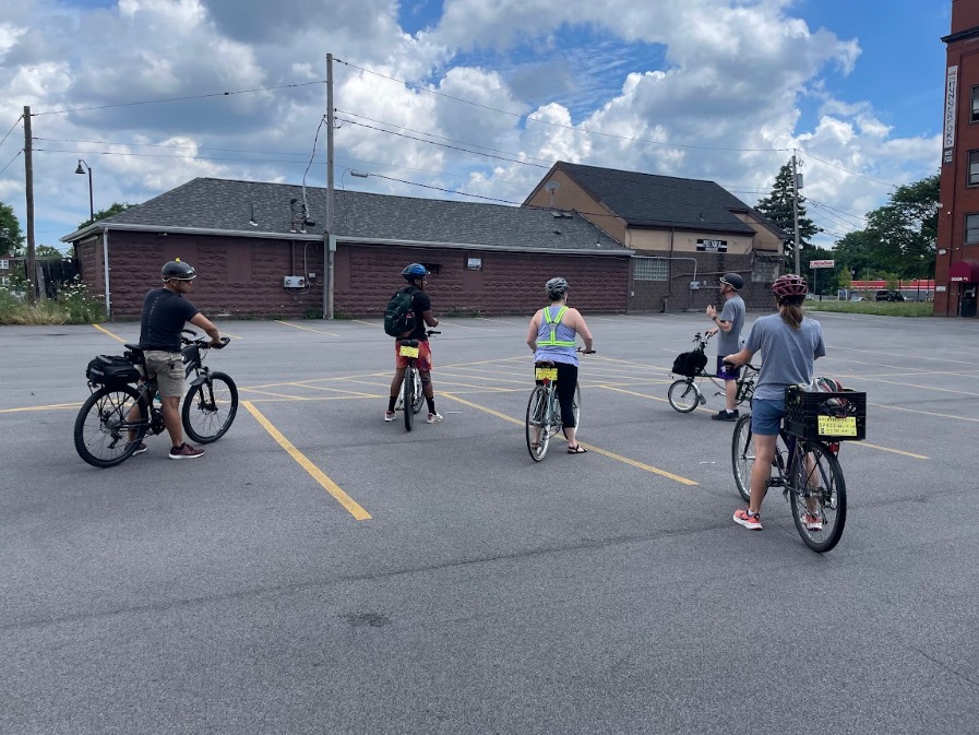
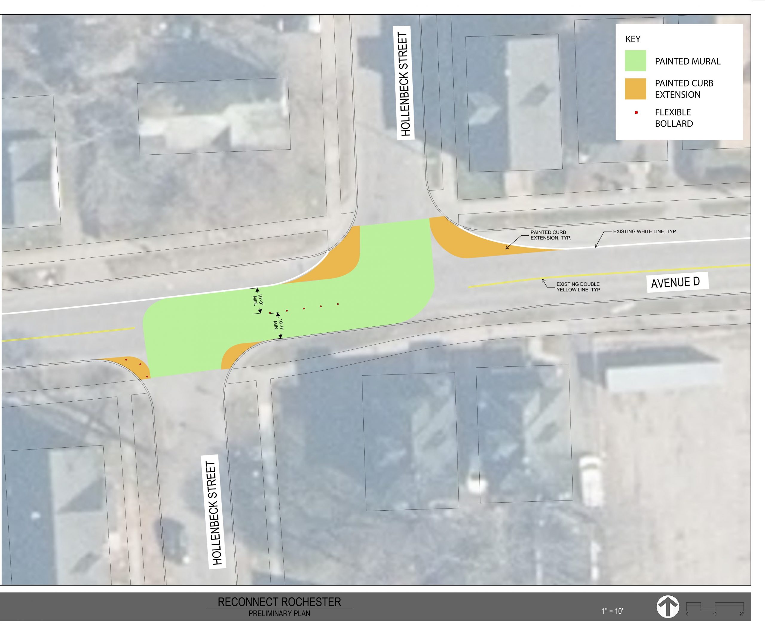
By Jesse Peers, Cycling Manager
Reconnect Rochester felt it was time to answer a few frequently asked bike questions and put some disparate information in one place. Some of the rules for bicycle riders in New York are well-reasoned and straightforward; others are nonsensical. The good news: Laws can be and are updated regularly. Be the squeaky wheel that gets the grease. 😉
First off, let’s get this misconception out of the way: There is no statewide ban on sidewalk riding.
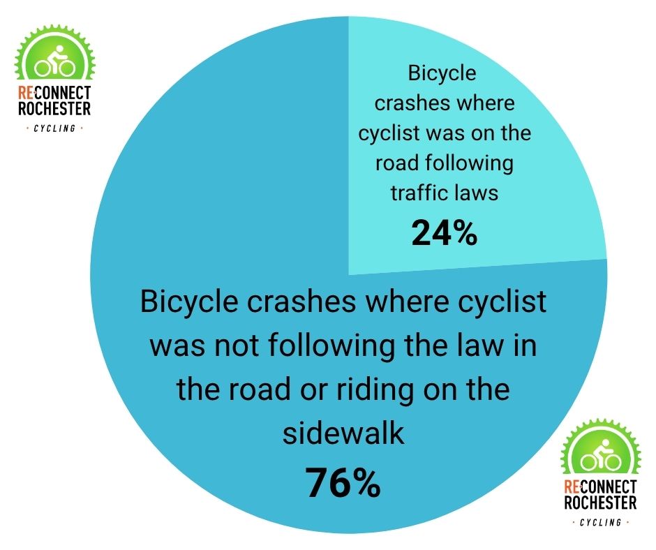
From our analysis of crash reports, it’s evident that some law enforcement don’t know this.
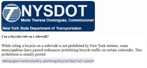
As this State DOT FAQ lays out, municipalities can choose to ban sidewalk riding. New York City and Buffalo prohibit it. As do the villages of Brockport and Scottsville locally. As we previously explored, Rochester’s ban on sidewalk riding was taken away in 1958.
Riders in Monroe County, therefore, often have a choice: They can ride in the road following motorists’ rules, or if they don’t feel safe, they have the option of riding on the sidewalk where the law treats them more or less*** as pedestrians. Sidewalk-riding cyclists have to yield to pedestrians. In other words, pedestrians don’t have to get out of cyclists’ way on the sidewalk.
As we’ve stated before, in general: sidewalk-riding isn’t as safe as many assume and riding in the road, on the right side, isn’t as dangerous as many assume. But Reconnect Rochester has nuance: We’ll admit there are circumstances where the sidewalk is the safest place to ride.
Sidewalk riding downtown is discouraged. For many years, it was explicitly prohibited. But in 2019, the City Council updated the code. There’s wiggle room now: A cyclist can ride on downtown sidewalks if they feel imperiled (“if reasonably necessary to avoid unsafe conditions” in the road).

It should be noted that in the City of Rochester, kids under the age of 13 can’t ride in the road unless accompanied by an adult. Experts tell us that peripheral vision and the ability to judge how fast an approaching vehicle will be in your space just isn’t developed in youngsters. So young riders must stick to the sidewalk when riding without an adult. Here are other tips for youngsters.
A sticky point that’s become a contentious issue with law enforcement: When cyclists ride in the roadway, we acknowledge they’re required to ride on the right side with the flow of traffic. Because New York State does not define sidewalks as part of the roadway, cyclists can technically ride in each direction on the sidewalk, just as pedestrians can walk each way on the sidewalk, when sidewalk-riding isn’t prohibited. (Though it’s far safer, bicyclists don’t have to ride on the sidewalk on the right side of the road in their direction of travel).
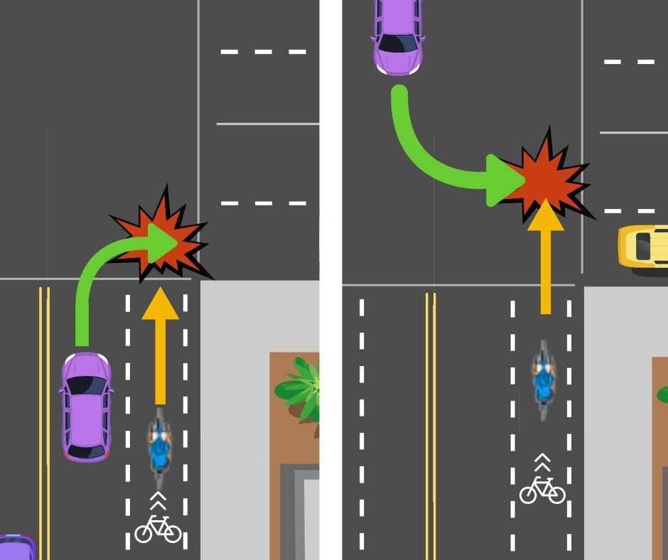
We’ve seen Police Reports where the Officer reprimands a cyclist for riding on the sidewalk on the left side of the road, even if there is no sidewalk on the right side. Cyclists do have the right, though riding on the left sidewalk opens them up to this common motorist mistake.
Just because riding on the sidewalk is allowed, doesn’t mean it’s beneficial [in every circumstance]. We only recommend it for brief, finite maneuvers when the cyclist can use it to their advantage.
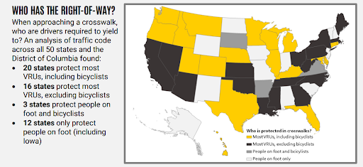
Motorists in New York are legally required to yield to pedestrians in crosswalks. The “common law” interpretation of this is for motorists to yield to cyclists in crosswalks too (and we occasionally see motorists ticketed for failing to do so), but it’s not explicitly stated. Though cyclists are not legally required to dismount and walk their bike across the crosswalk, doing so protects them more in a legal sense. As Cara Hamann states in this important article, “There is a simple and straightforward fix to the legal loophole in crosswalk laws: change the word ‘pedestrian’ to ‘persons.’” We find it interesting that in the NYS Driver’s Manual, motorists are instructed to yield to pedestrians, in-line skaters and scooters in crosswalks. Bicycles are missing from that directive.
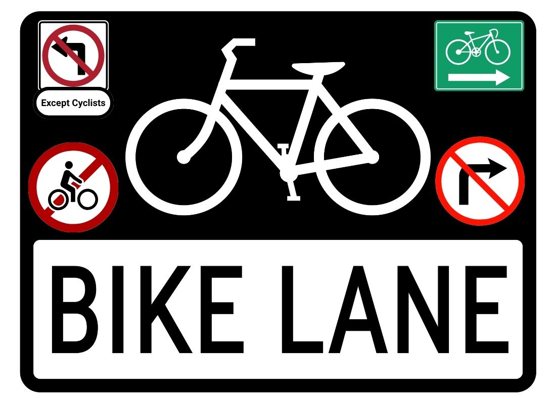
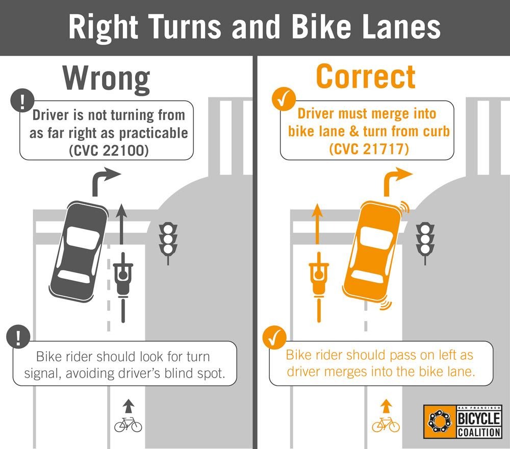
When there’s a dedicated bike facility and it’s usable and unobstructed, it’s state law for the cyclist to use it (except to come out to prepare for a turn). A bicyclist could be ticketed, for example, for riding on Union Street itself rather than the raised cycle track running alongside Union Street.
When it “legalized” e-bikes in 2020, New York State blanketly banned e-bikes (and e-scooters) from sidewalks. But municipalities have the option of allowing them on sidewalks. Rochester was one of the first to do so.
A quirk of New York State’s e-bike law is that e-bikes (and e-scooters) are prohibited on roads with speed limits greater than 30 mph. This more or less only makes e-bikes legal in cities, villages and quieter residential streets. Most riders in the suburbs are unknowingly riding illegally on their primary roadways. There’s a bill in the legislature that would fix this. Prod your Albany reps. 😉
It’s worth noting: One of the reasons that Upstate New York’s Sidepath networks disappeared in the early 1900s was that different rules throughout the state just didn’t make sense. History is repeating itself in that sense with e-bike rules.
There’s a whole book devoted to New York’s weird e-bike laws. Since it’s becoming an issue, we’ll point out that you have to be 16+up to ride an e-bike. Crashes involving riders younger than 16 are spiking up, which could have wider repercussions…
This comes as a surprise to many: Monroe County doesn’t allow bikes on trails or paths in County Parks with the exception of Tryon, Irondequoit Bay West, Genesee Valley Park, the Lehigh Valley Trail, and that short section of Highland Park South (Biekrich Park) where the Highland Crossing Trail is. However, folks can bike on any paved road in the park system that is open to cars.
The following Towns also don’t allow biking on footpaths and trails in their parks:
- Brighton
- Brockport
- Ogden
- Penfield
- Riga
- Webster
Our understanding is that trails throughout New York that are open to bicycles are not automatically open to e-bikes. The entity that has jurisdiction over the trail can choose to allow them. The only local trails that we know allow e-bikes are the Erie Canal and Genesee Riverway Trails. City Trails such as the El Camino Trail are technically not yet open to e-bikes. If you come across any information that contradicts this or any more local trails that allow it, let us know.
New York State law permits cyclists to ride two abreast if sufficient space is available. But the following municipalities require riders to be single file at all times:
- Brighton
- Ogden
- Penfield
- Webster
- Fairport
Finally, as many riders know, bicycle riding is prohibited on the Erie Canal towpath between the Main Street bridge and the State Street Bridge in the Village of Pittsford, and dismounting of bicycles on the towpath in that area is required.


")

")


")
")

")


